STS036-81-16
| NASA Photo ID | STS036-81-16 |
| Focal Length | 100mm |
| Date taken | 1990.02.28 |
| Time taken | 17:13:25 GMT |


Cloud masks available for this image:
Spacecraft nadir point: 41.9° N, 87.0° W
Photo center point: 41.5° N, 87.0° W
Photo center point by machine learning:
Photo center point: 41.5° N, 87.0° W
Photo center point by machine learning:
Nadir to Photo Center: South
Spacecraft Altitude: 133 nautical miles (246km)
Country or Geographic Name: | USA-INDIANA |
Features: | CHICAGO, LAKE MICHIGAN |
| Features Found Using Machine Learning: | |
Cloud Cover Percentage: | 10 (1-10)% |
Sun Elevation Angle: | 39° |
Sun Azimuth: | 165° |
Camera: | Hasselblad |
Focal Length: | 100mm |
Camera Tilt: | 10 degrees |
Format: | 5036: Kodak, natural color positive, Ektachrome 5036,200 Professional, ASA 200, stand |
Film Exposure: | Normal |
| Additional Information | |
| Width | Height | Annotated | Cropped | Purpose | Links |
|---|---|---|---|---|---|
| 5700 pixels | 5900 pixels | No | No | Download Image | |
| 500 pixels | 518 pixels | No | No | Download Image | |
| 640 pixels | 480 pixels | No | No | Download Image |
Download Packaged File
Download a Google Earth KML for this Image
View photo footprint information
Download a GeoTIFF for this photo
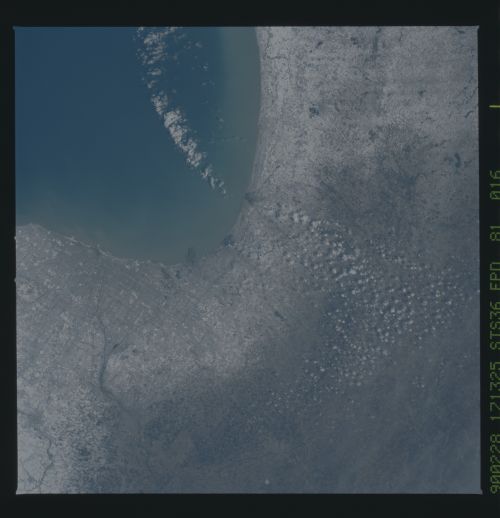
Image Caption: In this late winter scene of Chicago, Illinois, USA (41.5N, 87.0W) the light dusting of snow has actually enhanced the determination of the cities street pattern, parks and other cultural features. Sited at the south end of Lake Michigan, Chicago has long served as an industrial, transportation and communications center for the midwest. The obvious snowline on the ground enables meteorologists to trace the regional groundtracks of winter storms.
