STS036-74-75
| NASA Photo ID | STS036-74-75 |
| Focal Length | 100mm |
| Date taken | 1990.03.04 |
| Time taken | 07:35:08 GMT |
Resolutions offered for this image:
5237 x 5237 pixels 640 x 640 pixels 5700 x 5900 pixels 500 x 518 pixels 640 x 480 pixels
5237 x 5237 pixels 640 x 640 pixels 5700 x 5900 pixels 500 x 518 pixels 640 x 480 pixels
Cloud masks available for this image:
Spacecraft nadir point: 29.8° N, 50.0° E
Photo center point: 30.0° N, 49.0° E
Photo center point by machine learning:
Photo center point: 30.0° N, 49.0° E
Photo center point by machine learning:
Nadir to Photo Center: West
Spacecraft Altitude: 115 nautical miles (213km)
Country or Geographic Name: | IRAN |
Features: | PERSIAN GULF |
| Features Found Using Machine Learning: | |
Cloud Cover Percentage: | 0 (no clouds present) |
Sun Elevation Angle: | 49° |
Sun Azimuth: | 150° |
Camera: | Hasselblad |
Focal Length: | 100mm |
Camera Tilt: | 28 degrees |
Format: | 5017: Kodak, natural color positive, Ektachrome, X Professional, ASA 64, standard base |
Film Exposure: | Normal |
| Additional Information | |
| Width | Height | Annotated | Cropped | Purpose | Links |
|---|---|---|---|---|---|
| 5237 pixels | 5237 pixels | No | No | Earth From Space collection | Download Image |
| 640 pixels | 640 pixels | No | No | Earth From Space collection | Download Image |
| 5700 pixels | 5900 pixels | No | No | Download Image | |
| 500 pixels | 518 pixels | No | No | Download Image | |
| 640 pixels | 480 pixels | No | No | Download Image |
Download Packaged File
Download a Google Earth KML for this Image
View photo footprint information
Download a GeoTIFF for this photo
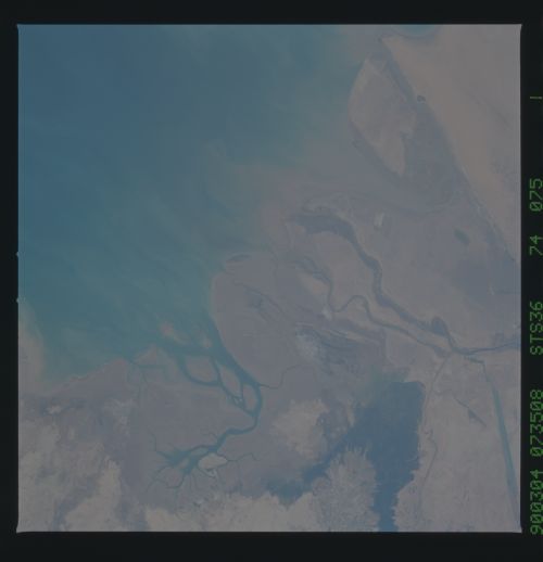
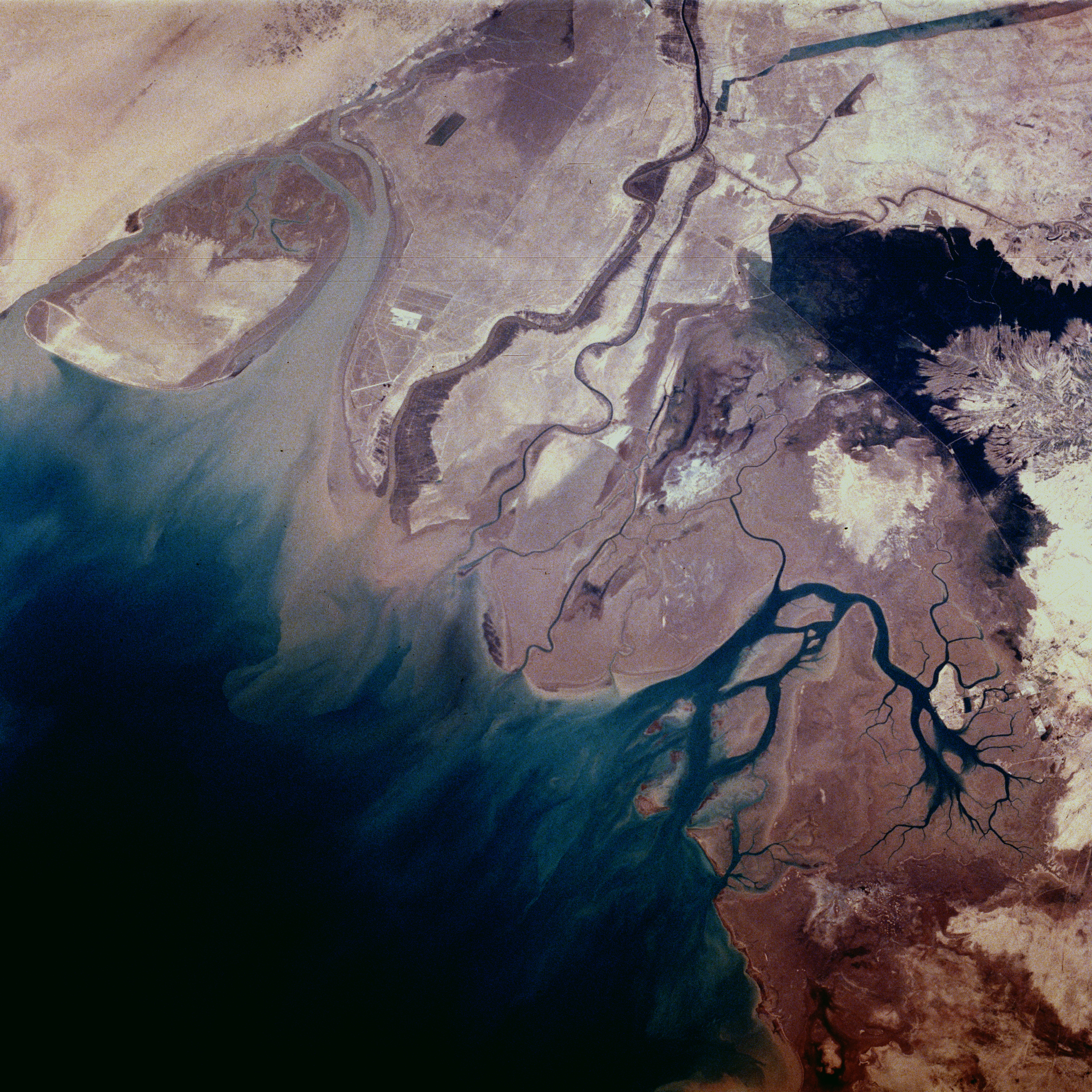
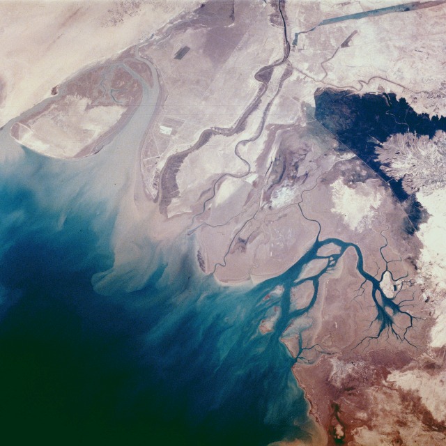
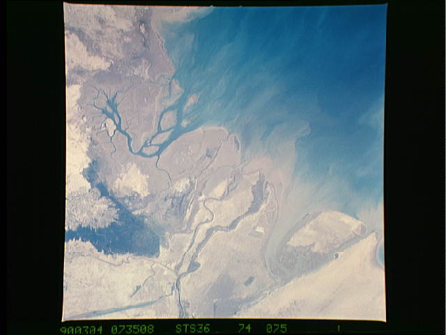
Image Caption: STS036-074-075 Wetlands of the Middle East--Iran, Iraq, and Kuwait March 1990
The northern end of the Persian Gulf provides a sharp contrast to the arid-looking wetlands of northeast Kuwait (Bubiyan Island), the narrow corridor of Iraq, and the west-southwest marshes of Iran. The delta of the Tigris and Euphrates Rivers has suffered substantial environmental changes because of drainage, pollution, and urban and industrial development. Water normally supplied to the region has been diverted for irrigation and domestic and industrial consumption; wetlands have been drained for agriculture and industrial purposes; and the construction of dams has decreased the amount of fresh water from the Tigris and Euphrates Rivers, resulting in small quantities of silt being deposited in the delta of these once mighty rivers. The boundaries for Kuwait, Iraq, and Iran are not easily distinguishable in this photograph. The large dark area in Iran appears to be a freshwater marsh. Because natural materials are used for construction, the few towns and villages within the delta area tend to blend with the natural environment.
The northern end of the Persian Gulf provides a sharp contrast to the arid-looking wetlands of northeast Kuwait (Bubiyan Island), the narrow corridor of Iraq, and the west-southwest marshes of Iran. The delta of the Tigris and Euphrates Rivers has suffered substantial environmental changes because of drainage, pollution, and urban and industrial development. Water normally supplied to the region has been diverted for irrigation and domestic and industrial consumption; wetlands have been drained for agriculture and industrial purposes; and the construction of dams has decreased the amount of fresh water from the Tigris and Euphrates Rivers, resulting in small quantities of silt being deposited in the delta of these once mighty rivers. The boundaries for Kuwait, Iraq, and Iran are not easily distinguishable in this photograph. The large dark area in Iran appears to be a freshwater marsh. Because natural materials are used for construction, the few towns and villages within the delta area tend to blend with the natural environment.
