STS036-151-245
| NASA Photo ID | STS036-151-245 |
| Focal Length | 250mm |
| Date taken | 1990.__.__ |
| Time taken | GMT |
Resolutions offered for this image:
640 x 480 pixels
640 x 480 pixels
Cloud masks available for this image:
Spacecraft nadir point:
Photo center point: 45.5° N, 83.5° W
Photo center point by machine learning:
Photo center point: 45.5° N, 83.5° W
Photo center point by machine learning:
Nadir to Photo Center:
Spacecraft Altitude: nautical miles (0km)
Country or Geographic Name: | USA-MICHIGAN |
Features: | NO. SIDE, L. MI/L. HUR, SNOW |
| Features Found Using Machine Learning: | |
Cloud Cover Percentage: | 20 (11-25)% |
Sun Elevation Angle: | ° |
Sun Azimuth: | ° |
Camera: | Linhof |
Focal Length: | 250mm |
Camera Tilt: | High Oblique |
Format: | QX868: Kodak, natural color positive, Ektachrome QX868(5017 emulsion), ASA 64, thin base |
Film Exposure: | Normal |
| Additional Information | |
| Width | Height | Annotated | Cropped | Purpose | Links |
|---|---|---|---|---|---|
| 640 pixels | 480 pixels | No | No | ISD 1 | Download Image |
Download Packaged File
Download a Google Earth KML for this Image
View photo footprint information
Download a GeoTIFF for this photo
Image Caption:
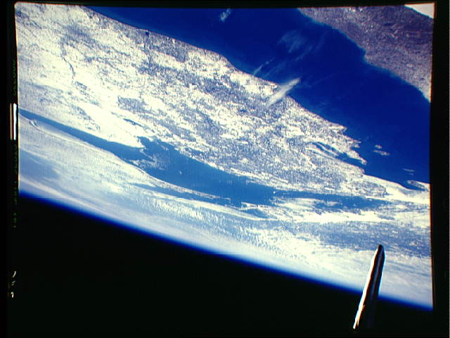
S36-151-245: State of Michigan, Lakes Michigan and Huron This
oblique view looking northeast shows Lake Michigan at the bottom
left, the northern two-thirds of the state of Michigan at the
lower center of the view and Lake Huron near the center of the
photograph. RLake effectS snows from Lake Michigan will deposit
heavy snowfall amounts over most of the state of Michigan. Less
snowfall occurs on the Wisconsin or lee side of the lake as seen
in the lower left of the scene. Lake effect snows occur as cold-
er air crosses over the warmer surfaces of the lake depositing
snows on the downwind side of the lake. Ice floes can be detect-
ed in Saginaw Bay near the center right of the view.
Almost the entire state of Michigan and most of lakes Michigan and Huron (45.5N, 83.5W) can be seen in this single midwinter view of the Great Lakes region. Even under midwinter snow and ice conditions, the distinctive silhouette of the state of Michigan is still easy to recognize as well as Lakes Michigan and Huron. The Canadian province of Ontario is at the top of the scene on the opposite shore from Michigan.
