STS034-78-31

| NASA Photo ID | STS034-78-31 |
| Focal Length | 250mm |
| Date taken | 1989.10.20 |
| Time taken | 03:44:23 GMT |
Resolutions offered for this image:
5265 x 5265 pixels 639 x 639 pixels 5700 x 5900 pixels 500 x 518 pixels 640 x 480 pixels
5265 x 5265 pixels 639 x 639 pixels 5700 x 5900 pixels 500 x 518 pixels 640 x 480 pixels


Cloud masks available for this image:
Spacecraft nadir point: 30.2° N, 112.2° E
Photo center point: 29.0° N, 112.0° E
Photo center point by machine learning:
Photo center point: 29.0° N, 112.0° E
Photo center point by machine learning:
Nadir to Photo Center: South
Spacecraft Altitude: 178 nautical miles (330km)
Country or Geographic Name: | CHINA |
Features: | DONGTING L, XIANG R, AGR |
| Features Found Using Machine Learning: | |
Cloud Cover Percentage: | 0 (no clouds present) |
Sun Elevation Angle: | 48° |
Sun Azimuth: | 168° |
Camera: | Hasselblad |
Focal Length: | 250mm |
Camera Tilt: | 22 degrees |
Format: | 5017: Kodak, natural color positive, Ektachrome, X Professional, ASA 64, standard base |
Film Exposure: | Normal |
| Additional Information | |
| Width | Height | Annotated | Cropped | Purpose | Links |
|---|---|---|---|---|---|
| 5265 pixels | 5265 pixels | No | No | Earth From Space collection | Download Image |
| 639 pixels | 639 pixels | No | No | Earth From Space collection | Download Image |
| 5700 pixels | 5900 pixels | No | No | Download Image | |
| 500 pixels | 518 pixels | No | No | Download Image | |
| 640 pixels | 480 pixels | No | No | Download Image |
Download Packaged File
Download a Google Earth KML for this Image
View photo footprint information
Download a GeoTIFF for this photo
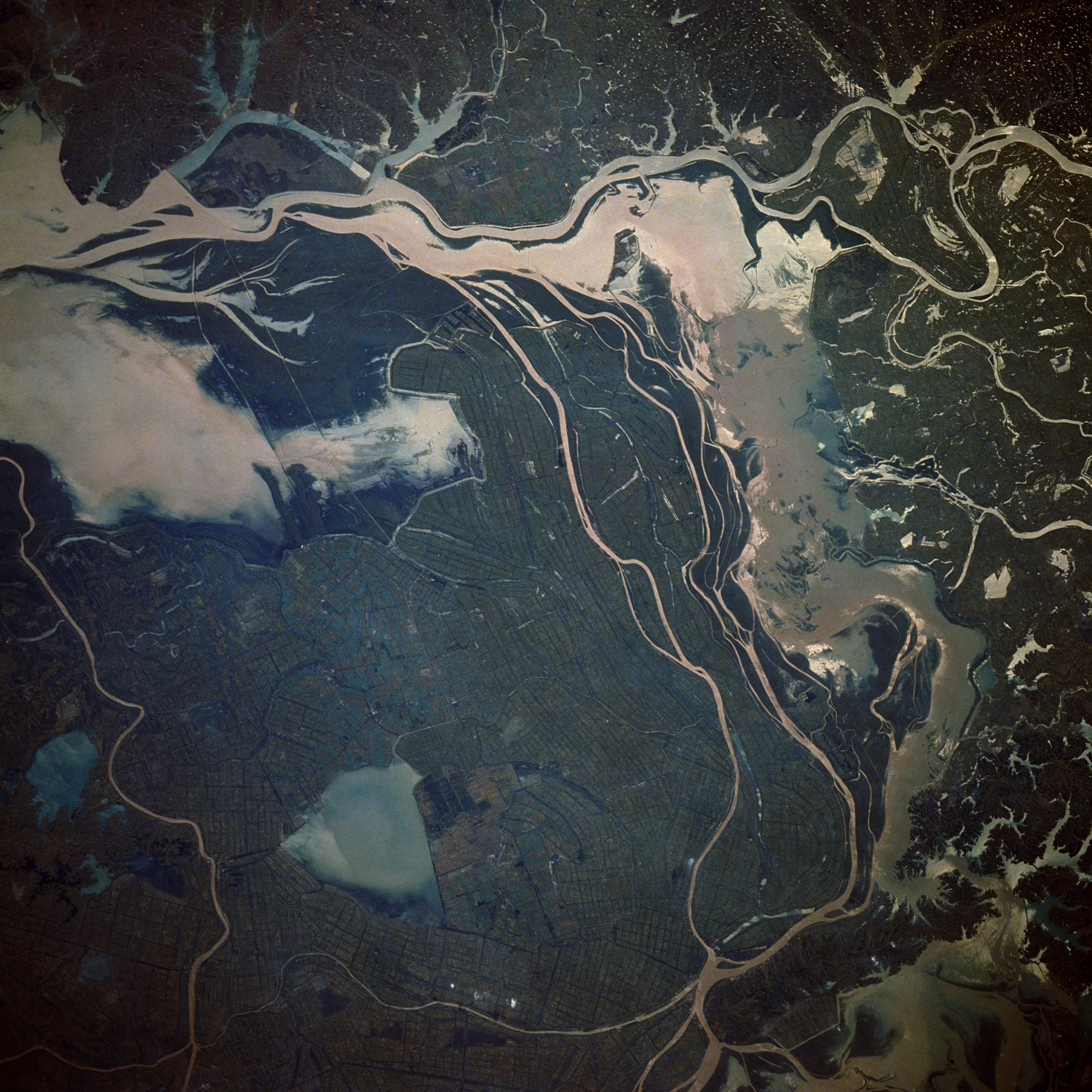
Image Caption: STS034-078-031 Chang Jiang (River), China October 1989
Located approximately 50 miles (80 kilometers) north of Changsha in northern Hunan Province, this complex, hydrologically controlled lake region looks almost surreal. Identifying specific rivers that enter this region is difficult because of many crisscrossing rivers, lakes, irrigation canals, and ditches. Two major rivers, the east-flowing Yuan River and the north-flowing Xiang River, merge near the eastern edge of the photograph and flow northeastward into the mighty Chang (Yangtze) River (not shown in this photograph). Triangular Datong Lake (northern area of the photograph) is surrounded by extensive, cultivated field patterns, most of which are presumed to be irrigated rice paddies. The two larger lakes are known collectively as Lake Dongting.
Located approximately 50 miles (80 kilometers) north of Changsha in northern Hunan Province, this complex, hydrologically controlled lake region looks almost surreal. Identifying specific rivers that enter this region is difficult because of many crisscrossing rivers, lakes, irrigation canals, and ditches. Two major rivers, the east-flowing Yuan River and the north-flowing Xiang River, merge near the eastern edge of the photograph and flow northeastward into the mighty Chang (Yangtze) River (not shown in this photograph). Triangular Datong Lake (northern area of the photograph) is surrounded by extensive, cultivated field patterns, most of which are presumed to be irrigated rice paddies. The two larger lakes are known collectively as Lake Dongting.
