STS033-82-103
| NASA Photo ID | STS033-82-103 |
| Focal Length | 40mm |
| Date taken | 1989.11.25 |
| Time taken | 03:51:57 GMT |

Cloud masks available for this image:
Spacecraft nadir point: 28.2° S, 43.3° E
Photo center point: 22.0° S, 45.5° E
Photo center point by machine learning:
Photo center point: 22.0° S, 45.5° E
Photo center point by machine learning:
Nadir to Photo Center: North
Spacecraft Altitude: 289 nautical miles (535km)
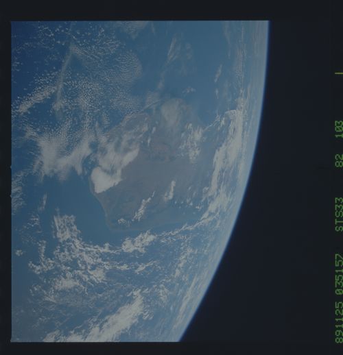
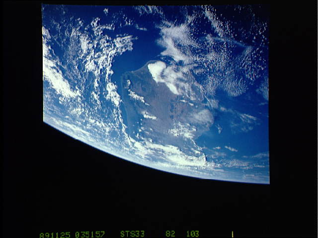
Country or Geographic Name: | MADAGASCAR |
Features: | SOUTHERN TIP |
| Features Found Using Machine Learning: | |
Cloud Cover Percentage: | 80 (76-100)% |
Sun Elevation Angle: | 22° |
Sun Azimuth: | 103° |
Camera: | Hasselblad |
Focal Length: | 40mm |
Camera Tilt: | High Oblique |
Format: | 5017: Kodak, natural color positive, Ektachrome, X Professional, ASA 64, standard base |
Film Exposure: | Normal |
| Additional Information | |
| Width | Height | Annotated | Cropped | Purpose | Links |
|---|---|---|---|---|---|
| 5700 pixels | 5900 pixels | No | No | Download Image | |
| 500 pixels | 518 pixels | No | No | Download Image | |
| 640 pixels | 480 pixels | No | No | Download Image |
Download Packaged File
Download a Google Earth KML for this Image
View photo footprint information
Download a GeoTIFF for this photo
Image Caption: This high oblique view shows the majority of the island of Madagascar (22.0S, 45.5E). This Texas sized island is now largely deforested and is suffering from severe soil erosion as well as a declining biological species diversity and productivity. At the turn of the century, the island was almost totally forested but now, forests cover only about 10 percent of the surface. Evidence of soil erosion can be seen in the offshore sediment plumes.
