STS031-72-69
| NASA Photo ID | STS031-72-69 |
| Focal Length | 100mm |
| Date taken | 1990.04.25 |
| Time taken | 11:42:06 GMT |

Cloud masks available for this image:
Spacecraft nadir point: 11.5° S, 38.0° E
Photo center point: 8.0° S, 30.0° E
Photo center point by machine learning:
Photo center point: 8.0° S, 30.0° E
Photo center point by machine learning:
Nadir to Photo Center: West
Spacecraft Altitude: 331 nautical miles (613km)
Country or Geographic Name: | DEM. REP. OF CONGO |
Features: | L. TANGANYIKA/CHISHI/RUKW |
| Features Found Using Machine Learning: | |
Cloud Cover Percentage: | 85 (76-100)% |
Sun Elevation Angle: | 48° |
Sun Azimuth: | 305° |
Camera: | Hasselblad |
Focal Length: | 100mm |
Camera Tilt: | High Oblique |
Format: | 5017: Kodak, natural color positive, Ektachrome, X Professional, ASA 64, standard base |
Film Exposure: | Normal |
| Additional Information | |
| Width | Height | Annotated | Cropped | Purpose | Links |
|---|---|---|---|---|---|
| 5700 pixels | 5900 pixels | No | No | Download Image | |
| 500 pixels | 518 pixels | No | No | Download Image | |
| 640 pixels | 480 pixels | No | No | Download Image |
Download Packaged File
Download a Google Earth KML for this Image
View photo footprint information
Download a GeoTIFF for this photo
Image Caption:
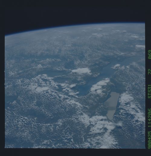
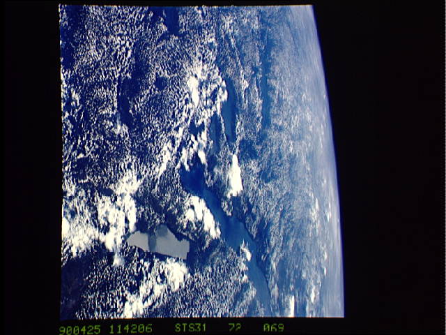
East African Rift (S31-72-069). This photo provides an excellent
example of differential heating of land and water. This image
was taken on 25 Apr 90 at 11:42Z while the Shuttle was over the
southeastern portion of Africa. The view is to the Northwest.
Lake Tanganyika and several smaller lakes are nearly cloud free.
Because the local time was early afternoon, the land areas have
warmed sufficiently to cause the formation of widespread small
cumulus clouds over land. In contrast, the cooler water areas do
not warm the lower layers of the atmosphere which result in rela-
tively stable conditions over water and no development of cumulus
clouds. Over the interior of the continent, several thunderstorm
anvils are visible poking through the hazy lower layers of the
atmosphere.
