STS028-90-13
| NASA Photo ID | STS028-90-13 |
| Focal Length | 250mm |
| Date taken | 1989.08.12 |
| Time taken | 21:02:08 GMT |
Resolutions offered for this image:
5302 x 5302 pixels 639 x 639 pixels 5700 x 5900 pixels 500 x 518 pixels 640 x 480 pixels
5302 x 5302 pixels 639 x 639 pixels 5700 x 5900 pixels 500 x 518 pixels 640 x 480 pixels


Cloud masks available for this image:
Spacecraft nadir point: 57.1° N, 158.4° W
Photo center point: 58.5° N, 155.0° W
Photo center point by machine learning:
Photo center point: 58.5° N, 155.0° W
Photo center point by machine learning:
Nadir to Photo Center: East
Spacecraft Altitude: 161 nautical miles (298km)
Country or Geographic Name: | USA-ALASKA |
Features: | ALEUTIAN RANGE |
| Features Found Using Machine Learning: | |
Cloud Cover Percentage: | 20 (11-25)% |
Sun Elevation Angle: | 44° |
Sun Azimuth: | 147° |
Camera: | Hasselblad |
Focal Length: | 250mm |
Camera Tilt: | 54 degrees |
Format: | 5017: Kodak, natural color positive, Ektachrome, X Professional, ASA 64, standard base |
Film Exposure: | Normal |
| Additional Information | |
| Width | Height | Annotated | Cropped | Purpose | Links |
|---|---|---|---|---|---|
| 5302 pixels | 5302 pixels | No | No | Earth From Space collection | Download Image |
| 639 pixels | 639 pixels | No | No | Earth From Space collection | Download Image |
| 5700 pixels | 5900 pixels | No | No | Download Image | |
| 500 pixels | 518 pixels | No | No | Download Image | |
| 640 pixels | 480 pixels | No | No | Download Image |
Download Packaged File
Download a Google Earth KML for this Image
View photo footprint information
Download a GeoTIFF for this photo
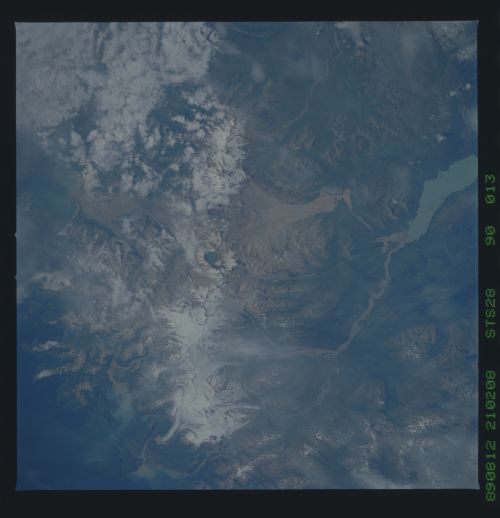
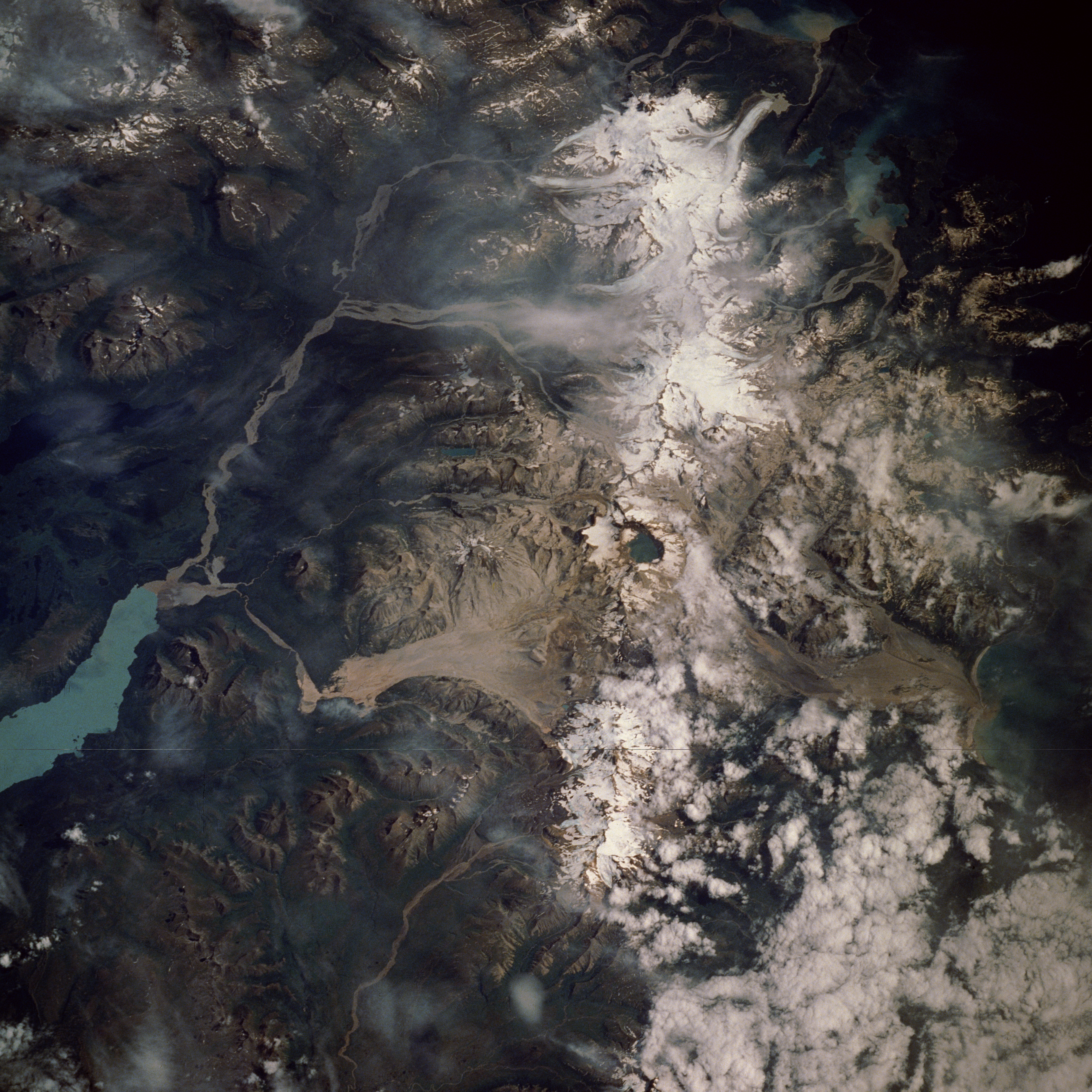
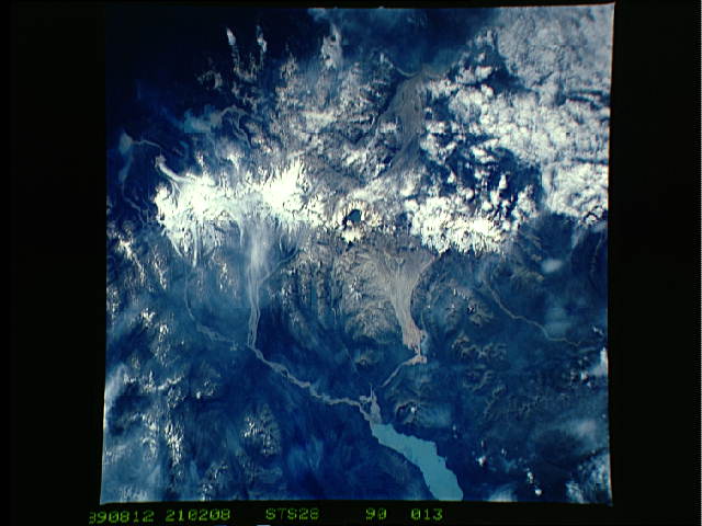
Image Caption: STS028-90-13 Katmai National Monument, Alaska, U.S.A. August 1989
The second-largest unit of the U.S. National Park System (Yellowstone is the largest), Katmai National Monument and the Valley of Ten Thousand Smokes can be seen in this east-northeast-looking, low-oblique photograph. Located near the northern end of the Alaskan Peninsula, Katmai sits in a presently dormant volcanic region. In 1912, this region was the site of one of the greatest eruptions in recent history. As lava beneath Mount Katmai drained to the west, Novarupta Volcano erupted and then collapsed, forming a huge crater 8 miles (13 kilometers) in circumference and 3700 feet (1129 meters) deep (near the center of the photograph), which formed a lake. The explosion of Novarupta caused 40 square miles (100 square kilometers) of terrain around the volcano to be covered in ash and pumice as deep as 300 feet (90 meters). The Valley of Ten Thousand Smokes to the north-northwest of Novarupta Volcano [72 square miles (187 square kilometers)] had countless holes and cracks (fumeroles) on the surface, through which scalding hot gases (steam) passed to the surface--hence the valley's name. Today, all but a few of these volcanoes are extinct. Scars or deposits of ash and pumice (grayish-color) from the eruption can still be seen north and south of the water-filled crater. Plants have begun to colonize some portions of the valley. The light blue waters of Naknek Lake can be seen northwest of the Novarupta Crater.
The second-largest unit of the U.S. National Park System (Yellowstone is the largest), Katmai National Monument and the Valley of Ten Thousand Smokes can be seen in this east-northeast-looking, low-oblique photograph. Located near the northern end of the Alaskan Peninsula, Katmai sits in a presently dormant volcanic region. In 1912, this region was the site of one of the greatest eruptions in recent history. As lava beneath Mount Katmai drained to the west, Novarupta Volcano erupted and then collapsed, forming a huge crater 8 miles (13 kilometers) in circumference and 3700 feet (1129 meters) deep (near the center of the photograph), which formed a lake. The explosion of Novarupta caused 40 square miles (100 square kilometers) of terrain around the volcano to be covered in ash and pumice as deep as 300 feet (90 meters). The Valley of Ten Thousand Smokes to the north-northwest of Novarupta Volcano [72 square miles (187 square kilometers)] had countless holes and cracks (fumeroles) on the surface, through which scalding hot gases (steam) passed to the surface--hence the valley's name. Today, all but a few of these volcanoes are extinct. Scars or deposits of ash and pumice (grayish-color) from the eruption can still be seen north and south of the water-filled crater. Plants have begun to colonize some portions of the valley. The light blue waters of Naknek Lake can be seen northwest of the Novarupta Crater.
