STS028-87-61
| NASA Photo ID | STS028-87-61 |
| Focal Length | 100mm |
| Date taken | 1989.08.11 |
| Time taken | 10:28:24 GMT |
Resolutions offered for this image:
4096 x 4096 pixels 640 x 640 pixels 5700 x 5900 pixels 500 x 518 pixels 640 x 480 pixels
4096 x 4096 pixels 640 x 640 pixels 5700 x 5900 pixels 500 x 518 pixels 640 x 480 pixels


Cloud masks available for this image:
Spacecraft nadir point: 44.6° N, 56.5° E
Photo center point: 45.5° N, 53.0° E
Photo center point by machine learning:
Photo center point: 45.5° N, 53.0° E
Photo center point by machine learning:
Nadir to Photo Center: West
Spacecraft Altitude: 163 nautical miles (302km)
Country or Geographic Name: | KAZAKHSTAN |
Features: | CASPIAN SEA |
| Features Found Using Machine Learning: | |
Cloud Cover Percentage: | 0 (no clouds present) |
Sun Elevation Angle: | 50° |
Sun Azimuth: | 233° |
Camera: | Hasselblad |
Focal Length: | 100mm |
Camera Tilt: | 53 degrees |
Format: | 5017: Kodak, natural color positive, Ektachrome, X Professional, ASA 64, standard base |
Film Exposure: | Normal |
| Additional Information | |
| Width | Height | Annotated | Cropped | Purpose | Links |
|---|---|---|---|---|---|
| 4096 pixels | 4096 pixels | No | No | Earth From Space collection | Download Image |
| 640 pixels | 640 pixels | No | No | Earth From Space collection | Download Image |
| 5700 pixels | 5900 pixels | No | No | Download Image | |
| 500 pixels | 518 pixels | No | No | Download Image | |
| 640 pixels | 480 pixels | No | No | Download Image |
Download Packaged File
Download a Google Earth KML for this Image
View photo footprint information
Download a GeoTIFF for this photo
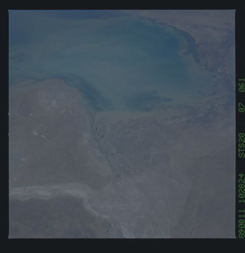
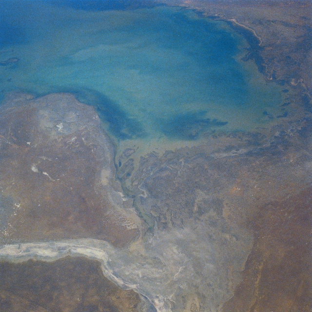
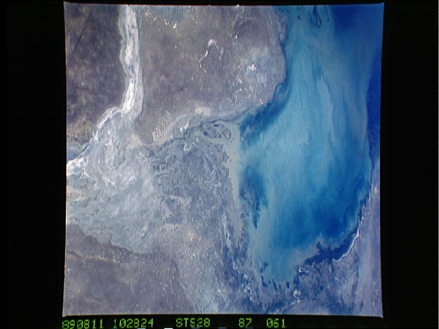
Image Caption: STS028-087-061 Caspian Sea, Mertvyy Kultuk Salt Flat, Kazakhstan August 1989
This west-looking view shows the northeast section of the Caspian Sea. The Caspian Sea is the world's largest inland expanse of water. The northern part of the sea visible in this view, reaches a depth of only 17 feet (5 meters). The Mertvyy Kultuk Salt Flat (bottom center) and the Kaydak Salt Flat (bottom left) are a part of the Caspian Depression and were once covered with water. The mouth of the Ural River is visible along the top of the image. The outer edges of the Volga River Delta are visible near the top center of the image. The area shown in this view is semi-arid, and is also noted for its many oil and gas fields.
This west-looking view shows the northeast section of the Caspian Sea. The Caspian Sea is the world's largest inland expanse of water. The northern part of the sea visible in this view, reaches a depth of only 17 feet (5 meters). The Mertvyy Kultuk Salt Flat (bottom center) and the Kaydak Salt Flat (bottom left) are a part of the Caspian Depression and were once covered with water. The mouth of the Ural River is visible along the top of the image. The outer edges of the Volga River Delta are visible near the top center of the image. The area shown in this view is semi-arid, and is also noted for its many oil and gas fields.
