STS028-78-3

| NASA Photo ID | STS028-78-3 |
| Focal Length | 250mm |
| Date taken | 1989.08.09 |
| Time taken | 12:53:36 GMT |
Resolutions offered for this image:
5320 x 5266 pixels 640 x 633 pixels 5700 x 5900 pixels 500 x 518 pixels 640 x 480 pixels
5320 x 5266 pixels 640 x 633 pixels 5700 x 5900 pixels 500 x 518 pixels 640 x 480 pixels

Cloud masks available for this image:
Spacecraft nadir point: 39.0° N, 78.2° W
Photo center point: 39.0° N, 77.0° W
Photo center point by machine learning:
Photo center point: 39.0° N, 77.0° W
Photo center point by machine learning:
Nadir to Photo Center: East
Spacecraft Altitude: 161 nautical miles (298km)
Country or Geographic Name: | USA-DC |
Features: | WASHINGTON D. C. |
| Features Found Using Machine Learning: | |
Cloud Cover Percentage: | 0 (no clouds present) |
Sun Elevation Angle: | 28° |
Sun Azimuth: | 92° |
Camera: | Hasselblad |
Focal Length: | 250mm |
Camera Tilt: | 24 degrees |
Format: | 5017: Kodak, natural color positive, Ektachrome, X Professional, ASA 64, standard base |
Film Exposure: | Normal |
| Additional Information | |
| Width | Height | Annotated | Cropped | Purpose | Links |
|---|---|---|---|---|---|
| 5320 pixels | 5266 pixels | No | No | Earth From Space collection | Download Image |
| 640 pixels | 633 pixels | No | No | Earth From Space collection | Download Image |
| 5700 pixels | 5900 pixels | No | No | Download Image | |
| 500 pixels | 518 pixels | No | No | Download Image | |
| 640 pixels | 480 pixels | No | No | Download Image |
Download Packaged File
Download a Google Earth KML for this Image
View photo footprint information
Download a GeoTIFF for this photo
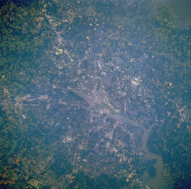
Image Caption: STS028-078-003 Washington, District of Columbia, U.S.A. August 1989
The legislative, administrative, and judicial center of the United States, Washington, DC, can be seen in this east-northeast-looking, low-oblique photograph. Situated on the banks of the Potomac and Anacostia Rivers, the District of Columbia covers 69 square miles (179 square kilometers). The population of metropolitan Washington, which includes suburbs in both Maryland and Virginia, is the eighth largest in the United States (3.9 million). The population of the District of Columbia has decreased drastically since the mid-1960s as the population moved outward into the suburbs. The Federal Government and tourism are the major sources of employment in the city. Numerous military bases are scattered throughout the metropolitan area. Major transportation routes and bridges that cross the Potomac and Anacostia Rivers can be seen in the photograph. Visible airfields are Andrews Air Force Base east of the city and Dulles International Airport west of the city in the lower left portion of the image. The Potomac River crosses a series of small escarpments northwest of Washington, particularly at Great Falls, Maryland. As the river enters the Washington area from the northwest, it broadens, becomes a tidal estuary, and continues to flow southeastward to Chesapeake Bay.
The legislative, administrative, and judicial center of the United States, Washington, DC, can be seen in this east-northeast-looking, low-oblique photograph. Situated on the banks of the Potomac and Anacostia Rivers, the District of Columbia covers 69 square miles (179 square kilometers). The population of metropolitan Washington, which includes suburbs in both Maryland and Virginia, is the eighth largest in the United States (3.9 million). The population of the District of Columbia has decreased drastically since the mid-1960s as the population moved outward into the suburbs. The Federal Government and tourism are the major sources of employment in the city. Numerous military bases are scattered throughout the metropolitan area. Major transportation routes and bridges that cross the Potomac and Anacostia Rivers can be seen in the photograph. Visible airfields are Andrews Air Force Base east of the city and Dulles International Airport west of the city in the lower left portion of the image. The Potomac River crosses a series of small escarpments northwest of Washington, particularly at Great Falls, Maryland. As the river enters the Washington area from the northwest, it broadens, becomes a tidal estuary, and continues to flow southeastward to Chesapeake Bay.
