STS028-74-78

| NASA Photo ID | STS028-74-78 |
| Focal Length | 250mm |
| Date taken | 1989.08.11 |
| Time taken | 15:02:02 GMT |
Resolutions offered for this image:
5294 x 5197 pixels 640 x 628 pixels 5700 x 5900 pixels 500 x 518 pixels 640 x 480 pixels
5294 x 5197 pixels 640 x 628 pixels 5700 x 5900 pixels 500 x 518 pixels 640 x 480 pixels

Cloud masks available for this image:
Spacecraft nadir point: 38.8° N, 4.8° W
Photo center point: 37.0° N, 6.0° W
Photo center point by machine learning:
Photo center point: 37.0° N, 6.0° W
Photo center point by machine learning:
Nadir to Photo Center: Southwest
Spacecraft Altitude: 163 nautical miles (302km)
Camera: | Hasselblad |
Focal Length: | 250mm |
Camera Tilt: | 39 degrees |
Format: | 5017: Kodak, natural color positive, Ektachrome, X Professional, ASA 64, standard base |
Film Exposure: | Normal |
| Additional Information | |
| Width | Height | Annotated | Cropped | Purpose | Links |
|---|---|---|---|---|---|
| 5294 pixels | 5197 pixels | No | No | Earth From Space collection | Download Image |
| 640 pixels | 628 pixels | No | No | Earth From Space collection | Download Image |
| 5700 pixels | 5900 pixels | No | No | Download Image | |
| 500 pixels | 518 pixels | No | No | Download Image | |
| 640 pixels | 480 pixels | No | No | Download Image |
Download Packaged File
Download a Google Earth KML for this Image
View photo footprint information
Download a GeoTIFF for this photo
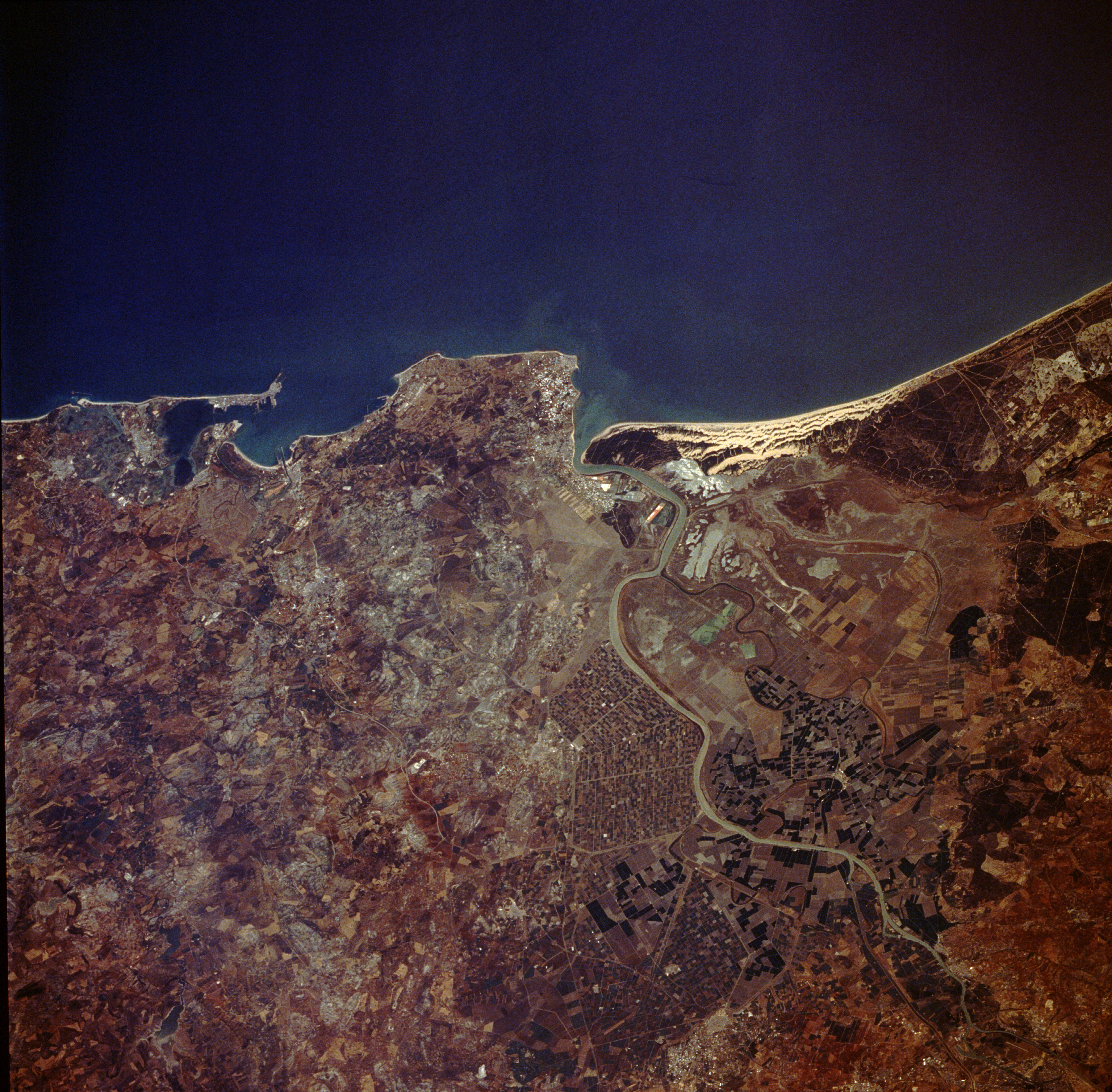
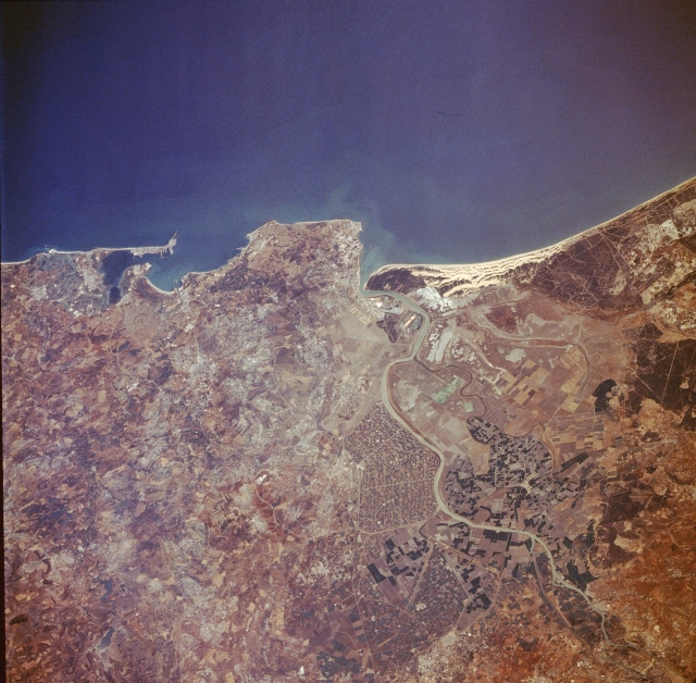
Image Caption: STS028-074-078 Cadiz, Spain August 1989
This photograph shows approximately 60 miles (90 kilometers) of the southwest coast of Spain that fronts the Gulf of Cadiz. Several natural and manmade features are visible when viewing from south to north--the city of Cadiz, a seaport city with a population of approximately 180 000, located at the tip of a very narrow peninsula and surrounded by the Bay of Cadiz; the large runway of Rota Airport near the southern edge of the large angular peninsula, which protrudes into the Gulf of Cadiz; the mouth of the Guadalquivir River by which the city of Seville can be reached by small steamers; and a series of parallel, highly reflective sand dunes north of the mouth of the Guadalquivir River. Inland from the coast, cultivated field patterns are observed. Apparently a substantial amount of the former swampy area along the Guadalquivir River has been converted into productive irrigated farmland, and many canals have been constructed to maximize the available waterflow.
This photograph shows approximately 60 miles (90 kilometers) of the southwest coast of Spain that fronts the Gulf of Cadiz. Several natural and manmade features are visible when viewing from south to north--the city of Cadiz, a seaport city with a population of approximately 180 000, located at the tip of a very narrow peninsula and surrounded by the Bay of Cadiz; the large runway of Rota Airport near the southern edge of the large angular peninsula, which protrudes into the Gulf of Cadiz; the mouth of the Guadalquivir River by which the city of Seville can be reached by small steamers; and a series of parallel, highly reflective sand dunes north of the mouth of the Guadalquivir River. Inland from the coast, cultivated field patterns are observed. Apparently a substantial amount of the former swampy area along the Guadalquivir River has been converted into productive irrigated farmland, and many canals have been constructed to maximize the available waterflow.
