STS028-71-89
| NASA Photo ID | STS028-71-89 |
| Focal Length | 100mm |
| Date taken | 1989.08.08 |
| Time taken | 22:08:20 GMT |
Resolutions offered for this image:
1536 x 1536 pixels 639 x 639 pixels 5700 x 5900 pixels 500 x 518 pixels 640 x 480 pixels
1536 x 1536 pixels 639 x 639 pixels 5700 x 5900 pixels 500 x 518 pixels 640 x 480 pixels
Cloud masks available for this image:
Spacecraft nadir point: 42.0° N, 100.4° W
Photo center point: 41.0° N, 101.0° W
Photo center point by machine learning:
Photo center point: 41.0° N, 101.0° W
Photo center point by machine learning:
Nadir to Photo Center: Southwest
Spacecraft Altitude: 163 nautical miles (302km)
Country or Geographic Name: | USA-NEBRASKA |
Features: | PLATTE RIVER |
| Features Found Using Machine Learning: | |
Cloud Cover Percentage: | 5 (1-10)% |
Sun Elevation Angle: | 40° |
Sun Azimuth: | 255° |
Camera: | Hasselblad |
Focal Length: | 100mm |
Camera Tilt: | 23 degrees |
Format: | 5017: Kodak, natural color positive, Ektachrome, X Professional, ASA 64, standard base |
Film Exposure: | Normal |
| Additional Information | |
| Width | Height | Annotated | Cropped | Purpose | Links |
|---|---|---|---|---|---|
| 1536 pixels | 1536 pixels | No | No | Earth From Space collection | Download Image |
| 639 pixels | 639 pixels | No | No | Earth From Space collection | Download Image |
| 5700 pixels | 5900 pixels | No | No | Download Image | |
| 500 pixels | 518 pixels | No | No | Download Image | |
| 640 pixels | 480 pixels | No | No | Download Image |
Download Packaged File
Download a Google Earth KML for this Image
View photo footprint information
Download a GeoTIFF for this photo
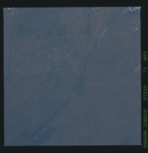
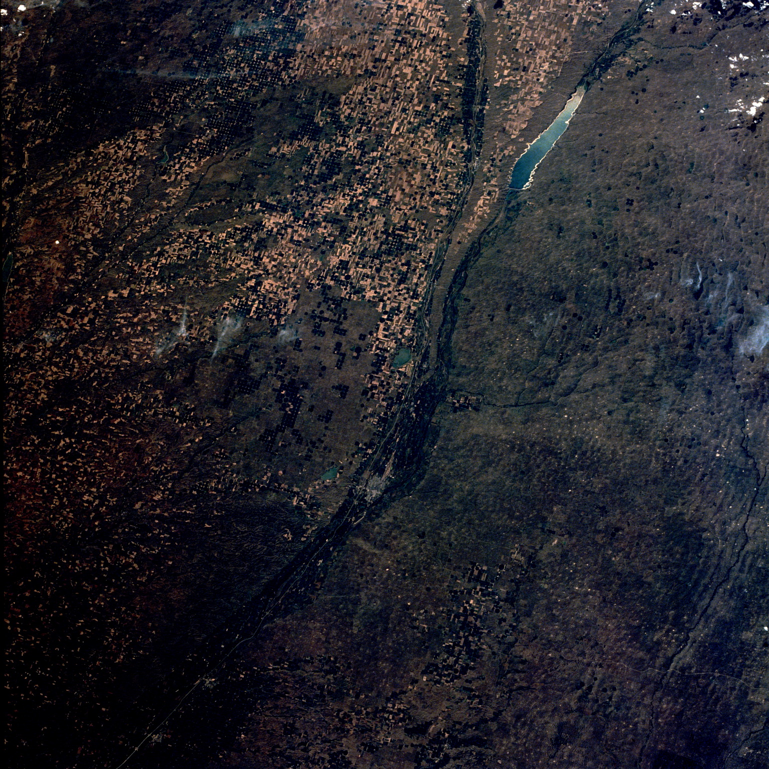
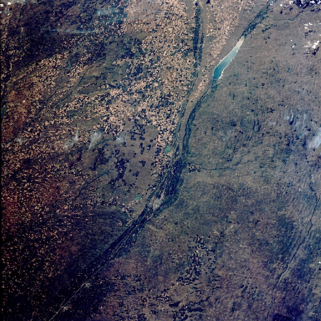
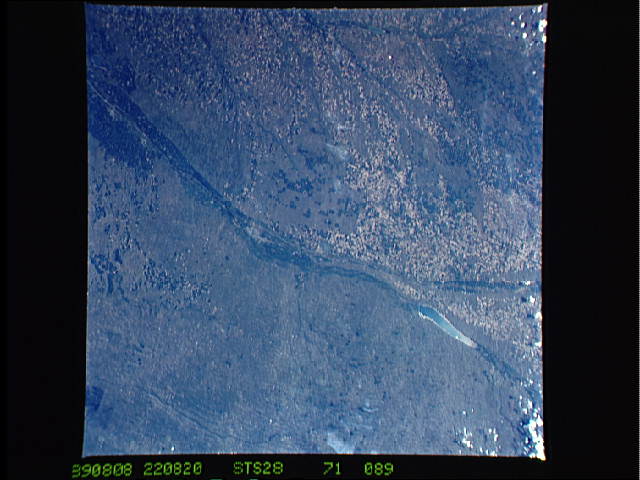
Image Caption: STS028-071-089 North and South Platte Rivers, Nebraska, U.S.A. August 1989
The confluence of two rivers in west-central Nebraska, the North Platte and the South Platte, is revealed near the center of this west-looking, low-oblique photograph. Lake McConaughy on the North Platte River is seen near the northwest corner of the photograph. The river is 680 miles (1095 kilometers) long and originates in the Park Range of northern Colorado. Its waters are used for crop irrigation and grazing livestock in the area from near Guernsey, Wyoming, to below Bridgeport, Nebraska. North of Lake McConaughy and the North Platte River are the Nebraska Sand Hills (visible in the photograph), a maze of grass-covered dunes formed during the last glacial epoch. The South Platte River originates in the Rocky Mountains of Colorado northwest of Denver. After leaving the mountains and reaching the Great Plains, the river becomes a broad, shallow stream. It supplies water for cattle grazing and irrigation of agricultural crops (irrigated field patterns lie south of the river in the photograph). At the confluence of the two rivers near the city of North Platte, the river becomes the Platte and flows eastward 310 miles (500 kilometers) before joining the Missouri River south of Omaha. Much of the Platte River is used for irrigation and the production of hydroelectric power.
The confluence of two rivers in west-central Nebraska, the North Platte and the South Platte, is revealed near the center of this west-looking, low-oblique photograph. Lake McConaughy on the North Platte River is seen near the northwest corner of the photograph. The river is 680 miles (1095 kilometers) long and originates in the Park Range of northern Colorado. Its waters are used for crop irrigation and grazing livestock in the area from near Guernsey, Wyoming, to below Bridgeport, Nebraska. North of Lake McConaughy and the North Platte River are the Nebraska Sand Hills (visible in the photograph), a maze of grass-covered dunes formed during the last glacial epoch. The South Platte River originates in the Rocky Mountains of Colorado northwest of Denver. After leaving the mountains and reaching the Great Plains, the river becomes a broad, shallow stream. It supplies water for cattle grazing and irrigation of agricultural crops (irrigated field patterns lie south of the river in the photograph). At the confluence of the two rivers near the city of North Platte, the river becomes the Platte and flows eastward 310 miles (500 kilometers) before joining the Missouri River south of Omaha. Much of the Platte River is used for irrigation and the production of hydroelectric power.
