STS028-153-20
| NASA Photo ID | STS028-153-20 |
| Focal Length | 90mm |
| Date taken | 1989.08.11 |
| Time taken | 19:27:46 GMT |
Resolutions offered for this image:
640 x 480 pixels
640 x 480 pixels
Cloud masks available for this image:
Spacecraft nadir point: 53.2° N, 100.4° W
Photo center point: 52.5° N, 94.5° W
Photo center point by machine learning:
Photo center point: 52.5° N, 94.5° W
Photo center point by machine learning:
Nadir to Photo Center: East
Spacecraft Altitude: 162 nautical miles (300km)
Country or Geographic Name: | CANADA-O |
Features: | L. WINNIPEG |
| Features Found Using Machine Learning: | |
Cloud Cover Percentage: | 80 (76-100)% |
Sun Elevation Angle: | 51° |
Sun Azimuth: | 196° |
Camera: | Linhof |
Focal Length: | 90mm |
Camera Tilt: | High Oblique |
Format: | 5017: Kodak, natural color positive, Ektachrome, X Professional, ASA 64, standard base |
Film Exposure: | Normal |
| Additional Information | |
| Width | Height | Annotated | Cropped | Purpose | Links |
|---|---|---|---|---|---|
| 640 pixels | 480 pixels | No | No | ISD 1 | Download Image |
Download Packaged File
Download a Google Earth KML for this Image
View photo footprint information
Download a GeoTIFF for this photo
Image Caption:
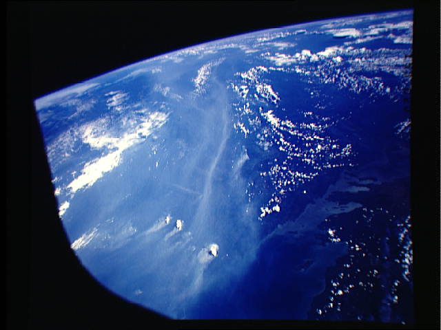
STS028-153-020. This and the next three photographs are put to-
gether to show the point sources and the rather large smoke pall
of the Canadian forest fires of 1989. This first scene [Geocarto
5 (1990>2): 67] was taken from north of Lake Winnipeg looking
southeast. Three very large fires are visible in the foreground
just to the northeast of the north end of Lake Winnipeg. The
smoke pall from these fires and the associated smaller fires can
be seen extending to the horizon, approximately 1300 n. mi. away.
The small cumuli raised by the fires show the primary location of
the firesU heat plumes.
