STS028-151-77
| NASA Photo ID | STS028-151-77 |
| Focal Length | 90mm |
| Date taken | 1989.08.__ |
| Time taken | GMT |
Resolutions offered for this image:
640 x 480 pixels
640 x 480 pixels
Cloud masks available for this image:
Spacecraft nadir point:
Photo center point: 41.5° N, 53.5° E
Photo center point by machine learning:
Photo center point: 41.5° N, 53.5° E
Photo center point by machine learning:
Nadir to Photo Center:
Spacecraft Altitude: nautical miles (0km)
Country or Geographic Name: | TURKMENISTAN |
Features: | KARA-BOGAZ-GOL BAY |
| Features Found Using Machine Learning: | |
Cloud Cover Percentage: | 50 (26-50)% |
Sun Elevation Angle: | ° |
Sun Azimuth: | ° |
Camera: | Linhof |
Focal Length: | 90mm |
Camera Tilt: | Near Vertical |
Format: | QX868: Kodak, natural color positive, Ektachrome QX868(5017 emulsion), ASA 64, thin base |
Film Exposure: | Normal |
| Additional Information | |
| Width | Height | Annotated | Cropped | Purpose | Links |
|---|---|---|---|---|---|
| 640 pixels | 480 pixels | No | No | ISD 1 | Download Image |
Download Packaged File
Download a Google Earth KML for this Image
View photo footprint information
Download a GeoTIFF for this photo
Image Caption:
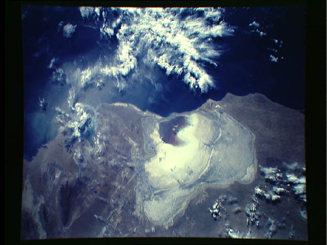
STS028-151-077. By August 1989, the Zaliv Kara-Bogaz-Gol was re-
duced to a small remnant immediately adjacent to the Caspian Sea.
The salinity of the remaining water here is about 300-330 ppt,
and it is highly poisonous to virtually all forms of life includ-
ing the hardy brine shrimp. The decrease of the Zaliv KBG is due
to the decreased water level of the Caspian Sea itself, in turn
associated with increased diversion, for industrial, urban, and
agricultural purposes, of the Ehmba, Ural, and Volga Rivers on
the north end of the Caspian. In the mid-1970s the Soviets built
three dams and support structures across the inlet between the
Caspian and the Zaliv KBG in order to cut it off and reduce the
loss of Caspian Sea water into this evaporative basin. These
structures, like the more famous Southern Pacific causeway across
the Great Salt Lake of Utah, may have been breached or become
porous.
