STS027-152-68
| NASA Photo ID | STS027-152-68 |
| Focal Length | 90mm |
| Date taken | 1988.12.05 |
| Time taken | 04:37:35 GMT |
Resolutions offered for this image:
640 x 480 pixels
640 x 480 pixels
Cloud masks available for this image:
Spacecraft nadir point: 27.8° S, 14.9° E
Photo center point: 25.0° S, 14.5° E
Photo center point by machine learning:
Photo center point: 25.0° S, 14.5° E
Photo center point by machine learning:
Nadir to Photo Center: North
Spacecraft Altitude: 242 nautical miles (448km)
Country or Geographic Name: | NAMIBIA |
Features: | NAMIB DESERT |
| Features Found Using Machine Learning: | |
Cloud Cover Percentage: | 60 (51-75)% |
Sun Elevation Angle: | 7° |
Sun Azimuth: | 111° |
Camera: | Linhof |
Focal Length: | 90mm |
Camera Tilt: | 35 degrees |
Format: | 5017: Kodak, natural color positive, Ektachrome, X Professional, ASA 64, standard base |
Film Exposure: | Normal |
| Additional Information | |
| Width | Height | Annotated | Cropped | Purpose | Links |
|---|---|---|---|---|---|
| 640 pixels | 480 pixels | No | No | ISD 1 | Download Image |
Download Packaged File
Download a Google Earth KML for this Image
View photo footprint information
Download a GeoTIFF for this photo
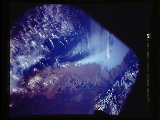
Image Caption:
Coastline as "axis of aridity" - stratus and cumulus
clouds T23
This oblique, north-looking photo shows very well the uniqueness
of the Namib Desert climate: Upwelling of cold water right at
the coast line causes local atmospheric stability and intense
drying up to 150 km inland, including the great Namib Sand Sea.
Upwelling also causes fog banks of stratus cloud to form (upper
center). Fogs are the major source of regular water for numerous
desert organisms. Rain-bearing cumulus clouds only develop over
the high plateau (top right) and out over the ocean (bottom left)
but almost never form over the Namib itself. This photograph was
taken almost exactly 24 hours after S27-151-11, at dawn. (S27-
152-068)
