STS027-152-55
| NASA Photo ID | STS027-152-55 |
| Focal Length | 90mm |
| Date taken | 1988.12.05 |
| Time taken | 00:16:06 GMT |
Resolutions offered for this image:
640 x 480 pixels
640 x 480 pixels
Cloud masks available for this image:
Spacecraft nadir point: 32.6° N, 125.5° E
Photo center point: 37.5° N, 127.5° E
Photo center point by machine learning:
Photo center point: 37.5° N, 127.5° E
Photo center point by machine learning:
Nadir to Photo Center: North
Spacecraft Altitude: 239 nautical miles (443km)
Country or Geographic Name: | SOUTH KOREA |
Features: | PAN-KOREA PENINSULA |
| Features Found Using Machine Learning: | |
Cloud Cover Percentage: | 50 (26-50)% |
Sun Elevation Angle: | 18° |
Sun Azimuth: | 134° |
Camera: | Linhof |
Focal Length: | 90mm |
Camera Tilt: | High Oblique |
Format: | 5017: Kodak, natural color positive, Ektachrome, X Professional, ASA 64, standard base |
Film Exposure: | Normal |
| Additional Information | |
| Width | Height | Annotated | Cropped | Purpose | Links |
|---|---|---|---|---|---|
| 640 pixels | 480 pixels | No | No | ISD 1 | Download Image |
Download Packaged File
Download a Google Earth KML for this Image
View photo footprint information
Download a GeoTIFF for this photo
Image Caption:
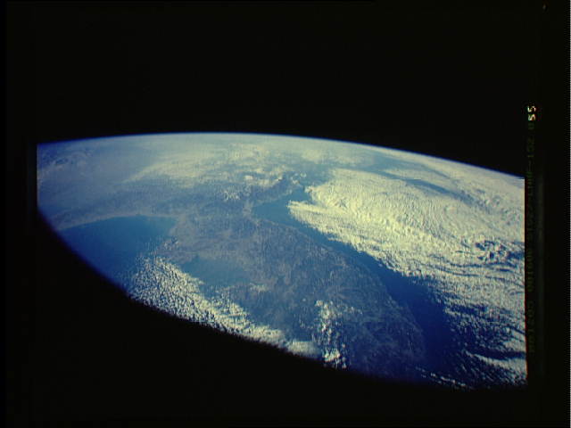
Korean Peninsula
A synoptic, oblique view of the Koreas was taken on STS-27. Coa-
stal fog often drapes the rocky western shore due to upwelling of
cold water along the rocky coast. (S27-152-55)
Korean Peninsula
A synoptic, oblique view of the Koreas was taken on STS-27. Coa-
stal fog often drapes the rocky western shore due to upwelling of
cold water along the rocky coast. (S27-152-55)
