STS026-46-6
| NASA Photo ID | STS026-46-6 |
| Focal Length | 100mm |
| Date taken | 1988.10.03 |
| Time taken | 08:59:48 GMT |
Resolutions offered for this image:
5700 x 5900 pixels 500 x 518 pixels 640 x 480 pixels 2620 x 2545 pixels 437 x 440 pixels 884 x 867 pixels
5700 x 5900 pixels 500 x 518 pixels 640 x 480 pixels 2620 x 2545 pixels 437 x 440 pixels 884 x 867 pixels


Cloud masks available for this image:
Spacecraft nadir point: 22.4° N, 30.7° E
Photo center point: 23.0° N, 32.5° E
Photo center point by machine learning:
Photo center point: 23.0° N, 32.5° E
Photo center point by machine learning:
Nadir to Photo Center: East
Spacecraft Altitude: 172 nautical miles (319km)
Country or Geographic Name: | EGYPT |
Features: | NILE R, LAKE NASSER |
| Features Found Using Machine Learning: | |
Cloud Cover Percentage: | 0 (no clouds present) |
Sun Elevation Angle: | 61° |
Sun Azimuth: | 155° |
Camera: | Hasselblad |
Focal Length: | 100mm |
Camera Tilt: | 34 degrees |
Format: | 5017: Kodak, natural color positive, Ektachrome, X Professional, ASA 64, standard base |
Film Exposure: | Normal |
| Additional Information | |
| Width | Height | Annotated | Cropped | Purpose | Links |
|---|---|---|---|---|---|
| 5700 pixels | 5900 pixels | No | No | Download Image | |
| 500 pixels | 518 pixels | No | No | Download Image | |
| 640 pixels | 480 pixels | No | No | Download Image | |
| 2620 pixels | 2545 pixels | No | No | Download Image | |
| 437 pixels | 440 pixels | Download Image | |||
| 884 pixels | 867 pixels | Download Image |
Download Packaged File
Download a Google Earth KML for this Image
View photo footprint information
Download a GeoTIFF for this photo
Image Caption:
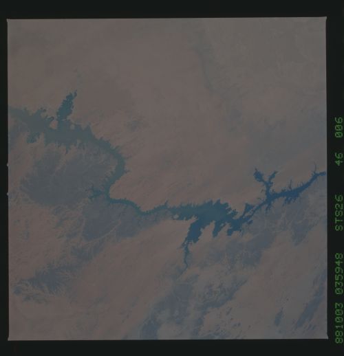
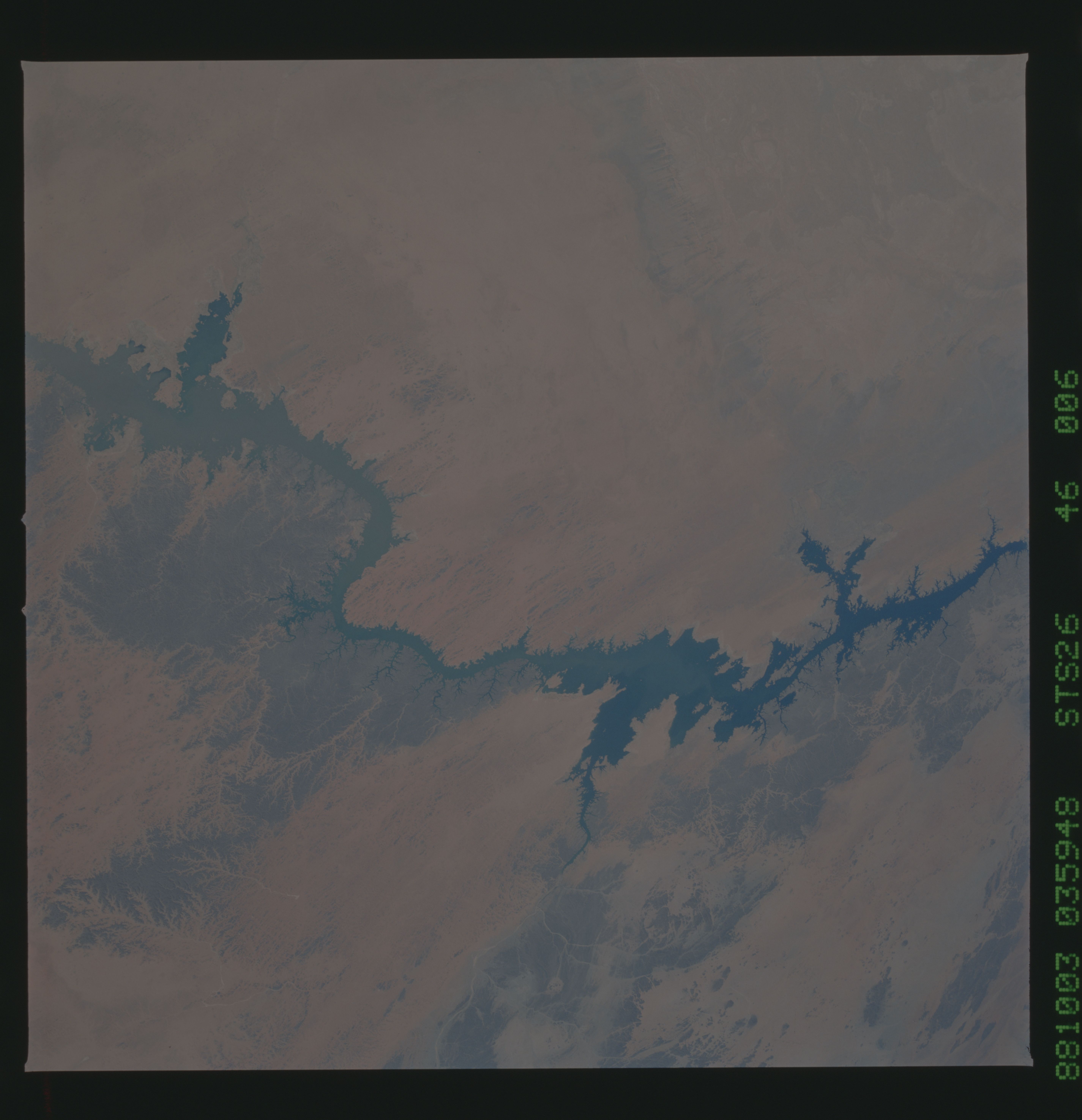
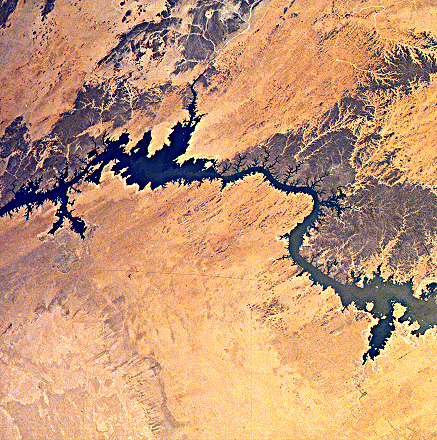
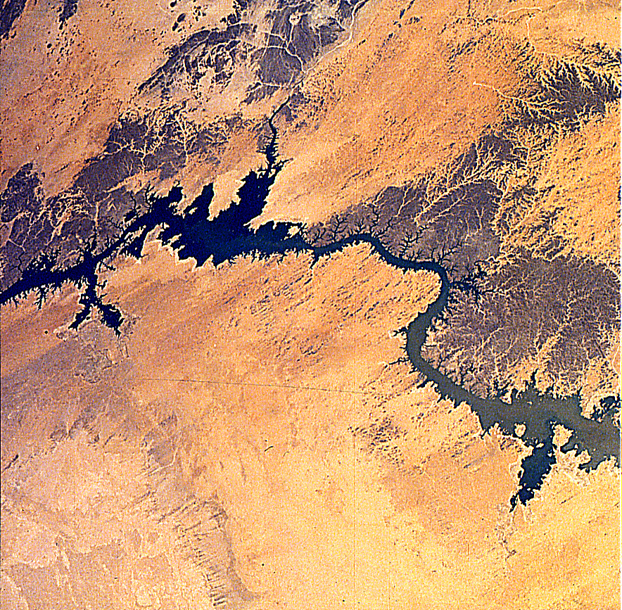
STS026-46-006 - A tongue of silty flood water from the south is
making its way through Lake Nasser in this astronaut photograph
of Egypt. The leading edge of the muddy flood water can be seen
here at approximately 23! N, 32.5! E, still about 80 n. mi. south
of the Aswan Dam. Although very heavy summer rains occurred
along the Blue Nile in Ethiopia and the White Nile in Sudan, Lake
Nasser remains as low as it has been seen during the Space Shut-
tle era (1981-88). Large areas of lake bottom remain exposed as
white-to-gray rims around the arms of the lake, especially to-
wards the north.
