STS026-40-56
| NASA Photo ID | STS026-40-56 |
| Focal Length | 250mm |
| Date taken | 1988.10.02 |
| Time taken | 21:15:45 GMT |
Resolutions offered for this image:
5337 x 5285 pixels 639 x 633 pixels 5700 x 5900 pixels 500 x 518 pixels 640 x 480 pixels
5337 x 5285 pixels 639 x 633 pixels 5700 x 5900 pixels 500 x 518 pixels 640 x 480 pixels


Cloud masks available for this image:
Spacecraft nadir point: 14.7° S, 70.9° W
Photo center point: 16.0° S, 71.5° W
Photo center point by machine learning:
Photo center point: 16.0° S, 71.5° W
Photo center point by machine learning:
Nadir to Photo Center: South
Spacecraft Altitude: 163 nautical miles (302km)
Country or Geographic Name: | PERU |
Features: | NEV. CHACHANI, VOLCANOES |
| Features Found Using Machine Learning: | |
Cloud Cover Percentage: | 0 (no clouds present) |
Sun Elevation Angle: | 19° |
Sun Azimuth: | 271° |
Camera: | Hasselblad |
Focal Length: | 250mm |
Camera Tilt: | 28 degrees |
Format: | 5017: Kodak, natural color positive, Ektachrome, X Professional, ASA 64, standard base |
Film Exposure: | Normal |
| Additional Information | |
| Width | Height | Annotated | Cropped | Purpose | Links |
|---|---|---|---|---|---|
| 5337 pixels | 5285 pixels | No | No | Earth From Space collection | Download Image |
| 639 pixels | 633 pixels | No | No | Earth From Space collection | Download Image |
| 5700 pixels | 5900 pixels | No | No | Download Image | |
| 500 pixels | 518 pixels | No | No | Download Image | |
| 640 pixels | 480 pixels | No | No | Download Image |
Download Packaged File
Download a Google Earth KML for this Image
View photo footprint information
Download a GeoTIFF for this photo
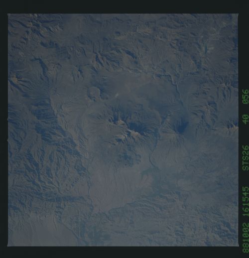
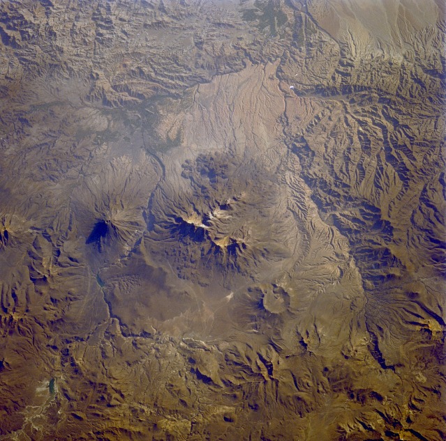
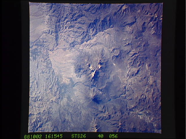
Image Caption: STS026-040-056 El Misti Volcano, Arequipa Area, Peru October 1988
Volcanoes, mountains, and deeply entrenched river valleys appear in this near-vertical photograph of the Arequipa region of southern Peru. The large, multipeaked, snow-capped volcanic structure ascending more than 19 870 feet (6055 meters) above sea level (center of the photograph) is Nevada de Chachani, directly north of which is the large caldera of an unidentified volcano. Southeast of Nevada de Chachani and across the Chili River valley stands El Misti Volcano, a dormant volcano that last erupted in 1870. El Misti (usually snow-capped, but not in this photograph), a cone volcano widely recognized in the Inca religion, has provided inspiration for Peruvian legends and poetry. El Misti rises 19 098 feet (5825 meters) above sea level. Arequipa, one of Peru's larger cities with a population of more than 100 000, sits along the western flank at the foot of El Misti. The city is located on a narrow plain and provides goods and services to southern Peru and northern Chile. Chief exports of this region are leather goods, textiles, foodstuffs, and wool.
Volcanoes, mountains, and deeply entrenched river valleys appear in this near-vertical photograph of the Arequipa region of southern Peru. The large, multipeaked, snow-capped volcanic structure ascending more than 19 870 feet (6055 meters) above sea level (center of the photograph) is Nevada de Chachani, directly north of which is the large caldera of an unidentified volcano. Southeast of Nevada de Chachani and across the Chili River valley stands El Misti Volcano, a dormant volcano that last erupted in 1870. El Misti (usually snow-capped, but not in this photograph), a cone volcano widely recognized in the Inca religion, has provided inspiration for Peruvian legends and poetry. El Misti rises 19 098 feet (5825 meters) above sea level. Arequipa, one of Peru's larger cities with a population of more than 100 000, sits along the western flank at the foot of El Misti. The city is located on a narrow plain and provides goods and services to southern Peru and northern Chile. Chief exports of this region are leather goods, textiles, foodstuffs, and wool.
