STS026-38-14T
| NASA Photo ID | STS026-38-14T |
| Focal Length | 100mm |
| Date taken | 1988.09.30 |
| Time taken | GMT |


Cloud masks available for this image:
Spacecraft nadir point:
Photo center point:
Photo center point by machine learning:
Photo center point:
Photo center point by machine learning:
Nadir to Photo Center:
Spacecraft Altitude: nautical miles (0km)
Camera: | Hasselblad |
Focal Length: | 100mm |
Camera Tilt: | High Oblique |
Format: | 5017: Kodak, natural color positive, Ektachrome, X Professional, ASA 64, standard base |
Film Exposure: | Normal |
| Additional Information | |
| Width | Height | Annotated | Cropped | Purpose | Links |
|---|---|---|---|---|---|
| 5700 pixels | 5900 pixels | No | No | Download Image | |
| 500 pixels | 518 pixels | No | No | Download Image | |
| 640 pixels | 480 pixels | No | No | Download Image |
Download Packaged File
Download a Google Earth KML for this Image
View photo footprint information
Download a GeoTIFF for this photo
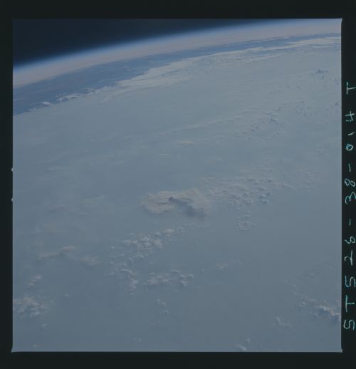
Image Caption: This oblique photograph was taken during Space Shuttle Mission STS-26 (August 1988). The Orbiter nadir position at the time of exposure was approximately 8S 63W, over northern Rondonia State. The altitude was 164 nautical miles. The view is to the WNW across Rondonia and Acre States of Brazil, Northern Bolivia, and ending in the Peruvian Amazon in the upper right. The Andes Mountains of Peru/Ecuador in the upper right are at approximately 2S 78W. The major forest fire plume S1 in the center is approximately halfway between Porto Velho, Rondonia, and Rio Branco, Acre. The are within this view is trapezoidal, measuring some 10 of latitude by 15 of longitude. NASA Photograph. L = Land area. S (1,2,3,4) = smoke pall with various texture classes. C = clouds.
