STS026-34-74
| NASA Photo ID | STS026-34-74 |
| Focal Length | 250mm |
| Date taken | 1988.__.__ |
| Time taken | GMT |

Cloud masks available for this image:
Spacecraft nadir point:
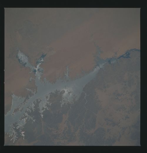
Photo center point: 23.5° N, 33.0° E
Photo center point by machine learning:
Photo center point: 23.5° N, 33.0° E
Photo center point by machine learning:
Nadir to Photo Center:
Spacecraft Altitude: nautical miles (0km)
Country or Geographic Name: | EGYPT |
Features: | LAKE NASSER |
| Features Found Using Machine Learning: | |
Cloud Cover Percentage: | 0 (no clouds present) |
Sun Elevation Angle: | ° |
Sun Azimuth: | ° |
Camera: | Hasselblad |
Focal Length: | 250mm |
Camera Tilt: | Near Vertical |
Format: | 5017: Kodak, natural color positive, Ektachrome, X Professional, ASA 64, standard base |
Film Exposure: | Normal |
| Additional Information | |
| Width | Height | Annotated | Cropped | Purpose | Links |
|---|---|---|---|---|---|
| 5700 pixels | 5900 pixels | No | No | Download Image | |
| 500 pixels | 518 pixels | No | No | Download Image | |
| 640 pixels | 480 pixels | No | No | Download Image |
Download Packaged File
Download a Google Earth KML for this Image
View photo footprint information
Download a GeoTIFF for this photo
Image Caption: The Aswan Dam on the Nile River created the 500 kilometer long reservoir, seen here in sunglint. Lake Nassar (23.5N, 33.0E) was designed to control the devestating floods and alleviate the famine-producing droughts which have plagued the region for millenia. In Nov 81, as the lake was nearing capacity, drought conditions lowered the water level by about 30 meters which can clearly be seen as silt depositions on the receding eastern shoreline.
