STS026-31-88
| NASA Photo ID | STS026-31-88 |
| Focal Length | 100mm |
| Date taken | 1988.09.29 |
| Time taken | 23:21:31 GMT |

Cloud masks available for this image:
Spacecraft nadir point: 24.7° N, 164.4° W
Photo center point: 24.0° N, 165.5° W
Photo center point by machine learning:
Photo center point: 24.0° N, 165.5° W
Photo center point by machine learning:
Nadir to Photo Center: Southwest
Spacecraft Altitude: 167 nautical miles (309km)
Country or Geographic Name: | USA-HAWAII |
Features: | FRENCH FRIGATE SHOALS, COL. CELLS |
| Features Found Using Machine Learning: | |
Cloud Cover Percentage: | 20 (11-25)% |
Sun Elevation Angle: | 61° |
Sun Azimuth: | 197° |
Camera: | Hasselblad |
Focal Length: | 100mm |
Camera Tilt: | 25 degrees |
Format: | 5017: Kodak, natural color positive, Ektachrome, X Professional, ASA 64, standard base |
Film Exposure: | Normal |
| Additional Information | |
| Width | Height | Annotated | Cropped | Purpose | Links |
|---|---|---|---|---|---|
| 5700 pixels | 5900 pixels | No | No | Download Image | |
| 500 pixels | 518 pixels | No | No | Download Image | |
| 640 pixels | 480 pixels | No | No | Download Image |
Download Packaged File
Download a Google Earth KML for this Image
View photo footprint information
Download a GeoTIFF for this photo
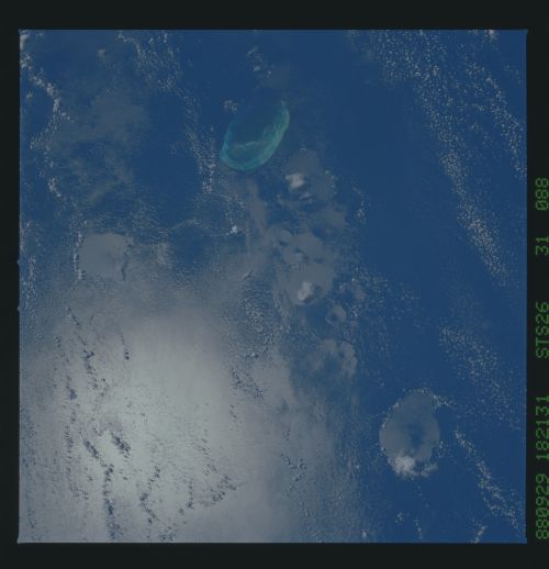
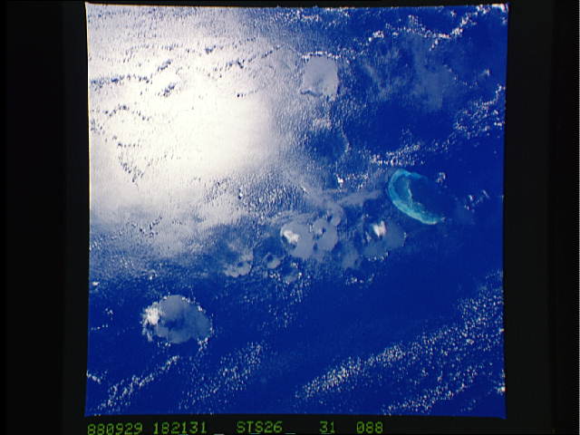
Image Caption: Collapsing Cumulus off French Frigate Shoals
French Frigate Shoals is a remnant coral atoll on a volcanic
cone that is part of the Hawaiian Archipelago. The circular
patches in the ocean are caused by mature storm convection
cells collapsing and producing strong downdrafts. The air
rushes down in cylindrical masses, creating shallow con-
shaped impressions on the water surface. It is unusual to
find so many of different sizes grouped together; here they
range in size from 5 to 25 km across. It has been estimated
that such water surface impressions last no more than 10 to
30 minutes. Taken from STS-26 (Sep 88) with a 100 mm lens.
