STS008-33-993
| NASA Photo ID | STS008-33-993 |
| Focal Length | 100mm |
| Date taken | 1983.__.__ |
| Time taken | GMT |
Resolutions offered for this image:
540 x 474 pixels 4393 x 4600 pixels 478 x 500 pixels 640 x 480 pixels 400 x 351 pixels
540 x 474 pixels 4393 x 4600 pixels 478 x 500 pixels 640 x 480 pixels 400 x 351 pixels


Cloud masks available for this image:
Spacecraft nadir point:
Photo center point: 18.0° S, 25.0° E
Photo center point by machine learning:
Photo center point: 18.0° S, 25.0° E
Photo center point by machine learning:
Nadir to Photo Center:
Spacecraft Altitude: nautical miles (0km)
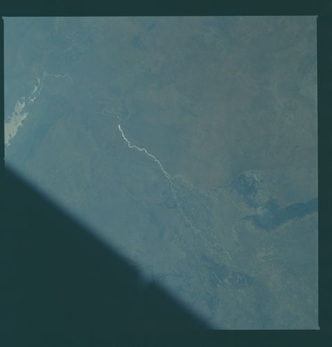
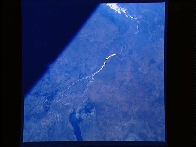
Country or Geographic Name: | BOTSWANA |
Features: | ZAMBEZI & CHOBE RIVER |
| Features Found Using Machine Learning: | |
Cloud Cover Percentage: | 0 (no clouds present) |
Sun Elevation Angle: | ° |
Sun Azimuth: | ° |
Camera: | Hasselblad |
Focal Length: | 100mm |
Camera Tilt: | Low Oblique |
Format: | 6017: Kodak Ektachrome 64, 220 Roll Format |
Film Exposure: | Normal |
| Additional Information | |
| Width | Height | Annotated | Cropped | Purpose | Links |
|---|---|---|---|---|---|
| 540 pixels | 474 pixels | Yes | Yes | Earth From Space collection | Download Image |
| 4393 pixels | 4600 pixels | No | No | Download Image | |
| 478 pixels | 500 pixels | No | No | Download Image | |
| 640 pixels | 480 pixels | No | No | Download Image | |
| 400 pixels | 351 pixels | Yes | Yes | Photographic Highlights | Download Image |
Download Packaged File
Download a Google Earth KML for this Image
View photo footprint information
Download a GeoTIFF for this photo
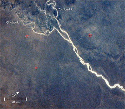
Image Caption: At the junction of the Chobe and Zambezi Rivers, Botswana, increasing elephant populations are having large impacts on local vegetation. Scientists working in the region used spectral analysis of an astronaut photograph digitized from film to identify areas where woodland vegetation had been heavily damaged by the elephants. The technique used the analysis of texture of the red band (or channel) in the image. In the image above, the natural color photo has been combined with a texture analysis of the red band. The lighter colored areas near the labels a, b and c represent the areas with the heaviest elephant damage. Field teams working on the ground verified the presence of damage.
This image is one of the examples of the applications of astronaut photography to conservation biology presented in a paper by Robinson et al. in the August 2001 issue of the scientific journal Conservation Biology. The paper is part of a special section on "Contributions of Remote Sensing to Biodiversity Conservation" (//www.conbio.org/scb/Services/Tips/2001-4-August.cfm) featuring a number of different NASA-sponsored studies.
This image is one of the examples of the applications of astronaut photography to conservation biology presented in a paper by Robinson et al. in the August 2001 issue of the scientific journal Conservation Biology. The paper is part of a special section on "Contributions of Remote Sensing to Biodiversity Conservation" (//www.conbio.org/scb/Services/Tips/2001-4-August.cfm) featuring a number of different NASA-sponsored studies.
