STS007-22-1141
| NASA Photo ID | STS007-22-1141 |
| Focal Length | 250mm |
| Date taken | 1983.06.__ |
| Time taken | GMT |
Resolutions offered for this image:
640 x 480 pixels
640 x 480 pixels
Cloud masks available for this image:
Spacecraft nadir point:
Photo center point: 20.0° N, 155.5° W
Photo center point by machine learning:
Photo center point: 20.0° N, 155.5° W
Photo center point by machine learning:
Nadir to Photo Center:
Spacecraft Altitude: nautical miles (0km)
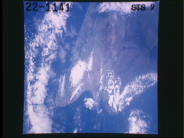
Country or Geographic Name: | USA-HAWAII |
Features: | HAWAII ISLAND, MAUNA LOA |
| Features Found Using Machine Learning: | |
Cloud Cover Percentage: | 30 (26-50)% |
Sun Elevation Angle: | ° |
Sun Azimuth: | ° |
Camera: | Hasselblad |
Focal Length: | 250mm |
Camera Tilt: | Low Oblique |
Format: | 5017: Kodak, natural color positive, Ektachrome, X Professional, ASA 64, standard base |
Film Exposure: | Normal |
| Additional Information | |
| Width | Height | Annotated | Cropped | Purpose | Links |
|---|---|---|---|---|---|
| 640 pixels | 480 pixels | No | No | ISD 1 | Download Image |
Download Packaged File
Download a Google Earth KML for this Image
View photo footprint information
Download a GeoTIFF for this photo
Image Caption: This single photo covers almost all of the big island of Hawaii (19.5N, 155.5E) in the Hawaiian Archipelago. The active Kilauea Volcano and lava flow is under clouds and hardly visible at the lower right edge but the Mauna Loa volcano crater and its older lava flow is at the bottom center. The Kona Coast, that produces the only coffee grown in the United States, is to the left. Mauna Kea is the extinct volcano and lava flow in the right center.
