STS005-39-1048
| NASA Photo ID | STS005-39-1048 |
| Focal Length | 100mm |
| Date taken | 1982.11.__ |
| Time taken | GMT |

Cloud masks available for this image:
Spacecraft nadir point:
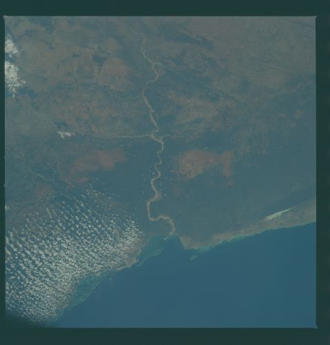
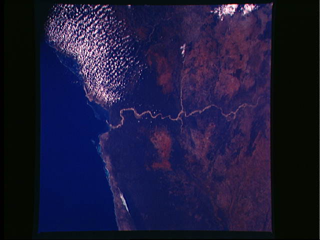
Photo center point: 23.5° S, 44.1° E
Photo center point by machine learning:
Photo center point: 23.5° S, 44.1° E
Photo center point by machine learning:
Nadir to Photo Center:
Spacecraft Altitude: nautical miles (0km)
Country or Geographic Name: | MADAGASCAR |
Features: | ONILAHY RIVER |
| Features Found Using Machine Learning: | |
Cloud Cover Percentage: | 15 (11-25)% |
Sun Elevation Angle: | ° |
Sun Azimuth: | ° |
Camera: | Hasselblad |
Focal Length: | 100mm |
Camera Tilt: | Low Oblique |
Format: | 5017: Kodak, natural color positive, Ektachrome, X Professional, ASA 64, standard base |
Film Exposure: | Under Exposed |
| Additional Information | |
| Width | Height | Annotated | Cropped | Purpose | Links |
|---|---|---|---|---|---|
| 4393 pixels | 4600 pixels | No | No | Download Image | |
| 478 pixels | 500 pixels | No | No | Download Image | |
| 640 pixels | 480 pixels | No | No | Download Image |
Download Packaged File
Download a Google Earth KML for this Image
View photo footprint information
Download a GeoTIFF for this photo
Image Caption: Near the southern tip of Madagascar, the Onilahy River (23.5S, 44E) drains a near barren landscape, the result of rapid deforestation for quick profits from the lumber industry with no regard to the environmental impact. At the turn of the century, the island was a lush tropical paradise with about 90 percent of the surface forested. Now, at the close of the century, only about 10 percent of the forests remain in inaccessible rugged terrain.
