STS004-38-871
| NASA Photo ID | STS004-38-871 |
| Focal Length | 100mm |
| Date taken | 1982.__.__ |
| Time taken | GMT |


Cloud masks available for this image:
Spacecraft nadir point:
Photo center point: 29.3° N, 113.4° W
Photo center point by machine learning:
Photo center point: 29.3° N, 113.4° W
Photo center point by machine learning:
Nadir to Photo Center:
Spacecraft Altitude: nautical miles (0km)
Country or Geographic Name: | MEXICO |
Features: | ANGEL GUARDA, TIBURON IS |
| Features Found Using Machine Learning: | |
Cloud Cover Percentage: | 10 (1-10)% |
Sun Elevation Angle: | ° |
Sun Azimuth: | ° |
Camera: | Hasselblad |
Focal Length: | 100mm |
Camera Tilt: | Low Oblique |
Format: | 2448: Fine Grain Aerochrome II color-reversal camera film, 70mm, process EA-5 |
Film Exposure: | Normal |
| Additional Information | |
| Width | Height | Annotated | Cropped | Purpose | Links |
|---|---|---|---|---|---|
| 4393 pixels | 4600 pixels | No | No | Download Image | |
| 478 pixels | 500 pixels | No | No | Download Image | |
| 640 pixels | 480 pixels | No | No | Download Image |
Download Packaged File
Download a Google Earth KML for this Image
View photo footprint information
Download a GeoTIFF for this photo
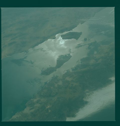
Image Caption: Sunglint on the water's surface reveals the complex pattern of currents in the Gulf of California in the vicinity of Tiburon and Angel de la Guarda Islands (29.0N, 113.0W). Mexico's state of Sonora and the Sonora Desert is on the mainland and the state of Baja California consists of the entire peninsula. The Pacific Ocean is under the coastal cloud cover on the Baja peninsula.
