STS004-37-715
| NASA Photo ID | STS004-37-715 |
| Focal Length | 100mm |
| Date taken | 1982.__.__ |
| Time taken | GMT |

Cloud masks available for this image:
Spacecraft nadir point:
Photo center point: 26.0° N, 56.0° E
Photo center point by machine learning:
Photo center point: 26.0° N, 56.0° E
Photo center point by machine learning:
Nadir to Photo Center:
Spacecraft Altitude: nautical miles (0km)
Country or Geographic Name: | UNITED ARAB EMIRATES |
Features: | IRAN/PERSIAN GULF STRUCT |
| Features Found Using Machine Learning: | |
Cloud Cover Percentage: | 5 (1-10)% |
Sun Elevation Angle: | ° |
Sun Azimuth: | ° |
Camera: | Hasselblad |
Focal Length: | 100mm |
Camera Tilt: | Low Oblique |
Format: | 2448: Fine Grain Aerochrome II color-reversal camera film, 70mm, process EA-5 |
Film Exposure: | Normal |
| Additional Information | |
| Width | Height | Annotated | Cropped | Purpose | Links |
|---|---|---|---|---|---|
| 4393 pixels | 4600 pixels | No | No | Download Image | |
| 478 pixels | 500 pixels | No | No | Download Image | |
| 640 pixels | 480 pixels | No | No | Download Image |
Download Packaged File
Download a Google Earth KML for this Image
View photo footprint information
Download a GeoTIFF for this photo
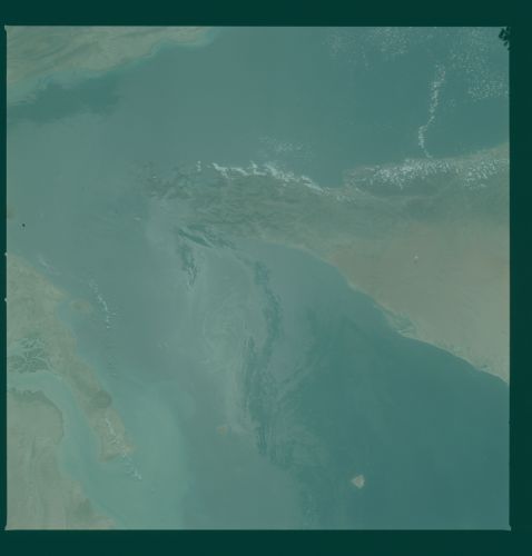
Image Caption: Taken 4 orbits later (approx. 6 hours) than the above slide.
Note the shift of the sunglint.
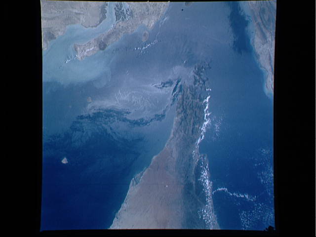
Here the waters of the Persian Gulf (left) meet those of the
Gulf of Oman (right). An eddy as well as ship wakes are
visible in the glint of reflected sunlight on the water
surface. Taken with a 100 mm lens (approx. 90 nm on a side).
Resolution is approx. 250 feet.
( Small sea breeze clouds outline the eastern shore of
Muscat and the United Arab emirates. Small irregularly
shaped islands at the northern end of the Oman Mountains
suggest that the tip of the peninsula has subsided,
partially submerging the mountain chain.
Over the last 10 million years, northward movement of
the small continental plate that compromises the Arabian
Peninsula has crushed and wrinkled the edge of the Asian
continental plate. These wrinkles are visible today as the
folded Zagros Mountain Range (upper right corner). This
mountain-building activity has also distributed a thick 600-
million year old salt deposit buried deep beneath the
sedimentary cover at the edge of the Asian plate. Under
great pressure salt is very mobile, behaving like material
with the consistency of toothpaste. The result has been the
slow upward movement of pillars of salt to produce salt
domes (dark circular patterns in the upper left). The
upturned sedimentary layers that fringe the salt domes serve
as ideal traps for migrating hydrocarbons and account for
the incredible oil accumulates of the region. This photo
was taken in June 1982 with a Hasselblad 70-mm camera and
100-mm lens.)
Note the shift of the sunglint.
Here the waters of the Persian Gulf (left) meet those of the
Gulf of Oman (right). An eddy as well as ship wakes are
visible in the glint of reflected sunlight on the water
surface. Taken with a 100 mm lens (approx. 90 nm on a side).
Resolution is approx. 250 feet.
( Small sea breeze clouds outline the eastern shore of
Muscat and the United Arab emirates. Small irregularly
shaped islands at the northern end of the Oman Mountains
suggest that the tip of the peninsula has subsided,
partially submerging the mountain chain.
Over the last 10 million years, northward movement of
the small continental plate that compromises the Arabian
Peninsula has crushed and wrinkled the edge of the Asian
continental plate. These wrinkles are visible today as the
folded Zagros Mountain Range (upper right corner). This
mountain-building activity has also distributed a thick 600-
million year old salt deposit buried deep beneath the
sedimentary cover at the edge of the Asian plate. Under
great pressure salt is very mobile, behaving like material
with the consistency of toothpaste. The result has been the
slow upward movement of pillars of salt to produce salt
domes (dark circular patterns in the upper left). The
upturned sedimentary layers that fringe the salt domes serve
as ideal traps for migrating hydrocarbons and account for
the incredible oil accumulates of the region. This photo
was taken in June 1982 with a Hasselblad 70-mm camera and
100-mm lens.)
