STS002-9-419

| NASA Photo ID | STS002-9-419 |
| Focal Length | 100mm |
| Date taken | 1981.11.__ |
| Time taken | GMT |

Cloud masks available for this image:
Spacecraft nadir point:
Photo center point: 1.0° N, 34.5° E
Photo center point by machine learning:
Photo center point: 1.0° N, 34.5° E
Photo center point by machine learning:
Nadir to Photo Center:
Spacecraft Altitude: nautical miles (0km)
Country or Geographic Name: | KENYA |
Features: | MOUNT ELGON |
| Features Found Using Machine Learning: | |
Cloud Cover Percentage: | 5 (1-10)% |
Sun Elevation Angle: | ° |
Sun Azimuth: | ° |
Camera: | Hasselblad |
Focal Length: | 100mm |
Camera Tilt: | Near Vertical |
Format: | QX824: Kodak Ektachrome 64 |
Film Exposure: | Normal |
| Additional Information | |
| Width | Height | Annotated | Cropped | Purpose | Links |
|---|---|---|---|---|---|
| 4393 pixels | 4600 pixels | No | No | Download Image | |
| 478 pixels | 500 pixels | No | No | Download Image | |
| 640 pixels | 480 pixels | No | No | Download Image |
Download Packaged File
Download a Google Earth KML for this Image
View photo footprint information
Download a GeoTIFF for this photo
Image Caption:
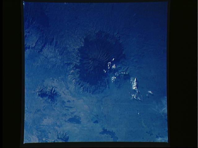
Mount Elgon Volcano T34
The extinct Mount Elgon Volcano is shown in these two views using
different lenses. Also visible in the upper left view are the
northern portion of Lake Victoria (1), the eastern portion of
Lake Kyoga (2), Lake Bisina (3), the Turkwel River (4), and the
Cherangan Hills (5). Mt. Elgon has a very broad base up to 80 km
across covering an area of 3,200 sq. km. The crater at the summit
is 8 km in diameter and 600 meters deep. The highest point on the
rim of the crater reaches 4,321 meters, making the mountain one
of the highest volcanoes in the world. Mount Elgon last erupted
more than 3 million years ago. Since that time the immense accu-
mulations of volcanic ash and cinders have decomposed to form
deep, rich soil. Precipitation in the region is ample. Two
rivers flowing down the slopes of the mountain have their sources
in the marshy crater. Farming flourishes on the lower slopes,
especially in the western valleys. The summit is still occasion-
ally dusted by snow. (S27-35-005, S02-09-419)
