SL3-34-302
| NASA Photo ID | SL3-34-302 |
| Focal Length | 152mm |
| Date taken | 1973.09.07 |
| Time taken | 20:47:20 GMT |

Cloud masks available for this image:
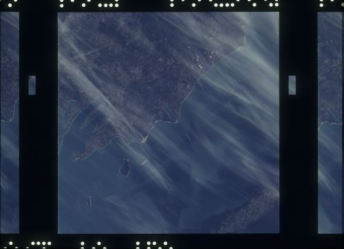
Spacecraft nadir point: 44.7° N, 86.2° W
Photo center point: 44.7° N, 86.2° W
Photo center point by machine learning:
Photo center point: 44.7° N, 86.2° W
Photo center point by machine learning:
Nadir to Photo Center:
Spacecraft Altitude: 232 nautical miles (430km)
Country or Geographic Name: | |
Features: | WISCONSIN, MICHIGAN, LAKE MICHIGAN, TRAVERSE CITY |
| Features Found Using Machine Learning: | |
Cloud Cover Percentage: | 60 (51-75)% |
Sun Elevation Angle: | ° |
Sun Azimuth: | ° |
Camera: | Skylab Multispectral (S190A) |
Focal Length: | 152mm |
Camera Tilt: | 0 degrees |
Format: | SO356: Unknown SkyLab |
Film Exposure: | |
| Additional Information | |
| Width | Height | Annotated | Cropped | Purpose | Links |
|---|---|---|---|---|---|
| 6830 pixels | 4937 pixels | No | No | Download Image | |
| 500 pixels | 361 pixels | No | No | Download Image |
Download Packaged File
Download a Google Earth KML for this Image
View photo footprint information
Download a GeoTIFF for this photo
Image Caption: A vertical view of the Lake Michigan coastal area of northern Michigan as photographed from Earth orbit by one of the Itek-furnished S190-A Multispectral Photographic Facility Experiment aboard the Skylab space station. The view extends across Lake Michigan to Wisconsin's Green Bay. The two fingered body of water is Traverse Bay. Traverse City, Cadillac and Manistee can be seen in this photograph.
