NM23-776-834
| NASA Photo ID | NM23-776-834 |
| Focal Length | 250mm |
| Date taken | 1997.05.05 |
| Time taken | 09:09:48 GMT |
Resolutions offered for this image:
4055 x 4055 pixels 639 x 639 pixels 5700 x 6000 pixels 500 x 526 pixels
4055 x 4055 pixels 639 x 639 pixels 5700 x 6000 pixels 500 x 526 pixels

Cloud masks available for this image:
Spacecraft nadir point: 49.9° N, 9.3° E
Photo center point: 45.5° N, 10.0° E
Photo center point by machine learning:
Photo center point: 45.5° N, 10.0° E
Photo center point by machine learning:
Nadir to Photo Center: South
Spacecraft Altitude: 208 nautical miles (385km)
Camera: | Hasselblad |
Focal Length: | 250mm |
Camera Tilt: | 52 degrees |
Format: | 2443: Kodak Aerochrome 2443, color IR, thin base, EA-5 process thru June 1999, E-6 process afterward |
Film Exposure: | Normal |
| Additional Information | |
| Width | Height | Annotated | Cropped | Purpose | Links |
|---|---|---|---|---|---|
| 4055 pixels | 4055 pixels | No | No | Earth From Space collection | Download Image |
| 639 pixels | 639 pixels | No | No | Earth From Space collection | Download Image |
| 5700 pixels | 6000 pixels | No | No | Download Image | |
| 500 pixels | 526 pixels | No | No | Download Image |
Download Packaged File
Download a Google Earth KML for this Image
View photo footprint information
Download a GeoTIFF for this photo
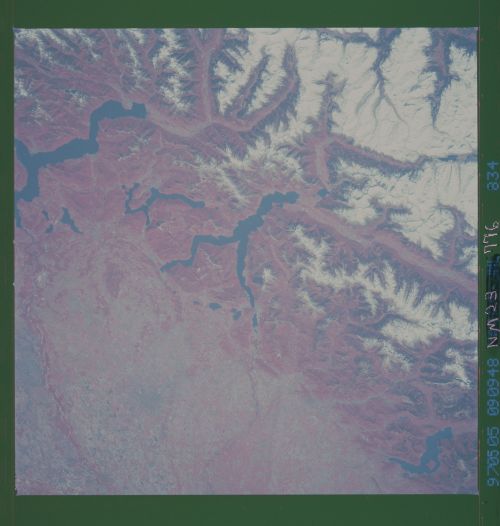
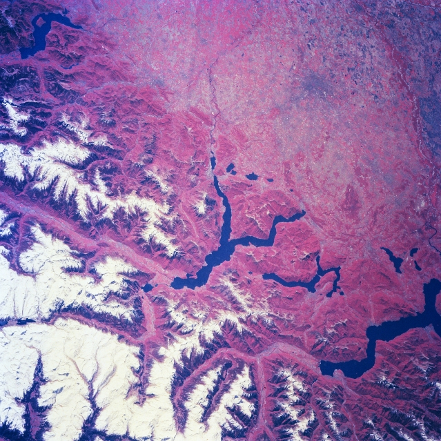
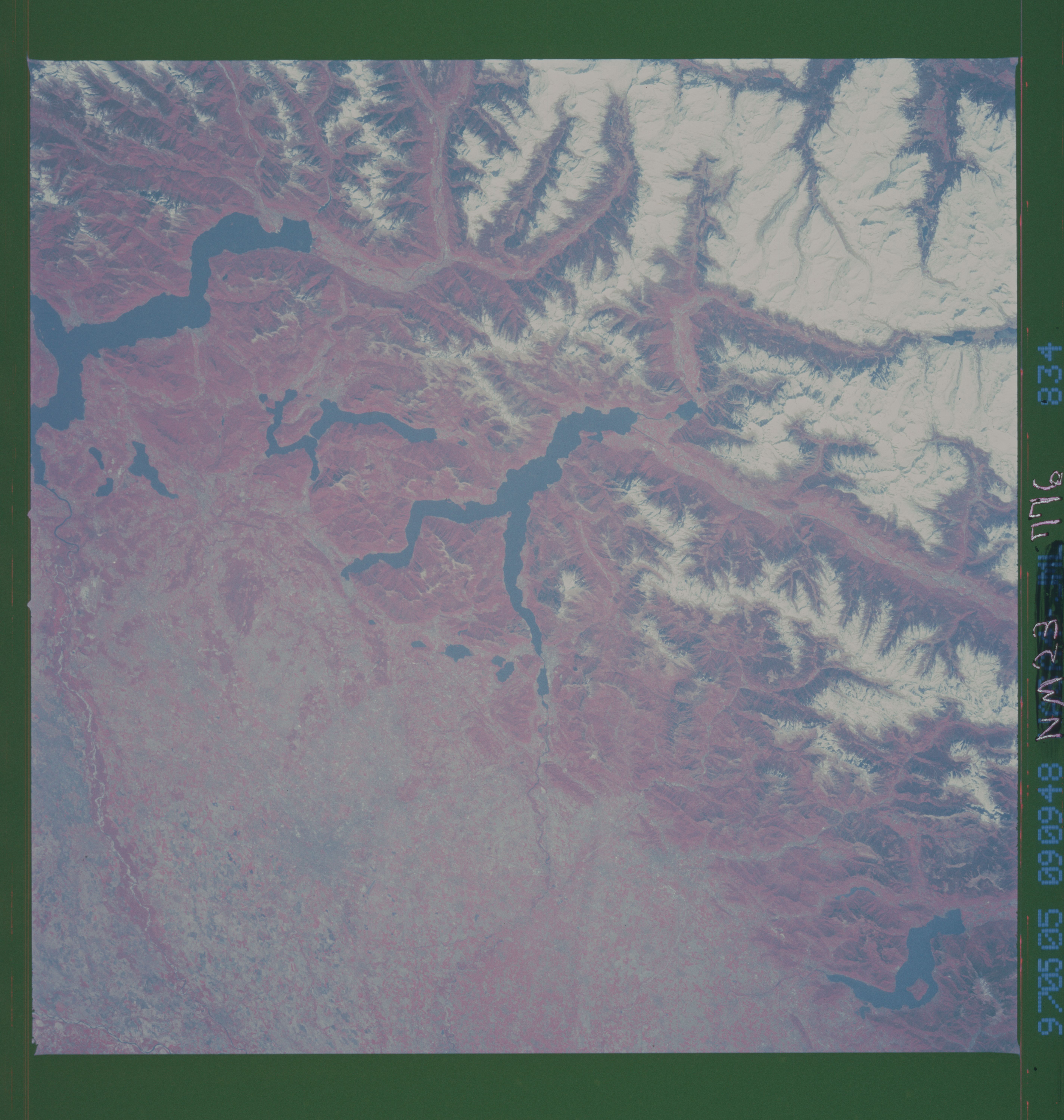
Image Caption: NM23-776-834 Italian Alps, Italy Winter/Spring 1997
Several elongated lakes (dark features) are identifiable in this southerly view of the Italian-Swiss border. The elongated lakes are the creation of alpine (or valley) glaciers that moved generally southward through this section of the Italian Alps over 12000 years ago. From west to east the four larger lakes are Maggiore (lower right corner), Lugana, Como, and d'Iseo (upper left corner). Smaller lakes (also dark features) are visible at the southern end of Lake Como (center of image) and Lake Maggiore. Subtle faults that are perpendicular to the southern end of the lakes can be traced east to west across the landscape at the base of the Italian Alps. Glaciated, U-shaped valleys are discernible north and northeast of the lakes. The color infrared helps to identify the densely vegetated mountain slopes where the forested land (green vegetation) is shown as concentrations of reddish patterns. The relatively flat plains of the highly industrialized and agriculturally productive Po River Valley (upper third of image) presents a dramatically different looking terrain than the snow covered mountainous region of northern Italy.
Several elongated lakes (dark features) are identifiable in this southerly view of the Italian-Swiss border. The elongated lakes are the creation of alpine (or valley) glaciers that moved generally southward through this section of the Italian Alps over 12000 years ago. From west to east the four larger lakes are Maggiore (lower right corner), Lugana, Como, and d'Iseo (upper left corner). Smaller lakes (also dark features) are visible at the southern end of Lake Como (center of image) and Lake Maggiore. Subtle faults that are perpendicular to the southern end of the lakes can be traced east to west across the landscape at the base of the Italian Alps. Glaciated, U-shaped valleys are discernible north and northeast of the lakes. The color infrared helps to identify the densely vegetated mountain slopes where the forested land (green vegetation) is shown as concentrations of reddish patterns. The relatively flat plains of the highly industrialized and agriculturally productive Po River Valley (upper third of image) presents a dramatically different looking terrain than the snow covered mountainous region of northern Italy.
