NM23-762-206

| NASA Photo ID | NM23-762-206 |
| Focal Length | 100mm |
| Date taken | 1997.05.02 |
| Time taken | 13:35:59 GMT |
Resolutions offered for this image:
4096 x 4096 pixels 640 x 640 pixels 5700 x 6000 pixels 500 x 526 pixels
4096 x 4096 pixels 640 x 640 pixels 5700 x 6000 pixels 500 x 526 pixels

Cloud masks available for this image:
Spacecraft nadir point: 49.9° N, 1.2° E
Photo center point: 50.5° N, 4.0° W
Photo center point by machine learning:
Photo center point: 50.5° N, 4.0° W
Photo center point by machine learning:
Nadir to Photo Center: West
Spacecraft Altitude: 210 nautical miles (389km)
Country or Geographic Name: | UK-ENGLAND |
Features: | PLYMOUTH |
| Features Found Using Machine Learning: | |
Cloud Cover Percentage: | 0 (no clouds present) |
Sun Elevation Angle: | 50° |
Sun Azimuth: | 221° |
Camera: | Hasselblad |
Focal Length: | 100mm |
Camera Tilt: | Low Oblique |
Format: | 5046: Kodak, natural color positive, Lumiere 100/5046, ASA 100, standard base |
Film Exposure: | Normal |
| Additional Information | |
| Width | Height | Annotated | Cropped | Purpose | Links |
|---|---|---|---|---|---|
| 4096 pixels | 4096 pixels | No | No | Earth From Space collection | Download Image |
| 640 pixels | 640 pixels | No | No | Earth From Space collection | Download Image |
| 5700 pixels | 6000 pixels | No | No | Download Image | |
| 500 pixels | 526 pixels | No | No | Download Image |
Download Packaged File
Download a Google Earth KML for this Image
View photo footprint information
Download a GeoTIFF for this photo
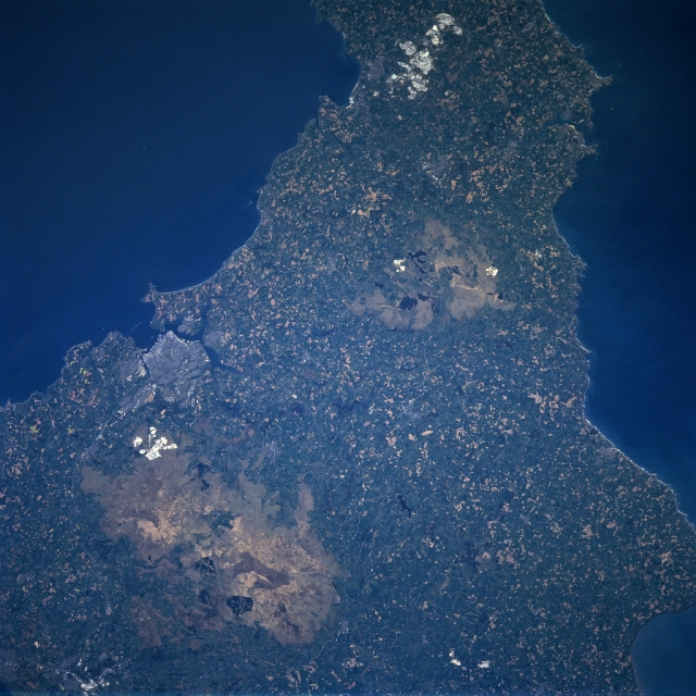
Image Caption: NM23-762-206 Dartmoor, Plymouth, Great Britain Winter/Spring 1997
A portion of the southwestern peninsula of Great Britain is visible in this southwest-looking view. In the lower left part of the image, the upland region called Dartmoor can be seen. Dartmoor covers an area of 365 sq. miles (945 sq. km). It is a wasteland of bare granite peaks called tors that rise 1600-2000 feet (488-610 meters) in altitude. During the middle Ages, Dartmoor was an important tin-mining region. Dating back to the 12th century, china clay and granite have been mined from this region. Near the center of the image, the Bodmin Moor, another smaller upland region can be seen. Southwest of Dartmoor near the left center of the image, the large port city of Plymouth can be identified. Located on Plymouth Sound on a peninsula between the estuaries of the Plym and Tamar Rivers, Plymouth is an important port and major naval base in Great Britain. The first English factory to make Chinese porcelain was established in Plymouth in 1768.
A portion of the southwestern peninsula of Great Britain is visible in this southwest-looking view. In the lower left part of the image, the upland region called Dartmoor can be seen. Dartmoor covers an area of 365 sq. miles (945 sq. km). It is a wasteland of bare granite peaks called tors that rise 1600-2000 feet (488-610 meters) in altitude. During the middle Ages, Dartmoor was an important tin-mining region. Dating back to the 12th century, china clay and granite have been mined from this region. Near the center of the image, the Bodmin Moor, another smaller upland region can be seen. Southwest of Dartmoor near the left center of the image, the large port city of Plymouth can be identified. Located on Plymouth Sound on a peninsula between the estuaries of the Plym and Tamar Rivers, Plymouth is an important port and major naval base in Great Britain. The first English factory to make Chinese porcelain was established in Plymouth in 1768.
