NM23-759-564
| NASA Photo ID | NM23-759-564 |
| Focal Length | 100mm |
| Date taken | 1997.05.01 |
| Time taken | 14:24:39 GMT |
Resolutions offered for this image:
4036 x 4036 pixels 639 x 639 pixels 5700 x 6000 pixels 500 x 526 pixels 500 x 503 pixels 480 x 480 pixels
4036 x 4036 pixels 639 x 639 pixels 5700 x 6000 pixels 500 x 526 pixels 500 x 503 pixels 480 x 480 pixels


Cloud masks available for this image:
Spacecraft nadir point: 49.7° N, 48.0° W
Photo center point: 47.5° N, 53.0° W
Photo center point by machine learning:
Photo center point: 47.5° N, 53.0° W
Photo center point by machine learning:
Nadir to Photo Center: West
Spacecraft Altitude: 208 nautical miles (385km)
Country or Geographic Name: | CANADA-N |
Features: | AVALON PENINSULA |
| Features Found Using Machine Learning: | |
Cloud Cover Percentage: | 0 (no clouds present) |
Sun Elevation Angle: | 55° |
Sun Azimuth: | 161° |
Camera: | Hasselblad |
Focal Length: | 100mm |
Camera Tilt: | Low Oblique |
Format: | 5046: Kodak, natural color positive, Lumiere 100/5046, ASA 100, standard base |
Film Exposure: | Normal |
| Additional Information | |
| Width | Height | Annotated | Cropped | Purpose | Links |
|---|---|---|---|---|---|
| 4036 pixels | 4036 pixels | No | No | Earth From Space collection | Download Image |
| 639 pixels | 639 pixels | No | No | Earth From Space collection | Download Image |
| 5700 pixels | 6000 pixels | No | No | Download Image | |
| 500 pixels | 526 pixels | No | No | Download Image | |
| 500 pixels | 503 pixels | No | No | Download Image | |
| 480 pixels | 480 pixels | Download Image |
Download Packaged File
Download a Google Earth KML for this Image
View photo footprint information
Download a GeoTIFF for this photo
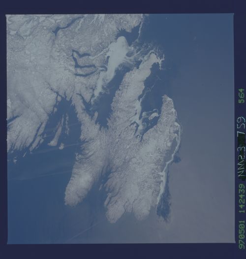
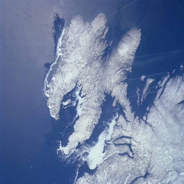
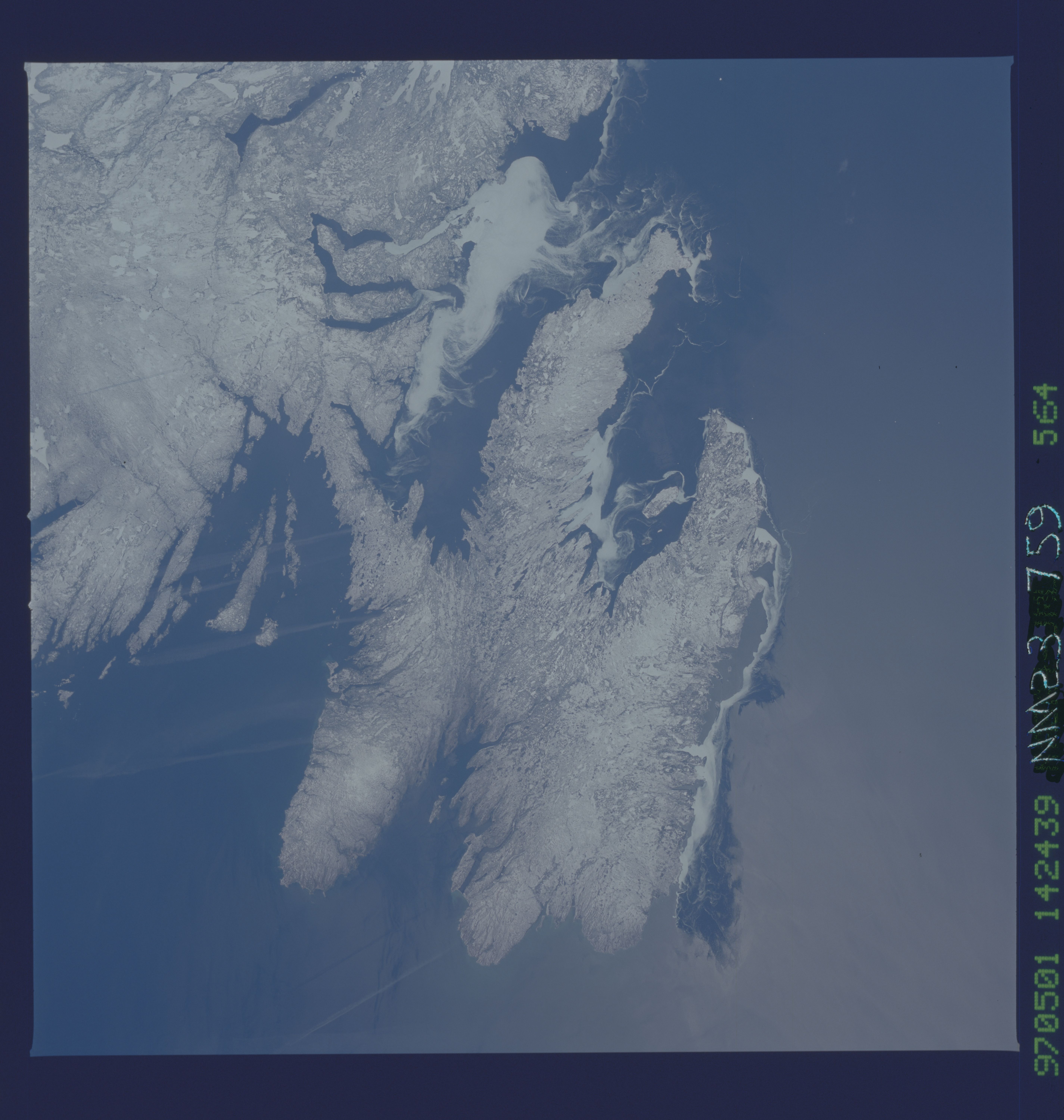
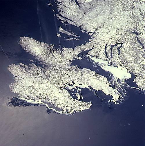
Image Caption: NM23-759-564 Avalon Peninsula, Newfoundland, Canada Winter 1997
The snow and ice covered coastline of southeastern Newfoundland, including the Avalon Peninsula, is visible in this western view of this island province of Canada. Sea ice is identified as the uniform-looking, whiter areas with a swirling pattern, especially evident in Trinity and Conception Bays along the north coast of the Avalon Peninsula. The two southern bays of Placenta and Saint Mary's do not show any sea ice; however, there is some ice visible along the east coast. Notice the snow and ice cover on the land looks different from the sea ice because snow accentuates some relief and contour details of the topography. The elongated, linear, light-colored "streaks" that are aligned in a general west-east orientation are aircraft contrails of jets flying from North America to Europe.
The snow and ice covered coastline of southeastern Newfoundland, including the Avalon Peninsula, is visible in this western view of this island province of Canada. Sea ice is identified as the uniform-looking, whiter areas with a swirling pattern, especially evident in Trinity and Conception Bays along the north coast of the Avalon Peninsula. The two southern bays of Placenta and Saint Mary's do not show any sea ice; however, there is some ice visible along the east coast. Notice the snow and ice cover on the land looks different from the sea ice because snow accentuates some relief and contour details of the topography. The elongated, linear, light-colored "streaks" that are aligned in a general west-east orientation are aircraft contrails of jets flying from North America to Europe.
