NM23-757-24
| NASA Photo ID | NM23-757-24 |
| Focal Length | 100mm |
| Date taken | 1997.05.01 |
| Time taken | 09:42:40 GMT |
Resolutions offered for this image:
4096 x 4080 pixels 640 x 637 pixels 5700 x 6000 pixels 500 x 526 pixels
4096 x 4080 pixels 640 x 637 pixels 5700 x 6000 pixels 500 x 526 pixels


Cloud masks available for this image:
Spacecraft nadir point: 40.6° N, 1.7° W
Photo center point: 36.5° N, 6.5° W
Photo center point by machine learning:
Photo center point: 36.5° N, 6.5° W
Photo center point by machine learning:
Nadir to Photo Center: Southwest
Spacecraft Altitude: 208 nautical miles (385km)
Country or Geographic Name: | SPAIN |
Features: | GUADALQUIVIR RIVER DELTA |
| Features Found Using Machine Learning: | |
Cloud Cover Percentage: | 0 (no clouds present) |
Sun Elevation Angle: | 50° |
Sun Azimuth: | 119° |
Camera: | Hasselblad |
Focal Length: | 100mm |
Camera Tilt: | Low Oblique |
Format: | 5046: Kodak, natural color positive, Lumiere 100/5046, ASA 100, standard base |
Film Exposure: | Normal |
| Additional Information | |
| Width | Height | Annotated | Cropped | Purpose | Links |
|---|---|---|---|---|---|
| 4096 pixels | 4080 pixels | No | No | Earth From Space collection | Download Image |
| 640 pixels | 637 pixels | No | No | Earth From Space collection | Download Image |
| 5700 pixels | 6000 pixels | No | No | Download Image | |
| 500 pixels | 526 pixels | No | No | Download Image |
Download Packaged File
Download a Google Earth KML for this Image
View photo footprint information
Download a GeoTIFF for this photo
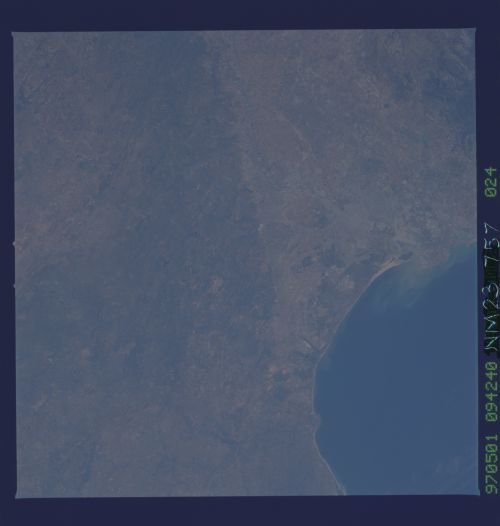
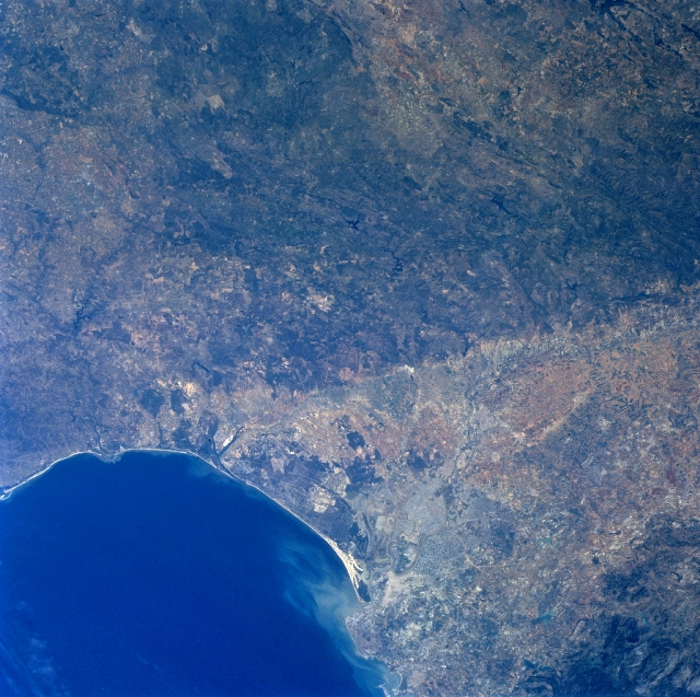
Image Caption: NM23-757-024 Guadaluivir River, Spain Winter/Spring 1997
Geologically this image can be divided into an old massif (darker looking landscape--center top) and an extensive, wedge-shaped depression, alluvial plain (lighter colored region) that is located south of the low mountains. Faulting has produced the distinct and fairly abrupt color change between the two physiographic features. Faulting within the Morena Mountains, however, is generally aligned in a northwest-southeast orientation. The Guadalquivir River is visible as it meanders and flows in a westerly direction along the southern edge of the Morena Mountains in southwest Spain. The location of Spain's third largest city, Seville (estimated population 800000), is barely visible along the east bank of the Guadalquivir River, after the river takes a more southerly course towards the Gulf of Cadiz. The river mouth is visible by the light-colored sediment plume that is being dispersed northwestward along the coast. A sizable wildlife sanctuary and the Donana National Park with it's extensive beach area and moving sand dunes, as well as a marshy landscape inland from the coast is located immediately north of the mouth of the Guadalquivir River. An intricate network of irrigation canals is also discernible between Seville and the mouth of the river.
Geologically this image can be divided into an old massif (darker looking landscape--center top) and an extensive, wedge-shaped depression, alluvial plain (lighter colored region) that is located south of the low mountains. Faulting has produced the distinct and fairly abrupt color change between the two physiographic features. Faulting within the Morena Mountains, however, is generally aligned in a northwest-southeast orientation. The Guadalquivir River is visible as it meanders and flows in a westerly direction along the southern edge of the Morena Mountains in southwest Spain. The location of Spain's third largest city, Seville (estimated population 800000), is barely visible along the east bank of the Guadalquivir River, after the river takes a more southerly course towards the Gulf of Cadiz. The river mouth is visible by the light-colored sediment plume that is being dispersed northwestward along the coast. A sizable wildlife sanctuary and the Donana National Park with it's extensive beach area and moving sand dunes, as well as a marshy landscape inland from the coast is located immediately north of the mouth of the Guadalquivir River. An intricate network of irrigation canals is also discernible between Seville and the mouth of the river.
