NM23-751-366
| NASA Photo ID | NM23-751-366 |
| Focal Length | 100mm |
| Date taken | 1997.04.29 |
| Time taken | 07:05:09 GMT |
Resolutions offered for this image:
4074 x 4068 pixels 639 x 639 pixels 5700 x 6000 pixels 500 x 526 pixels 522 x 513 pixels
4074 x 4068 pixels 639 x 639 pixels 5700 x 6000 pixels 500 x 526 pixels 522 x 513 pixels


Cloud masks available for this image:
Spacecraft nadir point: 51.7° N, 93.2° E
Photo center point: 50.0° N, 93.5° E
Photo center point by machine learning:
Photo center point: 50.0° N, 93.5° E
Photo center point by machine learning:
Nadir to Photo Center: South
Spacecraft Altitude: 209 nautical miles (387km)
Country or Geographic Name: | MONGOLIA |
Features: | UVS LAKE |
| Features Found Using Machine Learning: | |
Cloud Cover Percentage: | 5 (1-10)% |
Sun Elevation Angle: | 50° |
Sun Azimuth: | 211° |
Camera: | Hasselblad |
Focal Length: | 100mm |
Camera Tilt: | 26 degrees |
Format: | 5046: Kodak, natural color positive, Lumiere 100/5046, ASA 100, standard base |
Film Exposure: | Normal |
| Additional Information | |
| Width | Height | Annotated | Cropped | Purpose | Links |
|---|---|---|---|---|---|
| 4074 pixels | 4068 pixels | No | No | Earth From Space collection | Download Image |
| 639 pixels | 639 pixels | No | No | Earth From Space collection | Download Image |
| 5700 pixels | 6000 pixels | No | No | Download Image | |
| 500 pixels | 526 pixels | No | No | Download Image | |
| 522 pixels | 513 pixels | No | No | Download Image |
Download Packaged File
Download a Google Earth KML for this Image
View photo footprint information
Download a GeoTIFF for this photo
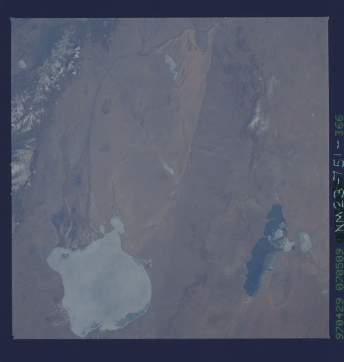
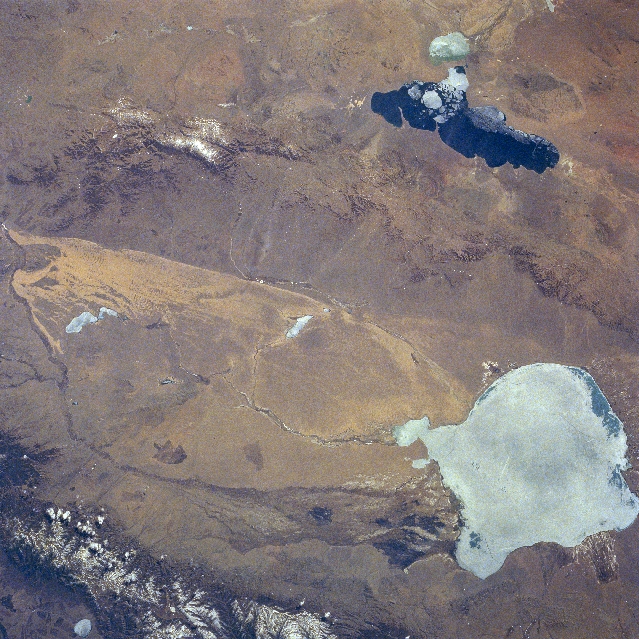
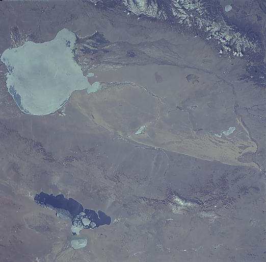
Image Caption: NM23-751-366 Uvs and Hyargas Lakes, Mongolia Winter/Spring 1997
Located in the lower right portion of the image, the ice-covered Uvs Lake, the largest salt lake in Mongolia, can be seen in this southeast-looking view. Covering an area of 1300 sq. miles (3370 sq. km), Uvs Lake has an average depth of only 20 feet (6 meters) with a maximum depth reaching 33 feet (10 meters). Situated in a basin, the lake is now part of a protected area by the International Geosphere-Biosphere Program for global change research. The range of ecological zones in this relatively small area of the Uvs Lake Basin is matched by few places in the world according to scientist working in the program. To the east (left) of the lake are the dunes of the Altan Els or "Golden Sands". Uvs Lake is fringed by marshes. The Turgen Mountains, with small glaciers and permanent snow, are visible to the north of the lake (bottom left of the image). The Tsagaan Shuvuut Range is discernible to the south of the Altan Els (upper left of the image). The partially ice-covered Hyargas or Khirgiz Lake can be seen in the upper right portion of the image.
Located in the lower right portion of the image, the ice-covered Uvs Lake, the largest salt lake in Mongolia, can be seen in this southeast-looking view. Covering an area of 1300 sq. miles (3370 sq. km), Uvs Lake has an average depth of only 20 feet (6 meters) with a maximum depth reaching 33 feet (10 meters). Situated in a basin, the lake is now part of a protected area by the International Geosphere-Biosphere Program for global change research. The range of ecological zones in this relatively small area of the Uvs Lake Basin is matched by few places in the world according to scientist working in the program. To the east (left) of the lake are the dunes of the Altan Els or "Golden Sands". Uvs Lake is fringed by marshes. The Turgen Mountains, with small glaciers and permanent snow, are visible to the north of the lake (bottom left of the image). The Tsagaan Shuvuut Range is discernible to the south of the Altan Els (upper left of the image). The partially ice-covered Hyargas or Khirgiz Lake can be seen in the upper right portion of the image.
