NM23-751-353

| NASA Photo ID | NM23-751-353 |
| Focal Length | 100mm |
| Date taken | 1997.04.29 |
| Time taken | 07:01:38 GMT |
Resolutions offered for this image:
4024 x 4024 pixels 640 x 640 pixels 5700 x 6000 pixels 500 x 526 pixels
4024 x 4024 pixels 640 x 640 pixels 5700 x 6000 pixels 500 x 526 pixels

Cloud masks available for this image:
Spacecraft nadir point: 48.9° N, 73.1° E
Photo center point: 45.5° N, 75.5° E
Photo center point by machine learning:
Photo center point: 45.5° N, 75.5° E
Photo center point by machine learning:
Nadir to Photo Center: Southeast
Spacecraft Altitude: 209 nautical miles (387km)
Country or Geographic Name: | KAZAKHSTAN |
Features: | ZHIDELI RIVER DELTA |
| Features Found Using Machine Learning: | |
Cloud Cover Percentage: | 0 (no clouds present) |
Sun Elevation Angle: | 56° |
Sun Azimuth: | 178° |
Camera: | Hasselblad |
Focal Length: | 100mm |
Camera Tilt: | 50 degrees |
Format: | 5046: Kodak, natural color positive, Lumiere 100/5046, ASA 100, standard base |
Film Exposure: | Normal |
| Additional Information | |
| Width | Height | Annotated | Cropped | Purpose | Links |
|---|---|---|---|---|---|
| 4024 pixels | 4024 pixels | No | No | Earth From Space collection | Download Image |
| 640 pixels | 640 pixels | No | No | Earth From Space collection | Download Image |
| 5700 pixels | 6000 pixels | No | No | Download Image | |
| 500 pixels | 526 pixels | No | No | Download Image |
Download Packaged File
Download a Google Earth KML for this Image
View photo footprint information
Download a GeoTIFF for this photo
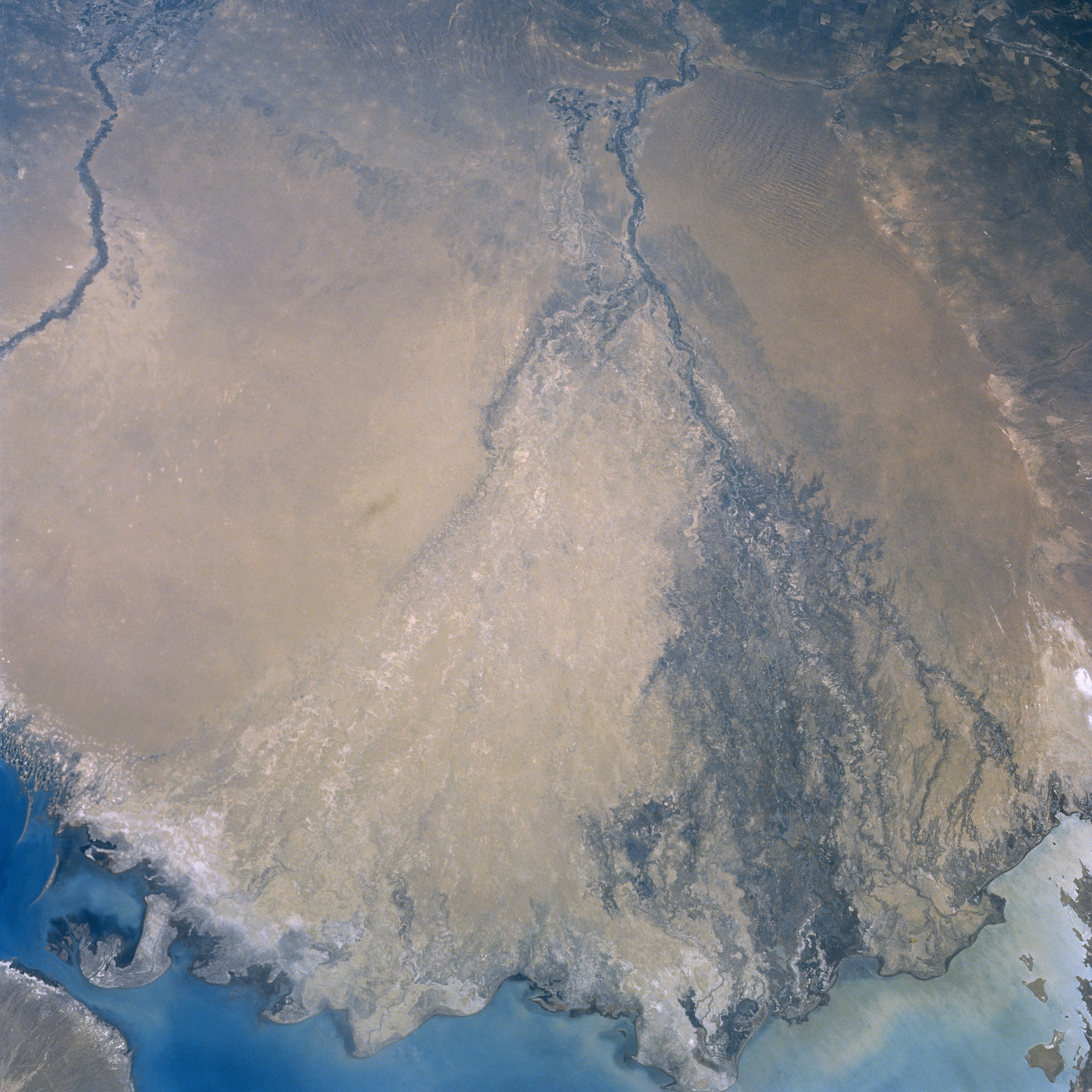
Image Caption: NM23-751-353 Ili River Delta, Kazakhstan Winter-Spring 1997
The waters of the Ili River emptying into Lake Balkhash (lower portion of image) can be seen in this south-southeast-looking view. Rising in the northern ranges of the Tien Shan, the Ili River is nearly 590 miles long (950 km). The river flows through the sandy Sarysesik-Atyran Desert (discernible on image) on its way to Lake Balkhash. During the rainy season, the river is navigable from the small city of Ili for about 280 miles (451 km). Toward the river's mouth, the area surrounding the Ili River is swampy. Irrigation is prevalent along its banks upstream from the river's mouth. A portion of the Karatal River is visible in the upper left portion of the image.
The waters of the Ili River emptying into Lake Balkhash (lower portion of image) can be seen in this south-southeast-looking view. Rising in the northern ranges of the Tien Shan, the Ili River is nearly 590 miles long (950 km). The river flows through the sandy Sarysesik-Atyran Desert (discernible on image) on its way to Lake Balkhash. During the rainy season, the river is navigable from the small city of Ili for about 280 miles (451 km). Toward the river's mouth, the area surrounding the Ili River is swampy. Irrigation is prevalent along its banks upstream from the river's mouth. A portion of the Karatal River is visible in the upper left portion of the image.
