NM23-743-36

| NASA Photo ID | NM23-743-36 |
| Focal Length | 250mm |
| Date taken | 1997.04.24 |
| Time taken | 11:16:06 GMT |
Resolutions offered for this image:
4072 x 4096 pixels 636 x 640 pixels 5700 x 6000 pixels 500 x 526 pixels
4072 x 4096 pixels 636 x 640 pixels 5700 x 6000 pixels 500 x 526 pixels

Cloud masks available for this image:
Spacecraft nadir point: 15.1° S, 38.2° W
Photo center point: 43.0° N, 0.5° E
Photo center point by machine learning:
Photo center point: 43.0° N, 0.5° E
Photo center point by machine learning:
Nadir to Photo Center: Northeast
Spacecraft Altitude: 209 nautical miles (387km)
Country or Geographic Name: | FRANCE |
Features: | PYRENEES |
| Features Found Using Machine Learning: | |
Cloud Cover Percentage: | 5 (1-10)% |
Sun Elevation Angle: | 34° |
Sun Azimuth: | 62° |
Camera: | Hasselblad |
Focal Length: | 250mm |
Camera Tilt: | Low Oblique |
Format: | 5046: Kodak, natural color positive, Lumiere 100/5046, ASA 100, standard base |
Film Exposure: | Normal |
| Additional Information | |
| Width | Height | Annotated | Cropped | Purpose | Links |
|---|---|---|---|---|---|
| 4072 pixels | 4096 pixels | No | No | Earth From Space collection | Download Image |
| 636 pixels | 640 pixels | No | No | Earth From Space collection | Download Image |
| 5700 pixels | 6000 pixels | No | No | Download Image | |
| 500 pixels | 526 pixels | No | No | Download Image |
Download Packaged File
Download a Google Earth KML for this Image
View photo footprint information
Download a GeoTIFF for this photo
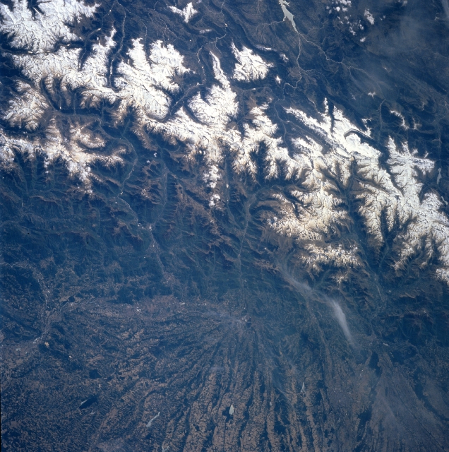
Image Caption: NM23-743-036 Pyrenees Mountains, Spain and France Winter/Spring 1997
The snow-capped Pyrenees Mountains form a natural barrier and border that separates France (bottom-north) and Spain (top-south). Aneto Peak, visible in this image slightly above the center of the picture, is the highest peak (11165 feet-3403 meters) of the Pyrenees. Numerous well-entrenched valleys can be identified on both sides of the border. Although the higher (in elevation) valleys were glaciated during the last ice age (Pleistocene period) and show U-shaped valleys below the jagged peaks, the valleys are not too extensive; and settlement is sparse throughout the mountainous region. An extremely large alluvial fan, marked by alternating dark lines and lighter-colored swaths, is visible radiating northward in France (bottom center). Many source areas (headwaters) of tributary streams are visible (light colored, winding, linear features) in northern Spain as they drain southward to eventually flow into the Ebro River. Streams on the French side of the border eventually empty into the Garonne River.
The snow-capped Pyrenees Mountains form a natural barrier and border that separates France (bottom-north) and Spain (top-south). Aneto Peak, visible in this image slightly above the center of the picture, is the highest peak (11165 feet-3403 meters) of the Pyrenees. Numerous well-entrenched valleys can be identified on both sides of the border. Although the higher (in elevation) valleys were glaciated during the last ice age (Pleistocene period) and show U-shaped valleys below the jagged peaks, the valleys are not too extensive; and settlement is sparse throughout the mountainous region. An extremely large alluvial fan, marked by alternating dark lines and lighter-colored swaths, is visible radiating northward in France (bottom center). Many source areas (headwaters) of tributary streams are visible (light colored, winding, linear features) in northern Spain as they drain southward to eventually flow into the Ebro River. Streams on the French side of the border eventually empty into the Garonne River.
