NM23-739-93

| NASA Photo ID | NM23-739-93 |
| Focal Length | 250mm |
| Date taken | 1997.04.18 |
| Time taken | 17:34:18 GMT |
Resolutions offered for this image:
4060 x 4060 pixels 639 x 639 pixels 5700 x 6000 pixels 500 x 526 pixels
4060 x 4060 pixels 639 x 639 pixels 5700 x 6000 pixels 500 x 526 pixels
Cloud masks available for this image:
Spacecraft nadir point: 19.5° N, 77.9° E
Photo center point: 23.5° N, 77.0° W
Photo center point by machine learning:
Photo center point: 23.5° N, 77.0° W
Photo center point by machine learning:
Nadir to Photo Center: West
Spacecraft Altitude: 211 nautical miles (391km)
Country or Geographic Name: | BAHAMAS |
Features: | TONGUE OF THE OCEAN |
| Features Found Using Machine Learning: | |
Cloud Cover Percentage: | 5 (1-10)% |
Sun Elevation Angle: | -55° |
Sun Azimuth: | 328° |
Camera: | Hasselblad |
Focal Length: | 250mm |
Camera Tilt: | Low Oblique |
Format: | 5046: Kodak, natural color positive, Lumiere 100/5046, ASA 100, standard base |
Film Exposure: | Normal |
| Additional Information | |
| Width | Height | Annotated | Cropped | Purpose | Links |
|---|---|---|---|---|---|
| 4060 pixels | 4060 pixels | No | No | Earth From Space collection | Download Image |
| 639 pixels | 639 pixels | No | No | Earth From Space collection | Download Image |
| 5700 pixels | 6000 pixels | No | No | Download Image | |
| 500 pixels | 526 pixels | No | No | Download Image |
Download Packaged File
Download a Google Earth KML for this Image
View photo footprint information
Download a GeoTIFF for this photo
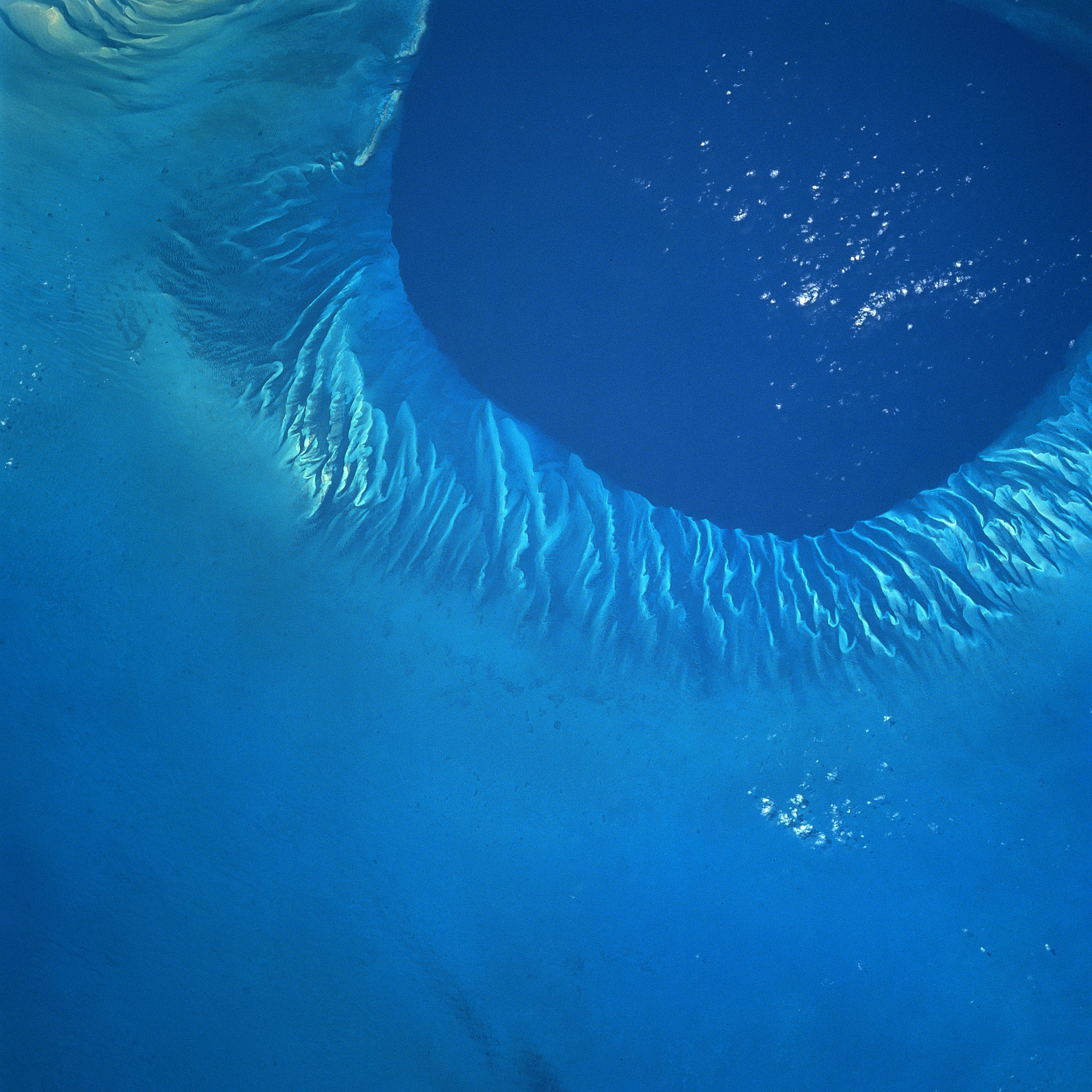
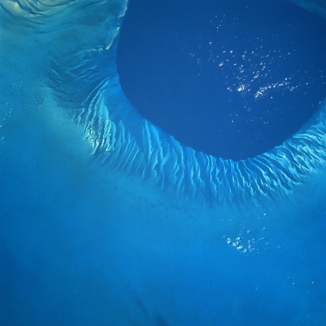
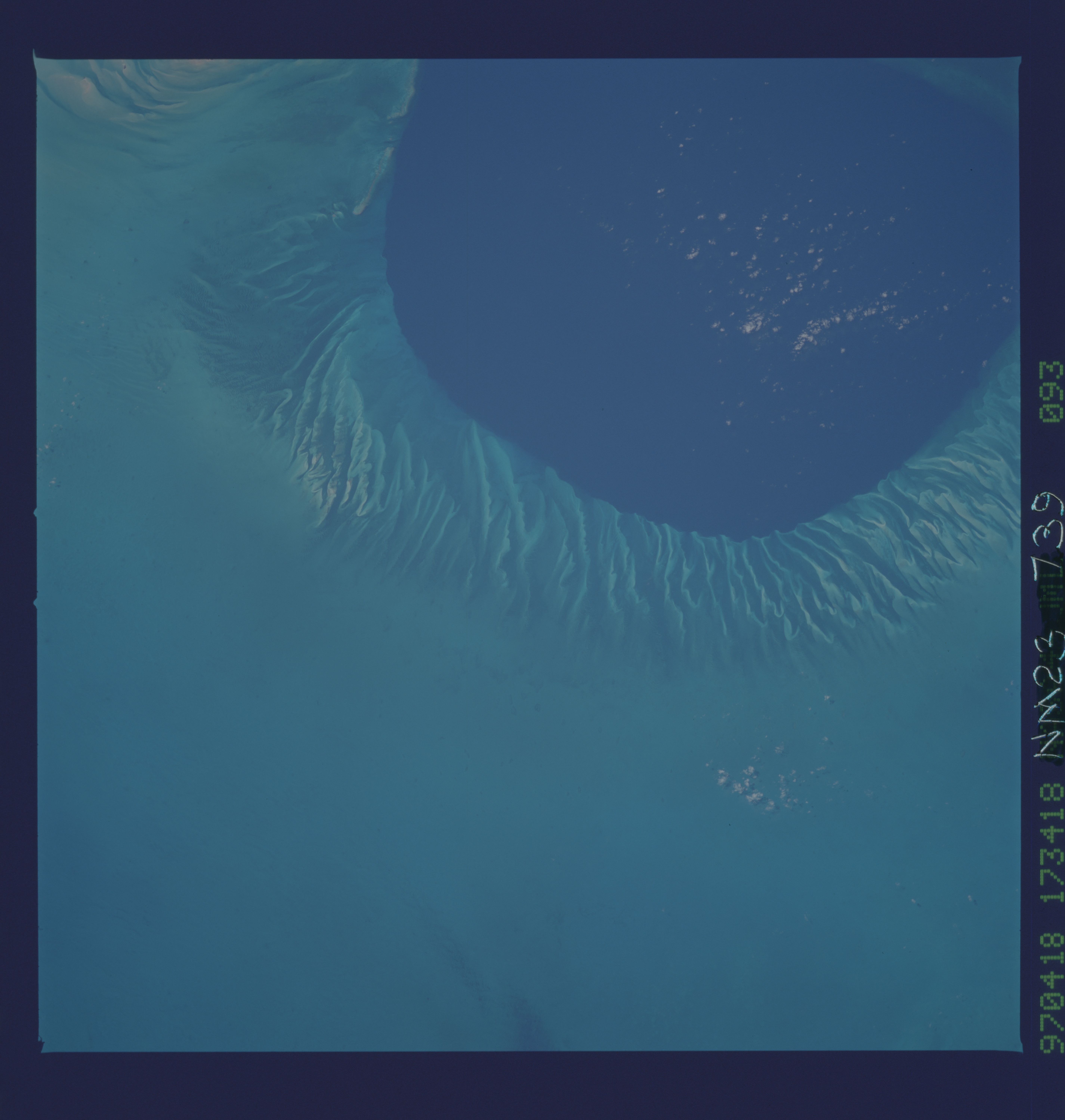
Image Caption: NM23-739-093 Tongue of the Ocean, Bahamas Winter/Spring 1997
The shallow Bahama shelf and the southern portion of the deep Tongue of the Ocean (darker water, upper right) can be seen in this northwest-looking view. The Tongue of the Ocean is one of two main branches that form the Great Bahama Canyon. The vertical rock walls of this submarine canyon rise 14060 feet (4285 meters) from the canyon floor to the surrounding seabed. The Grand Bahama Canyon has been traced for more than 140 miles (225 km) in length. The canyon has a width of 23 miles (37 km) at its deepest point and an average floor slope of about 300 feet per mile (60 meters per km). During the last Ice Age, nearly 12000 years ago, much of the Bahama Shelf was above sea level. Rainfall during that period formed erosional type gullies or small canyons as rainwater flowed off the shelf into the Tongue of the Ocean. As the climate warmed and the ice melted, sea levels rose to present levels covering the eroded gullies seen on this image.
The shallow Bahama shelf and the southern portion of the deep Tongue of the Ocean (darker water, upper right) can be seen in this northwest-looking view. The Tongue of the Ocean is one of two main branches that form the Great Bahama Canyon. The vertical rock walls of this submarine canyon rise 14060 feet (4285 meters) from the canyon floor to the surrounding seabed. The Grand Bahama Canyon has been traced for more than 140 miles (225 km) in length. The canyon has a width of 23 miles (37 km) at its deepest point and an average floor slope of about 300 feet per mile (60 meters per km). During the last Ice Age, nearly 12000 years ago, much of the Bahama Shelf was above sea level. Rainfall during that period formed erosional type gullies or small canyons as rainwater flowed off the shelf into the Tongue of the Ocean. As the climate warmed and the ice melted, sea levels rose to present levels covering the eroded gullies seen on this image.
