NM23-735-994
| NASA Photo ID | NM23-735-994 |
| Focal Length | 250mm |
| Date taken | 1997.04.18 |
| Time taken | 07:04:24 GMT |
Resolutions offered for this image:
4096 x 4096 pixels 640 x 640 pixels 5700 x 6000 pixels 500 x 526 pixels
4096 x 4096 pixels 640 x 640 pixels 5700 x 6000 pixels 500 x 526 pixels

Cloud masks available for this image:
Spacecraft nadir point: 29.0° S, 80.0° W
Photo center point: 54.5° N, 160.5° E
Photo center point by machine learning:
Photo center point: 54.5° N, 160.5° E
Photo center point by machine learning:
Nadir to Photo Center: Northwest
Spacecraft Altitude: 210 nautical miles (389km)
Country or Geographic Name: | RUSSIAN FEDERATION |
Features: | KAMCHATKA PEN., VOLCANOES |
| Features Found Using Machine Learning: | |
Cloud Cover Percentage: | 5 (1-10)% |
Sun Elevation Angle: | -60° |
Sun Azimuth: | 121° |
Camera: | Hasselblad |
Focal Length: | 250mm |
Camera Tilt: | Low Oblique |
Format: | 5046: Kodak, natural color positive, Lumiere 100/5046, ASA 100, standard base |
Film Exposure: | Normal |
| Additional Information | |
| Width | Height | Annotated | Cropped | Purpose | Links |
|---|---|---|---|---|---|
| 4096 pixels | 4096 pixels | No | No | Earth From Space collection | Download Image |
| 640 pixels | 640 pixels | No | No | Earth From Space collection | Download Image |
| 5700 pixels | 6000 pixels | No | No | Download Image | |
| 500 pixels | 526 pixels | No | No | Download Image |
Download Packaged File
Download a Google Earth KML for this Image
View photo footprint information
Download a GeoTIFF for this photo
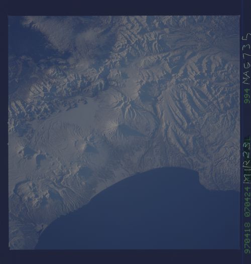
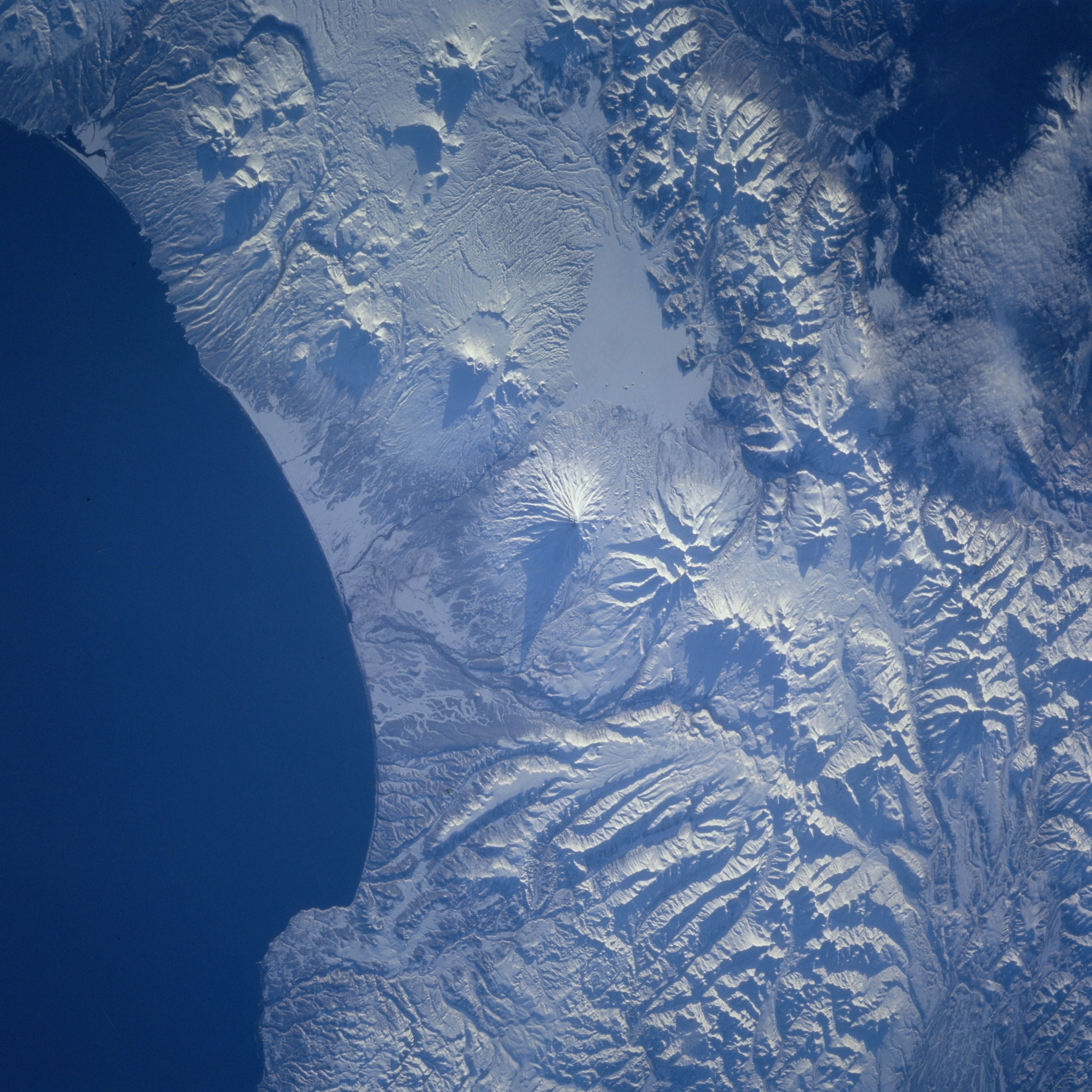
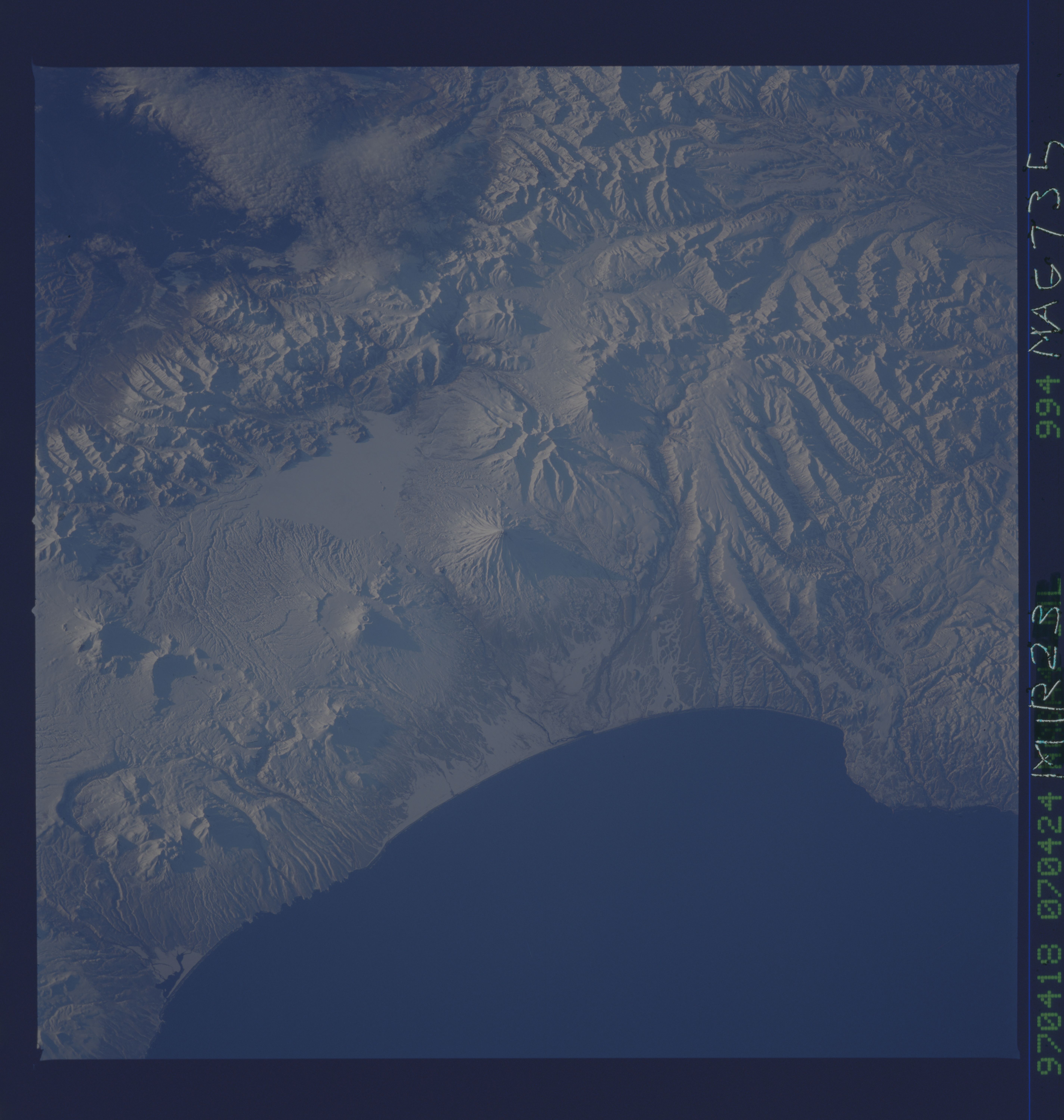
Image Caption: NM23-735-994 Kamchatka Volcanoes, Russia Winter/Spring 1997
The Kamchatka Peninsula of eastern Russia has an exceptionally high number of active volcanoes; at least 25 volcanoes still erupt from time to time. The subduction of the Pacific plate under the Eurasian plate has produced the formation of at least 125 volcanoes on the Kamchatka Peninsula. This particular snow-covered landscape is located along the southeast coast of the peninsula where the coastline borders the Gulf of Kronotskoye. Numerous volcanoes can be identified by the radial (drainage) patterns, generally circular shape, and their "shadowed" east facing slopes. The lengths of their shadows are directly related to the elevation of their respective crater rims or peaks. Kronotskaya Volcano, the tallest volcanic peak in the scene at 11570 feet (3528 meters) above sea level is visible casting a long, cone-shaped shadow in the center of the image. The pale-looking, uniform-textured feature west of Kronotskaya Volcano is frozen, snow-covered Lake Kronotskoye. A very narrow coastal plain with frozen, snow-covered vegetation in this part of the Kamchatka consists of arctic-alpine species and mountain tundra. The darker area (upper right corner) is part of the central valley where the Kamchatka River drains to the northeast. The rugged Vostochnyy Range of mountains, aligned in a northeast-southwest orientation separates the central valley from the line of volcanoes along the southeast coast.
The Kamchatka Peninsula of eastern Russia has an exceptionally high number of active volcanoes; at least 25 volcanoes still erupt from time to time. The subduction of the Pacific plate under the Eurasian plate has produced the formation of at least 125 volcanoes on the Kamchatka Peninsula. This particular snow-covered landscape is located along the southeast coast of the peninsula where the coastline borders the Gulf of Kronotskoye. Numerous volcanoes can be identified by the radial (drainage) patterns, generally circular shape, and their "shadowed" east facing slopes. The lengths of their shadows are directly related to the elevation of their respective crater rims or peaks. Kronotskaya Volcano, the tallest volcanic peak in the scene at 11570 feet (3528 meters) above sea level is visible casting a long, cone-shaped shadow in the center of the image. The pale-looking, uniform-textured feature west of Kronotskaya Volcano is frozen, snow-covered Lake Kronotskoye. A very narrow coastal plain with frozen, snow-covered vegetation in this part of the Kamchatka consists of arctic-alpine species and mountain tundra. The darker area (upper right corner) is part of the central valley where the Kamchatka River drains to the northeast. The rugged Vostochnyy Range of mountains, aligned in a northeast-southwest orientation separates the central valley from the line of volcanoes along the southeast coast.
