NM23-721-526

| NASA Photo ID | NM23-721-526 |
| Focal Length | 100mm |
| Date taken | 1997.04.03 |
| Time taken | GMT |
Resolutions offered for this image:
4096 x 4080 pixels 640 x 637 pixels 5700 x 6000 pixels 500 x 526 pixels 616 x 627 pixels 616 x 627 pixels
4096 x 4080 pixels 640 x 637 pixels 5700 x 6000 pixels 500 x 526 pixels 616 x 627 pixels 616 x 627 pixels

Cloud masks available for this image:
Spacecraft nadir point:
Photo center point: 33.5° S, 59.0° W
Photo center point by machine learning:
Photo center point: 33.5° S, 59.0° W
Photo center point by machine learning:
Nadir to Photo Center: Southwest
Spacecraft Altitude: nautical miles (0km)
Country or Geographic Name: | ARGENTINA |
Features: | RIO PARANA, BURN SCARS |
| Features Found Using Machine Learning: | |
Cloud Cover Percentage: | 5 (1-10)% |
Sun Elevation Angle: | ° |
Sun Azimuth: | ° |
Camera: | Hasselblad |
Focal Length: | 100mm |
Camera Tilt: | Low Oblique |
Format: | 5046: Kodak, natural color positive, Lumiere 100/5046, ASA 100, standard base |
Film Exposure: | Normal |
| Additional Information | |
| Width | Height | Annotated | Cropped | Purpose | Links |
|---|---|---|---|---|---|
| 4096 pixels | 4080 pixels | No | No | Earth From Space collection | Download Image |
| 640 pixels | 637 pixels | No | No | Earth From Space collection | Download Image |
| 5700 pixels | 6000 pixels | No | No | Download Image | |
| 500 pixels | 526 pixels | No | No | Download Image | |
| 616 pixels | 627 pixels | No | No | Download Image | |
| 616 pixels | 627 pixels | Download Image |
Download Packaged File
Download a Google Earth KML for this Image
View photo footprint information
Download a GeoTIFF for this photo
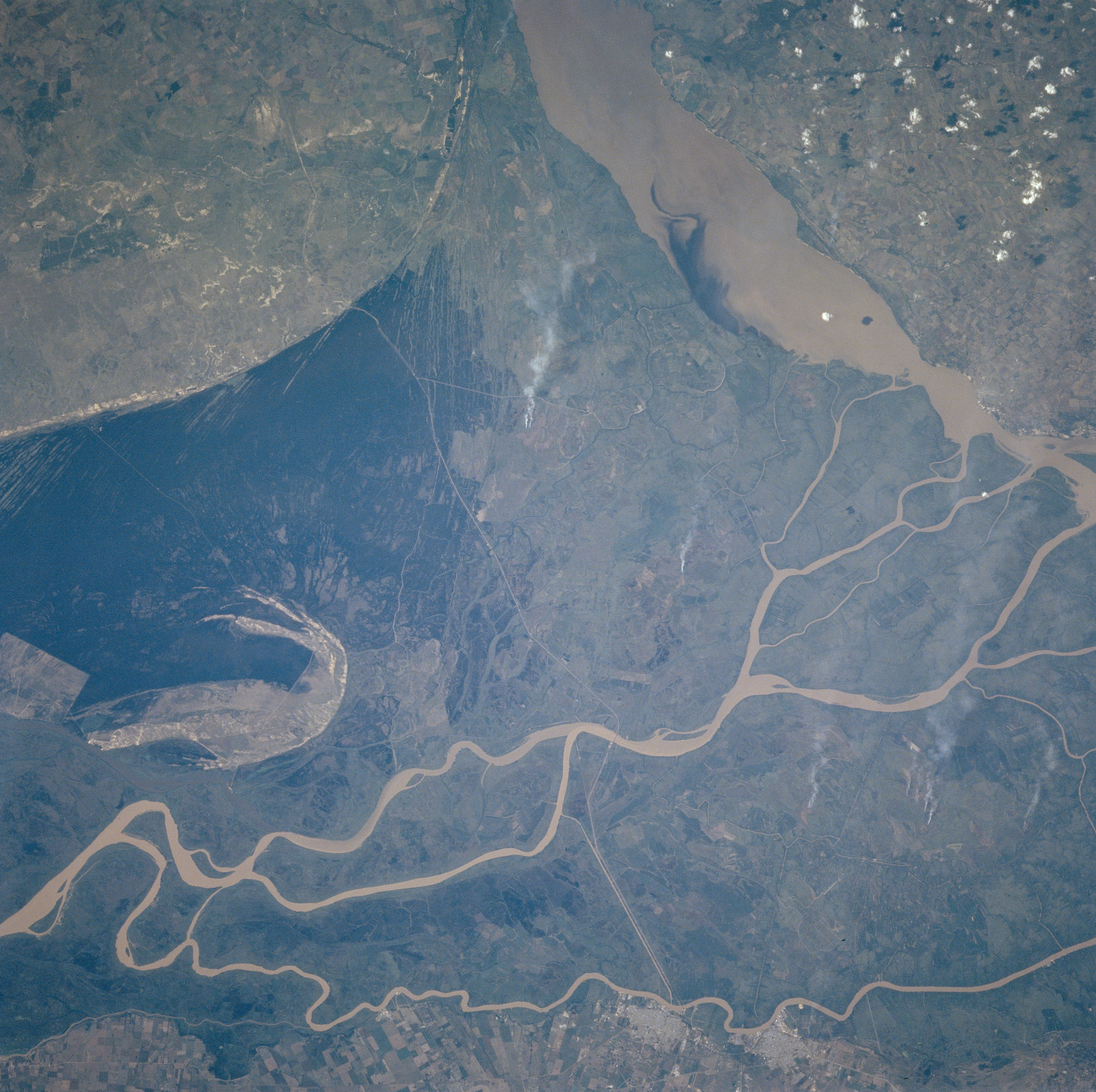
Image Caption: NM23-721-526 Rio Parana Delta, Argentina Winter/Spring 1997
The Rio Parana has created a very broad delta and floodplain at the mouth of the river along the western end of the Rio de la Plata. This delta and floodplain extends from the noticeably curving line near the top of the image to almost touching the bottom edge of the picture. Several distributary channels of the river are shown as light colored, narrow, linear features that wind in a generally eastward direction. The floodplain has been extensively modified. The floodplain is visible due to the differing vegetation patterns and the sharp edges within the delta. The very thin, light-colored line that extends north-south across the delta (middle of the picture) appears to be a highway. Several individual smoke plumes can be seen on the flat but slightly elevated land east of the highway on the delta. Two cities, Zarate and Campana (brighter features lower middle) can be identified along the southern channel (and southern boundary of the Rio Parana). The broader, muddy Rio Uruguay is visible in the upper right quadrant of the picture. The Uruguay River marks the border between Argentina and Uruguay.
The Rio Parana has created a very broad delta and floodplain at the mouth of the river along the western end of the Rio de la Plata. This delta and floodplain extends from the noticeably curving line near the top of the image to almost touching the bottom edge of the picture. Several distributary channels of the river are shown as light colored, narrow, linear features that wind in a generally eastward direction. The floodplain has been extensively modified. The floodplain is visible due to the differing vegetation patterns and the sharp edges within the delta. The very thin, light-colored line that extends north-south across the delta (middle of the picture) appears to be a highway. Several individual smoke plumes can be seen on the flat but slightly elevated land east of the highway on the delta. Two cities, Zarate and Campana (brighter features lower middle) can be identified along the southern channel (and southern boundary of the Rio Parana). The broader, muddy Rio Uruguay is visible in the upper right quadrant of the picture. The Uruguay River marks the border between Argentina and Uruguay.
