NM23-721-514

| NASA Photo ID | NM23-721-514 |
| Focal Length | 100mm |
| Date taken | 1997.04.03 |
| Time taken | GMT |
Resolutions offered for this image:
4096 x 4064 pixels 640 x 635 pixels 5700 x 6000 pixels 500 x 526 pixels
4096 x 4064 pixels 640 x 635 pixels 5700 x 6000 pixels 500 x 526 pixels


Cloud masks available for this image:
Spacecraft nadir point:
Photo center point: 39.0° S, 68.0° W
Photo center point by machine learning:
Photo center point: 39.0° S, 68.0° W
Photo center point by machine learning:
Nadir to Photo Center: Southwest
Spacecraft Altitude: nautical miles (0km)
Country or Geographic Name: | ARGENTINA |
Features: | LAKE PELLEGRINI, AGR. |
| Features Found Using Machine Learning: | |
Cloud Cover Percentage: | 0 (no clouds present) |
Sun Elevation Angle: | ° |
Sun Azimuth: | ° |
Camera: | Hasselblad |
Focal Length: | 100mm |
Camera Tilt: | Low Oblique |
Format: | 5046: Kodak, natural color positive, Lumiere 100/5046, ASA 100, standard base |
Film Exposure: | Normal |
| Additional Information | |
| Width | Height | Annotated | Cropped | Purpose | Links |
|---|---|---|---|---|---|
| 4096 pixels | 4064 pixels | No | No | Earth From Space collection | Download Image |
| 640 pixels | 635 pixels | No | No | Earth From Space collection | Download Image |
| 5700 pixels | 6000 pixels | No | No | Download Image | |
| 500 pixels | 526 pixels | No | No | Download Image |
Download Packaged File
Download a Google Earth KML for this Image
View photo footprint information
Download a GeoTIFF for this photo
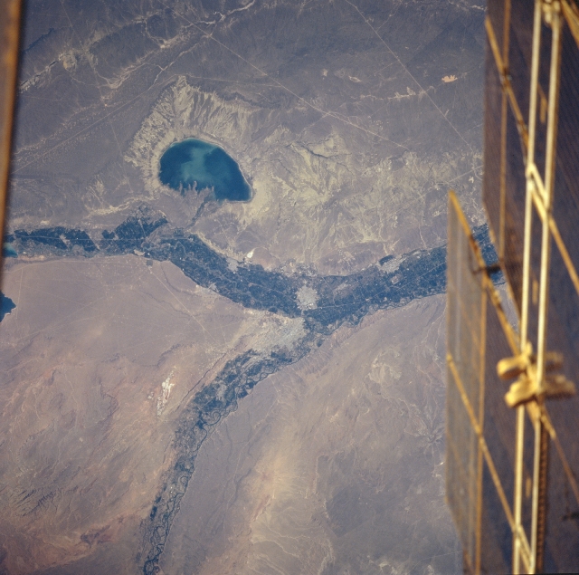
Image Caption: NM23-721-514 Lake Pellegrini, Rio Negro, Argentina Winter/Spring 1997
This near-vertical looking view shows the confluence of the Neuquen (left center) and the Limay (bottom left) Rivers that forms the Rio Negro (just to the right of the center of the image). The confluence of the two rivers occurs near the small city of Cipolletti. Numerous small towns dot the floodplain of the river. Lake Pellegrini is visible to the east of the Neuquen River. The lake has no inlet but does have an outlet to the Neuquen River. The semi-arid, windswept brown-colored plateau of Patagonia is visible throughout the scene outside of the river floodplains and lakes. A portion of the space station MIR is visible along the right edge of the image.
This near-vertical looking view shows the confluence of the Neuquen (left center) and the Limay (bottom left) Rivers that forms the Rio Negro (just to the right of the center of the image). The confluence of the two rivers occurs near the small city of Cipolletti. Numerous small towns dot the floodplain of the river. Lake Pellegrini is visible to the east of the Neuquen River. The lake has no inlet but does have an outlet to the Neuquen River. The semi-arid, windswept brown-colored plateau of Patagonia is visible throughout the scene outside of the river floodplains and lakes. A portion of the space station MIR is visible along the right edge of the image.
