NM23-719-453
| NASA Photo ID | NM23-719-453 |
| Focal Length | 100mm |
| Date taken | 1997.03.28 |
| Time taken | GMT |
Resolutions offered for this image:
4096 x 4048 pixels 640 x 632 pixels 5700 x 6000 pixels 500 x 526 pixels
4096 x 4048 pixels 640 x 632 pixels 5700 x 6000 pixels 500 x 526 pixels


Cloud masks available for this image:
Spacecraft nadir point:
Photo center point: 35.0° S, 56.0° W
Photo center point by machine learning:
Photo center point: 35.0° S, 56.0° W
Photo center point by machine learning:
Nadir to Photo Center: Southeast
Spacecraft Altitude: nautical miles (0km)
Country or Geographic Name: | URUGUAY |
Features: | MONTEVIDEO |
| Features Found Using Machine Learning: | |
Cloud Cover Percentage: | 0 (no clouds present) |
Sun Elevation Angle: | ° |
Sun Azimuth: | ° |
Camera: | Hasselblad |
Focal Length: | 100mm |
Camera Tilt: | Low Oblique |
Format: | 5046: Kodak, natural color positive, Lumiere 100/5046, ASA 100, standard base |
Film Exposure: | Normal |
| Additional Information | |
| Width | Height | Annotated | Cropped | Purpose | Links |
|---|---|---|---|---|---|
| 4096 pixels | 4048 pixels | No | No | Earth From Space collection | Download Image |
| 640 pixels | 632 pixels | No | No | Earth From Space collection | Download Image |
| 5700 pixels | 6000 pixels | No | No | Download Image | |
| 500 pixels | 526 pixels | No | No | Download Image |
Download Packaged File
Download a Google Earth KML for this Image
View photo footprint information
Download a GeoTIFF for this photo
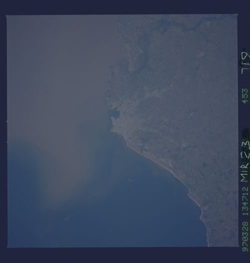
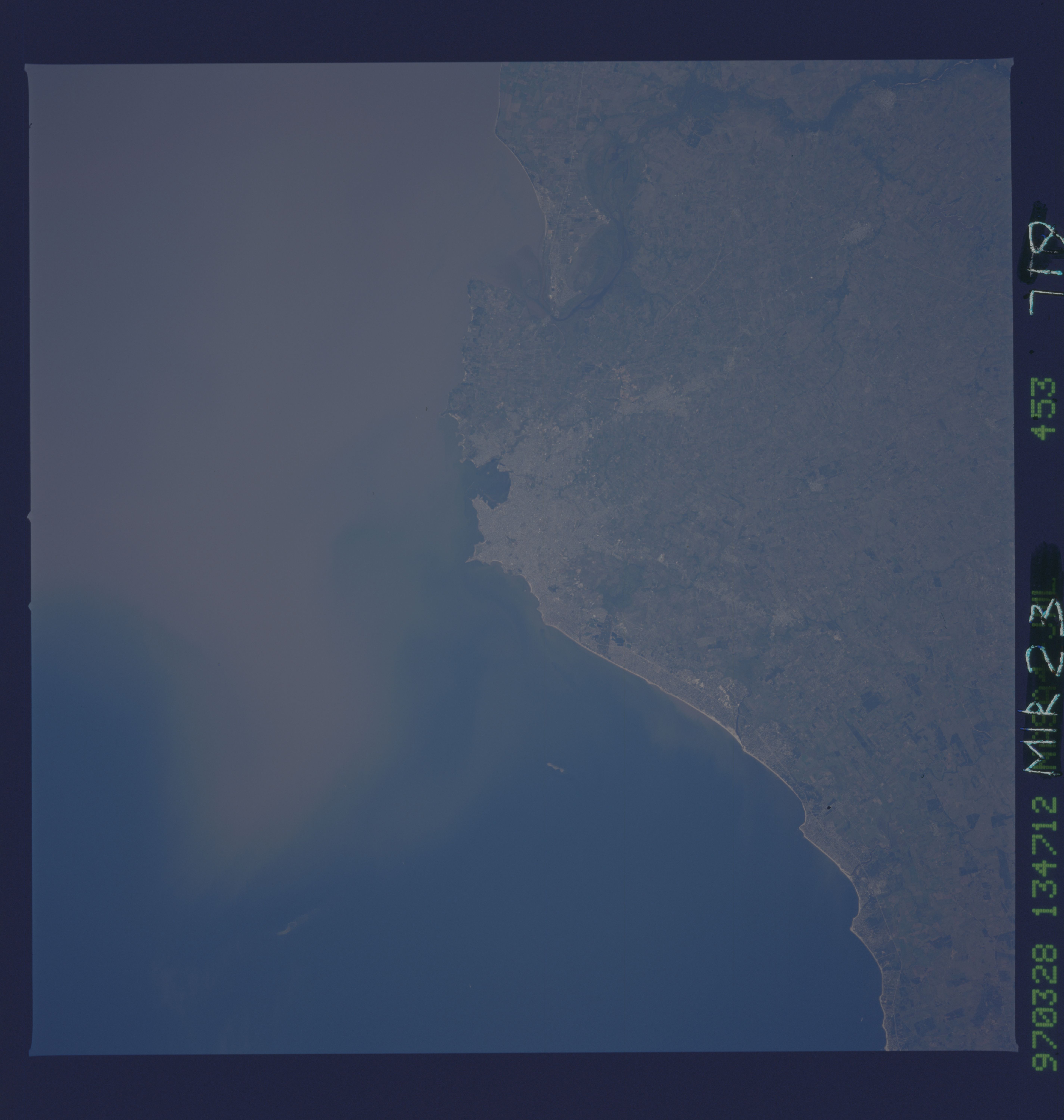
Image Caption: NM23-719-453 Montevideo, Uruguay Winter/Spring 1997
The capital city of Uruguay, Montevideo can be seen in this south-southwest-looking view. Montevideo is on the north shore of the Rio de la Plata and has well-protected harbor and facilities. Much of the South Atlantic fishing fleet is based in Montevideo. The city is the hub of the Uruguayan rail and highway systems that connect with the Argentine and Brazilian networks, as well as for air and sea routes. Montevideo is the commercial, industrial, financial, medical, and cultural center of the country. Over half of the population of Montevideo lives in the metropolitan area. Major industries include slaughtering and meatpacking, flour milling, clothing and textile manufacturing, oil refining, petrochemical and cement production, and power generation. Montevideo is famous for beaches and seaside resorts that stretch eastward from the city to Punta del Este on the Atlantic Ocean. Sediment-laden waters of the Rio de la Plata are visible at upper right and center. A dramatic event in the city's modern history occurred in December 1939 during World War II when the German battleship Graf Spee, already heavily damaged by British warships, was scuttled outside the Montevideo harbor.
The capital city of Uruguay, Montevideo can be seen in this south-southwest-looking view. Montevideo is on the north shore of the Rio de la Plata and has well-protected harbor and facilities. Much of the South Atlantic fishing fleet is based in Montevideo. The city is the hub of the Uruguayan rail and highway systems that connect with the Argentine and Brazilian networks, as well as for air and sea routes. Montevideo is the commercial, industrial, financial, medical, and cultural center of the country. Over half of the population of Montevideo lives in the metropolitan area. Major industries include slaughtering and meatpacking, flour milling, clothing and textile manufacturing, oil refining, petrochemical and cement production, and power generation. Montevideo is famous for beaches and seaside resorts that stretch eastward from the city to Punta del Este on the Atlantic Ocean. Sediment-laden waters of the Rio de la Plata are visible at upper right and center. A dramatic event in the city's modern history occurred in December 1939 during World War II when the German battleship Graf Spee, already heavily damaged by British warships, was scuttled outside the Montevideo harbor.
