NM22-727-19
| NASA Photo ID | NM22-727-19 |
| Focal Length | 250mm |
| Date taken | 1996.10.28 |
| Time taken | GMT |


Cloud masks available for this image:
Spacecraft nadir point:
Photo center point: 19.0° N, 122.0° W
Photo center point by machine learning:
Photo center point: 19.0° N, 122.0° W
Photo center point by machine learning:
Nadir to Photo Center: Southwest
Spacecraft Altitude: nautical miles (0km)
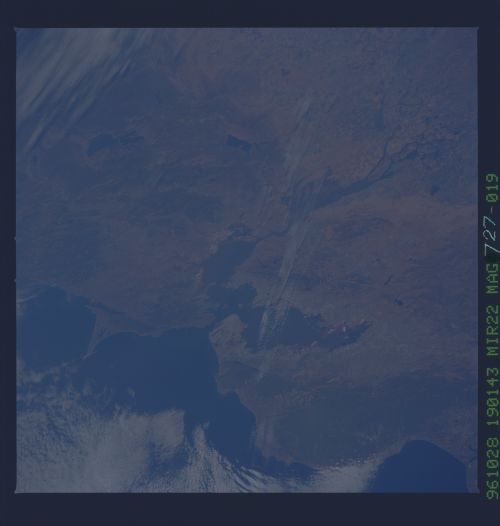
Country or Geographic Name: | USA-CALIFORNIA |
Features: | SAN FRANCISCO BAY AREA |
| Features Found Using Machine Learning: | |
Cloud Cover Percentage: | 15 (11-25)% |
Sun Elevation Angle: | ° |
Sun Azimuth: | ° |
Camera: | Hasselblad |
Focal Length: | 250mm |
Camera Tilt: | Low Oblique |
Format: | 5046: Kodak, natural color positive, Lumiere 100/5046, ASA 100, standard base |
Film Exposure: | Normal |
| Additional Information | |
| Width | Height | Annotated | Cropped | Purpose | Links |
|---|---|---|---|---|---|
| 5700 pixels | 6000 pixels | No | No | Download Image | |
| 500 pixels | 526 pixels | No | No | Download Image | |
| 640 pixels | 640 pixels | Yes | No | Download Image |
Download Packaged File
Download a Google Earth KML for this Image
View photo footprint information
Download a GeoTIFF for this photo
Image Caption: The wide view from the Mir captures the regional structures around San Francisco Bay, including the city of San Francisco, Tomales Bay and Pt. Reyes. The San Andreas fault passes seaward of the Golden Gate and continues northward to create Tomales Bay.
