NM21-774-82
| NASA Photo ID | NM21-774-82 |
| Focal Length | 50mm |
| Date taken | 1996.07.21 |
| Time taken | 16:45:38 GMT |
Resolutions offered for this image:
3904 x 3904 pixels 639 x 639 pixels 5700 x 6000 pixels 500 x 526 pixels
3904 x 3904 pixels 639 x 639 pixels 5700 x 6000 pixels 500 x 526 pixels


Cloud masks available for this image:
Spacecraft nadir point: 43.9° N, 109.0° W
Photo center point: 44.5° N, 109.5° W
Photo center point by machine learning:
Photo center point: 44.5° N, 109.5° W
Photo center point by machine learning:
Nadir to Photo Center: Northwest
Spacecraft Altitude: 207 nautical miles (383km)
Country or Geographic Name: | USA-WYOMING |
Features: | YELLOWSTONE L., DRAINAGE |
| Features Found Using Machine Learning: | |
Cloud Cover Percentage: | 5 (1-10)% |
Sun Elevation Angle: | 50° |
Sun Azimuth: | 113° |
Camera: | Hasselblad |
Focal Length: | 50mm |
Camera Tilt: | 13 degrees |
Format: | 5046: Kodak, natural color positive, Lumiere 100/5046, ASA 100, standard base |
Film Exposure: | Normal |
| Additional Information | |
| Width | Height | Annotated | Cropped | Purpose | Links |
|---|---|---|---|---|---|
| 3904 pixels | 3904 pixels | No | No | Earth From Space collection | Download Image |
| 639 pixels | 639 pixels | No | No | Earth From Space collection | Download Image |
| 5700 pixels | 6000 pixels | No | No | Download Image | |
| 500 pixels | 526 pixels | No | No | Download Image |
Download Packaged File
Download a Google Earth KML for this Image
View photo footprint information
Download a GeoTIFF for this photo
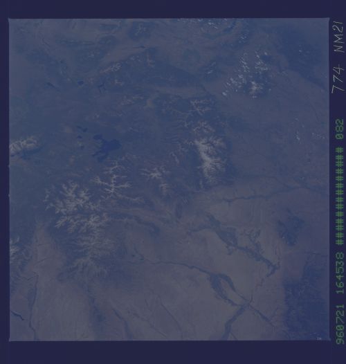
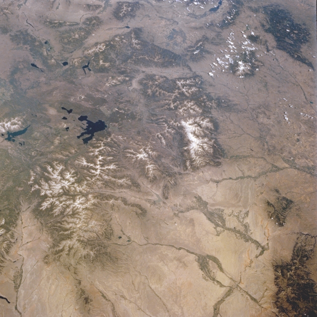
Image Caption: NM21-774-082 Yellowstone National Park, Wyoming, U.S.A. Fall and Winter 1995
Featured in this panoramic northwest-looking photograph is the oldest national park in the world, Yellowstone National Park, which encompasses approximately 3500 square miles (9000 square kilometers) of high plateau country in northwest Wyoming. With approximately 300 geysers and 10 000 hot springs and steam vents, the park boasts the world's largest, most varied collection of geothermal phenomena. Viewing clockwise from the Teton Range and Jackson Lake, which lie south-southwest of Yellowstone Lake, are the Tobacco Root Mountains of Montana (top center); the Madison and Gallatin Ranges of southern Montana; the Little Belt Mountains of Montana (top right) with the Absaroka Mountains of Montana and northern Wyoming to their south; the Pryor Mountains of southern Montana; the northern Bighorn Mountains of north-central Wyoming (bottom right); and the lighter Bighorn Basin of Wyoming between the Bighorn Mountains and Yellowstone (bottom).
Large fire scars from the extensive forest fires in 1988 are still visible as lighter green areas, especially along the western boundary of the park (line extending from upper left to top center). The fire scars are highlighted by snow in the winter scene NM22-727-24.
