NM21-771-7
| NASA Photo ID | NM21-771-7 |
| Focal Length | 100mm |
| Date taken | 1996.07.09 |
| Time taken | 09:43:52 GMT |

Cloud masks available for this image:
Spacecraft nadir point: 51.7° N, 26.9° E
Photo center point: 51.0° N, 30.5° E
Photo center point by machine learning:
Photo center point: 51.0° N, 30.5° E
Photo center point by machine learning:
Nadir to Photo Center: East
Spacecraft Altitude: 207 nautical miles (383km)
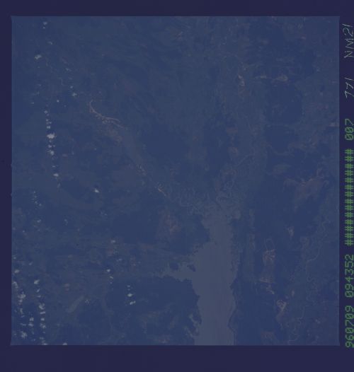
Country or Geographic Name: | UKRAINE |
Features: | KIYEVSKOYE R., CHERNOBYL |
| Features Found Using Machine Learning: | |
Cloud Cover Percentage: | 5 (1-10)% |
Sun Elevation Angle: | 60° |
Sun Azimuth: | 164° |
Camera: | Hasselblad |
Focal Length: | 100mm |
Camera Tilt: | 47 degrees |
Format: | 5046: Kodak, natural color positive, Lumiere 100/5046, ASA 100, standard base |
Film Exposure: | Normal |
| Additional Information | |
| Width | Height | Annotated | Cropped | Purpose | Links |
|---|---|---|---|---|---|
| 5700 pixels | 6000 pixels | No | No | Download Image | |
| 500 pixels | 526 pixels | No | No | Download Image |
Download Packaged File
Download a Google Earth KML for this Image
View photo footprint information
Download a GeoTIFF for this photo
Image Caption: The Chernobyl power plant sits on the Pripyat River just north of Kiev. The large lake in the center is a reservoir on the Dniepr; Kiev is off the field of view at the bottom. The bright region toward the upper left is part of the Chernobyl power plant infrastructure constructed after the 1986 accident. The cooling pond can also be seen. Russian and Ukrainian scientists are monitoring the growth of the vegetation surrounding the power plant and contrasting forest health with data from other parts of the country not proximal to the high doses of radiation.
