NM21-766-69
| NASA Photo ID | NM21-766-69 |
| Focal Length | 250mm |
| Date taken | 1996.07.05 |
| Time taken | GMT |
Resolutions offered for this image:
3880 x 3874 pixels 639 x 639 pixels 5700 x 6000 pixels 500 x 526 pixels
3880 x 3874 pixels 639 x 639 pixels 5700 x 6000 pixels 500 x 526 pixels


Cloud masks available for this image:
Spacecraft nadir point:
Photo center point: 40.5° N, 73.5° W
Photo center point by machine learning:
Photo center point: 40.5° N, 73.5° W
Photo center point by machine learning:
Nadir to Photo Center: North
Spacecraft Altitude: nautical miles (0km)
Country or Geographic Name: | USA-NEW YORK |
Features: | LONG ISLAND, STREETS, COAST |
| Features Found Using Machine Learning: | |
Cloud Cover Percentage: | 0 (no clouds present) |
Sun Elevation Angle: | ° |
Sun Azimuth: | ° |
Camera: | Hasselblad |
Focal Length: | 250mm |
Camera Tilt: | Low Oblique |
Format: | 5046: Kodak, natural color positive, Lumiere 100/5046, ASA 100, standard base |
Film Exposure: | Normal |
| Additional Information | |
| Width | Height | Annotated | Cropped | Purpose | Links |
|---|---|---|---|---|---|
| 3880 pixels | 3874 pixels | No | No | Earth From Space collection | Download Image |
| 639 pixels | 639 pixels | No | No | Earth From Space collection | Download Image |
| 5700 pixels | 6000 pixels | No | No | Download Image | |
| 500 pixels | 526 pixels | No | No | Download Image |
Download Packaged File
Download a Google Earth KML for this Image
View photo footprint information
Download a GeoTIFF for this photo
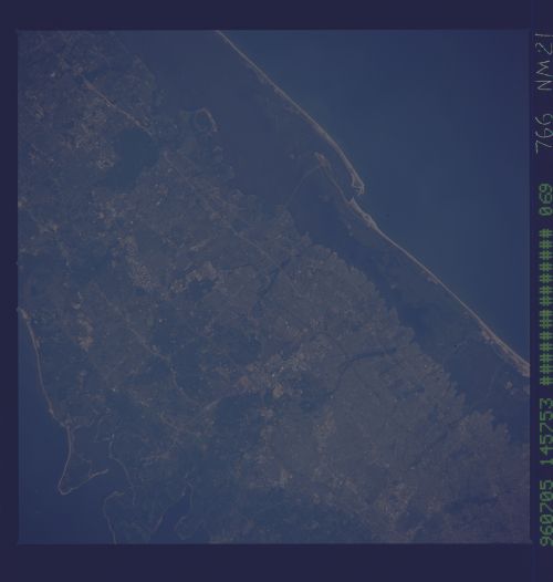
Image Caption: NM21-766-069 Long Island, New York Spring-Summer 1996
The urban sprawl of central Long Island can be seen in this northwest-looking view. Long Island is made up of glacial moraines and outwash plains. Northern Long Island (upper right) is marked with wooded low hills and low cliffs, and is deeply indented with bays. Southern Long Island has long beaches, backed by dunes and shallow lagoons. Near the upper right of the image, Huntington Bay and Eatons Neck point are discernible. Near the bottom center of the image, the western portion of the Fire Island national Seashore backed by Great South Bay is visible. Extensive beaches backed by South Oyster Bay can be seen near the center left of the image. Numerous highways are discernible traversing the image from west to east through many small cities and urban areas. The wooded area visible near the bottom right of the image is Connetquot River State Park.
The urban sprawl of central Long Island can be seen in this northwest-looking view. Long Island is made up of glacial moraines and outwash plains. Northern Long Island (upper right) is marked with wooded low hills and low cliffs, and is deeply indented with bays. Southern Long Island has long beaches, backed by dunes and shallow lagoons. Near the upper right of the image, Huntington Bay and Eatons Neck point are discernible. Near the bottom center of the image, the western portion of the Fire Island national Seashore backed by Great South Bay is visible. Extensive beaches backed by South Oyster Bay can be seen near the center left of the image. Numerous highways are discernible traversing the image from west to east through many small cities and urban areas. The wooded area visible near the bottom right of the image is Connetquot River State Park.
