NASA6-710-12
| NASA Photo ID | NASA6-710-12 |
| Focal Length | 100mm |
| Date taken | 1997.10.29 |
| Time taken | GMT |
Resolutions offered for this image:
4072 x 4096 pixels 636 x 640 pixels 5700 x 6000 pixels 500 x 526 pixels
4072 x 4096 pixels 636 x 640 pixels 5700 x 6000 pixels 500 x 526 pixels


Cloud masks available for this image:
Spacecraft nadir point:
Photo center point: 47.0° N, 9.5° E
Photo center point by machine learning:
Photo center point: 47.0° N, 9.5° E
Photo center point by machine learning:
Nadir to Photo Center:
Spacecraft Altitude: nautical miles (0km)
Country or Geographic Name: | SWITZERLAND |
Features: | ALPS, CONSTANCE LAKE |
| Features Found Using Machine Learning: | |
Cloud Cover Percentage: | 5 (1-10)% |
Sun Elevation Angle: | ° |
Sun Azimuth: | ° |
Camera: | Hasselblad |
Focal Length: | 100mm |
Camera Tilt: | Low Oblique |
Format: | 5069: Kodak Elite 100S, E6 Reversal, Replaces Lumiere, Warmer in tone vs. Lumiere |
Film Exposure: | Normal |
| Additional Information | |
| Width | Height | Annotated | Cropped | Purpose | Links |
|---|---|---|---|---|---|
| 4072 pixels | 4096 pixels | No | No | Earth From Space collection | Download Image |
| 636 pixels | 640 pixels | No | No | Earth From Space collection | Download Image |
| 5700 pixels | 6000 pixels | No | No | Download Image | |
| 500 pixels | 526 pixels | No | No | Download Image |
Download Packaged File
Download a Google Earth KML for this Image
View photo footprint information
Download a GeoTIFF for this photo
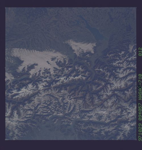
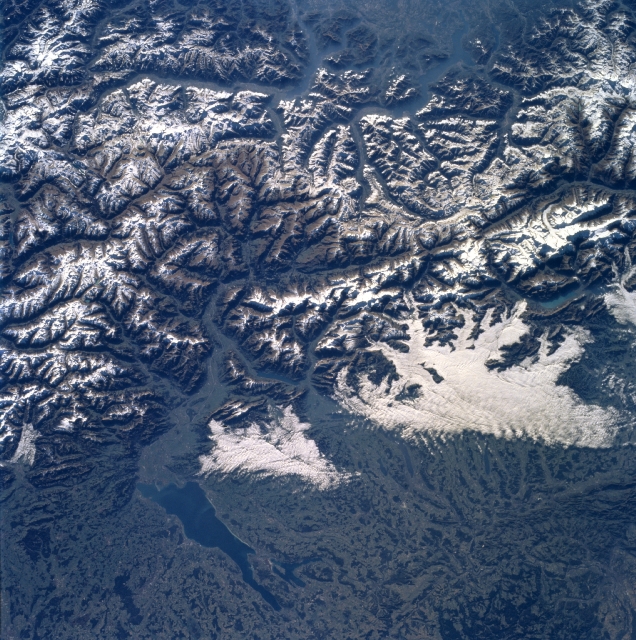
Image Caption: NASA6-710-012 Lake Constance, Alps, Switzerland Fall/Winter 1997
The majestic snow-covered Alps can be seen in the southeastern-looking view. The Alps are the highest mountain range in Europe. The Alps began to form nearly 40 million years ago and continue to grow today as the Africa plate continues to move northward into the European plate. The core of the Alps is composed of hard crystalline rocks, mainly granite, gneiss, and mica schist. Spreading out from this core region is a wide zone of softer sedimentary rocks, mainly hard limestone and weaker sandstones and shale. The Alps form a barrier between the warm air of the Mediterranean to the south and the colder temperatures of northern Europe. The part of the Alps shown in this image is the source of the Rhine River. In the bottom left portion of the image, Lake Constance is discernible. The lake, which is 42 miles (68 km) long and covers an area of 208 square miles (539 square km), is fed by and drained by the Rhine River. The lake has a maximum depth of 827 feet (252 meters). Fruit is grown on the lake's fertile shores, and wine making, fishing, and tourism are major industries.
The majestic snow-covered Alps can be seen in the southeastern-looking view. The Alps are the highest mountain range in Europe. The Alps began to form nearly 40 million years ago and continue to grow today as the Africa plate continues to move northward into the European plate. The core of the Alps is composed of hard crystalline rocks, mainly granite, gneiss, and mica schist. Spreading out from this core region is a wide zone of softer sedimentary rocks, mainly hard limestone and weaker sandstones and shale. The Alps form a barrier between the warm air of the Mediterranean to the south and the colder temperatures of northern Europe. The part of the Alps shown in this image is the source of the Rhine River. In the bottom left portion of the image, Lake Constance is discernible. The lake, which is 42 miles (68 km) long and covers an area of 208 square miles (539 square km), is fed by and drained by the Rhine River. The lake has a maximum depth of 827 feet (252 meters). Fruit is grown on the lake's fertile shores, and wine making, fishing, and tourism are major industries.
