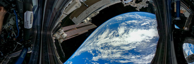
ISS066-E-85163
| NASA Photo ID | ISS066-E-85163 |
| Focal Length | 3mm |
| Date taken | 2021.11.30 |
| Time taken | 19:29:54 GMT |


Spacecraft nadir point: 30.2° S, 150.8° W
Photo center point:
Photo center point by machine learning:
Photo center point:
Photo center point by machine learning:
Nadir to Photo Center:
Spacecraft Altitude: 228 nautical miles (422km)
Country or Geographic Name: | |
Features: | |
| Features Found Using Machine Learning: | PAN- |
Cloud Cover Percentage: | 8 (1-10)% |
Sun Elevation Angle: | 57° |
Sun Azimuth: | 84° |
Camera: | GoPro GoPro Max S/N: C3353424742459 |
Focal Length: | 3mm |
Camera Tilt: | |
Format: | |
Film Exposure: | |
| Additional Information | |
| Width | Height | Annotated | Cropped | Purpose | Links |
|---|---|---|---|---|---|
| 4320 pixels | 1440 pixels | No | No | Download Image | |
| 640 pixels | 213 pixels | No | No | Download Image |
Download Packaged File
Download a Google Earth KML for this Image
View photo footprint information
Download a GeoTIFF for this photo
Image Caption: none
