ISS064-E-26355
| NASA Photo ID | ISS064-E-26355 |
| Focal Length | 800mm |
| Date taken | 2021.01.23 |
| Time taken | 21:30:42 GMT |
720 x 480 pixels 720 x 480 pixels 5568 x 3712 pixels 640 x 427 pixels
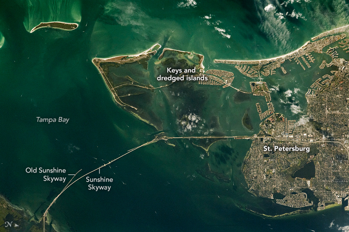


Photo center point: 27.7° N, 82.7° W
Photo center point by machine learning:
Country or Geographic Name: | USA-FLORIDA |
Features: | TAMPA BAY, ST PETERSBURG, SUNSHINE SKYWAY BRIDGE |
| Features Found Using Machine Learning: | |
Cloud Cover Percentage: | 10 (1-10)% |
Sun Elevation Angle: | 18° |
Sun Azimuth: | 235° |
Camera: | Nikon D5 Electronic Still Camera |
Focal Length: | 800mm |
Camera Tilt: | 26 degrees |
Format: | 5568E: 5568 x 3712 pixel CMOS sensor, 35.9 x 23.9 mm, total pixels: 21.33 million, Nikon FX format |
Film Exposure: | |
| Additional Information | |
| Width | Height | Annotated | Cropped | Purpose | Links |
|---|---|---|---|---|---|
| 720 pixels | 480 pixels | Yes | No | Download Image | |
| 720 pixels | 480 pixels | Yes | No | Download Image | |
| 5568 pixels | 3712 pixels | No | No | Download Image | |
| 640 pixels | 427 pixels | No | No | Download Image |
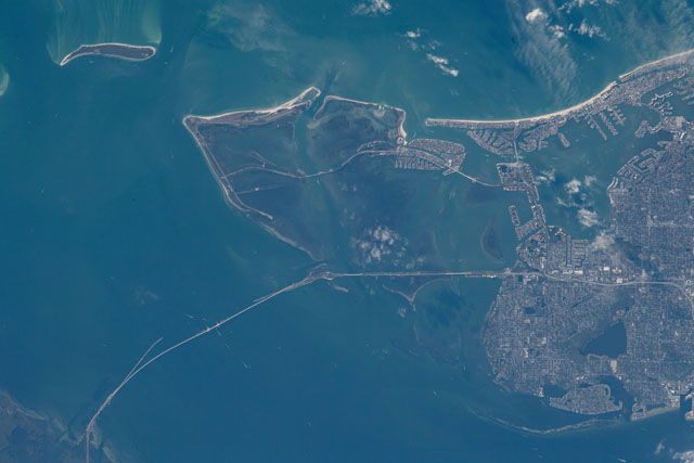
In this photograph taken by an astronaut on the International Space Station (ISS), white wakes mark the paths of ships passing under the Sunshine Skyway, a main thoroughfare between parts of Tampa Bay. Appearing as a large bite out of the western coastline, Tampa Bay is one of the defining features of the Florida coast when viewed from the ISS by day and by night. The different shades of color in and around the bay illustrate variations in water depth and the movement of suspended sediment.
Until 1954, travel between the various cities within the Tampa Bay area was primarily ferry-based. The original Sunshine Skyway Bridge, stretching between St. Petersburg and Palmetto, sought to connect the regions of the bay. For a time it was the longest pre-stressed bridge in the United States, according to the Tampa Bay Times. After a major ship-related accident in 1980, the bridge was dismantled and turned into piers that now appear like branches when viewed from above. The piers stand on the southwestern side of the new bridge, also named the Sunshine Skyway.
In addition to the Skyway - the tallest manmade point in Tampa - smaller bridges have been built to connect other keys that lie around the mouth of Tampa Bay. The keys are small, sandy buildups on the surface coral reefs, and they have been joined by man-made islands and piers. Florida granted a multitude of dredge and fill permits in the mid-1900s, allowing developers to dig sand from the bay and use the material to augment and adapt the existing landscape. These developments have become densely populated neighborhoods between the undeveloped - and now often protected - natural keys.
