ISS064-E-15818
| NASA Photo ID | ISS064-E-15818 |
| Focal Length | 340mm |
| Date taken | 2020.12.26 |
| Time taken | 12:53:36 GMT |
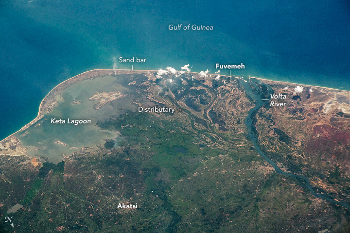


Photo center point: 5.9° N, 0.7° E
Photo center point by machine learning: 5.89° N, 0.78° E

Country or Geographic Name: | GHANA |
Features: | KETA LAGOON, VOLTA RIVER, SONGOR LAGOON |
| Features Found Using Machine Learning: | |
Cloud Cover Percentage: | 10 (1-10)% |
Sun Elevation Angle: | 54° |
Sun Azimuth: | 201° |
Camera: | Nikon D5 Electronic Still Camera |
Focal Length: | 340mm |
Camera Tilt: | 48 degrees |
Format: | 5568E: 5568 x 3712 pixel CMOS sensor, 35.9 x 23.9 mm, total pixels: 21.33 million, Nikon FX format |
Film Exposure: | |
| Additional Information | |
| Width | Height | Annotated | Cropped | Purpose | Links |
|---|---|---|---|---|---|
| 720 pixels | 480 pixels | Yes | No | Download Image | |
| 5568 pixels | 3712 pixels | No | No | Download Image | |
| 640 pixels | 427 pixels | No | No | Download Image |
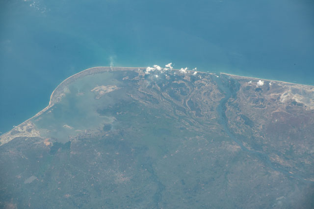
From low-Earth orbit, an astronaut looked south from the International Space Station (ISS) and shot this photograph of coastal Ghana. The image shows the Volta River Delta, with a smooth sandbar closing off Keta Lagoon from the Gulf of Guinea. Distributary channels of the delta show that the Volta River used to flow into the lagoon.
Keta Lagoon is one of approximately 90 lagoons along Ghana's coast, and it supports subsistence and commercial fisheries for local communities. The country's tropical climate also supports mangrove forests.
Vast river systems - including the Volta - flow down from highlands in Burkina Faso, south across Ghana, and into the Gulf of Guinea. These rivers support the farms that sustain the country's economy, producing crops such as yams, grains, cocoa, and oil palms.
As climate change contributes to sea level rise, coastal flooding and erosion pose an imminent threat to Ghana's coastal communities. Along a narrow strip of land between the lagoon and the gulf, the fishing village of Fuvemeh has been essentially swallowed by the sea, displacing its inhabitants. The shoreline here has been eroding at rates up to 2 meters per year, a dangerously rapid rate for coastal communities.
