ISS064-E-11821

| NASA Photo ID | ISS064-E-11821 |
| Focal Length | 100mm |
| Date taken | 2020.12.11 |
| Time taken | 08:30:03 GMT |
4928 x 2768 pixels 720 x 480 pixels 4928 x 2768 pixels 640 x 359 pixels
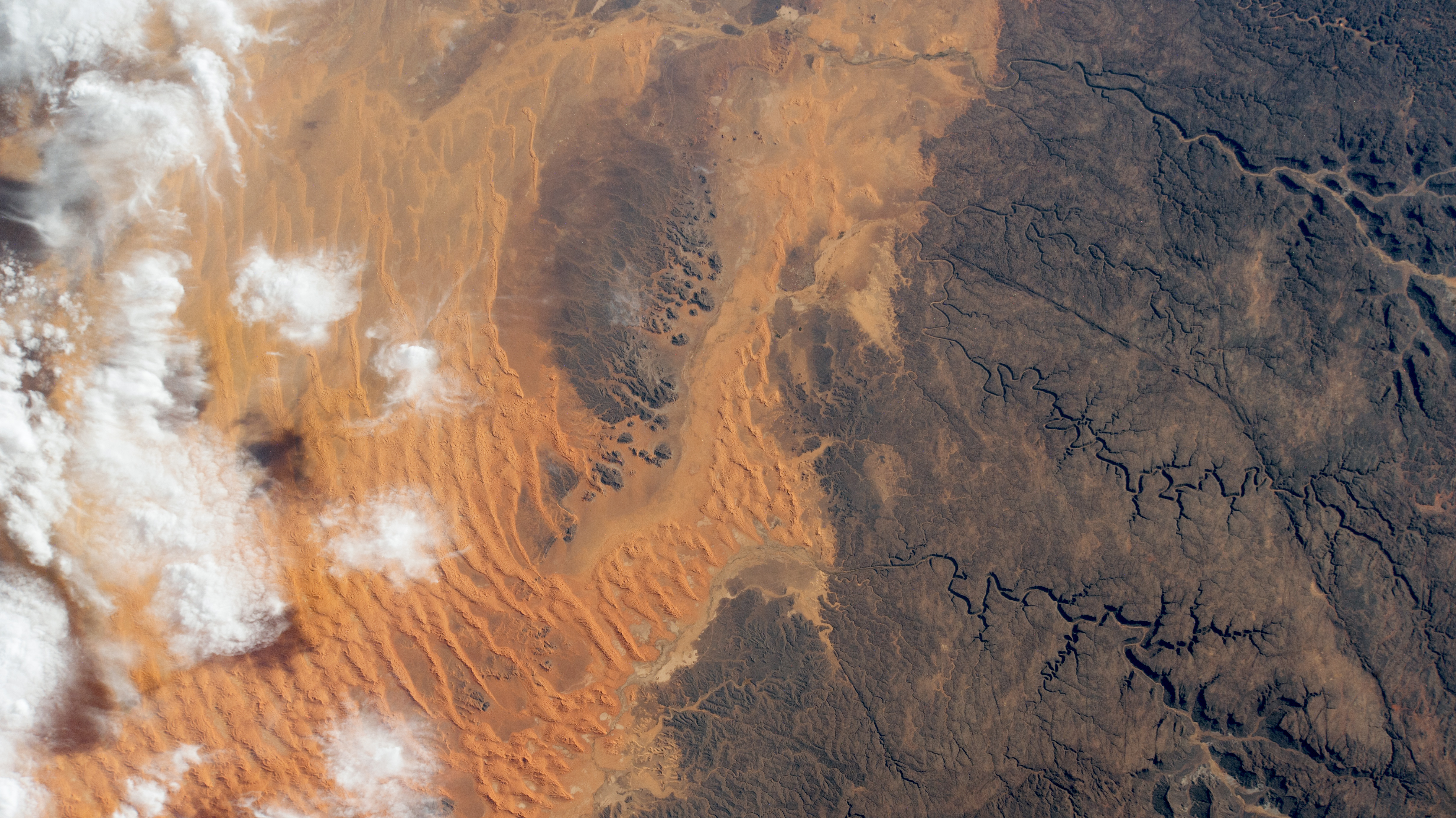
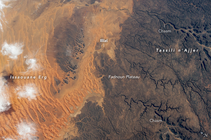
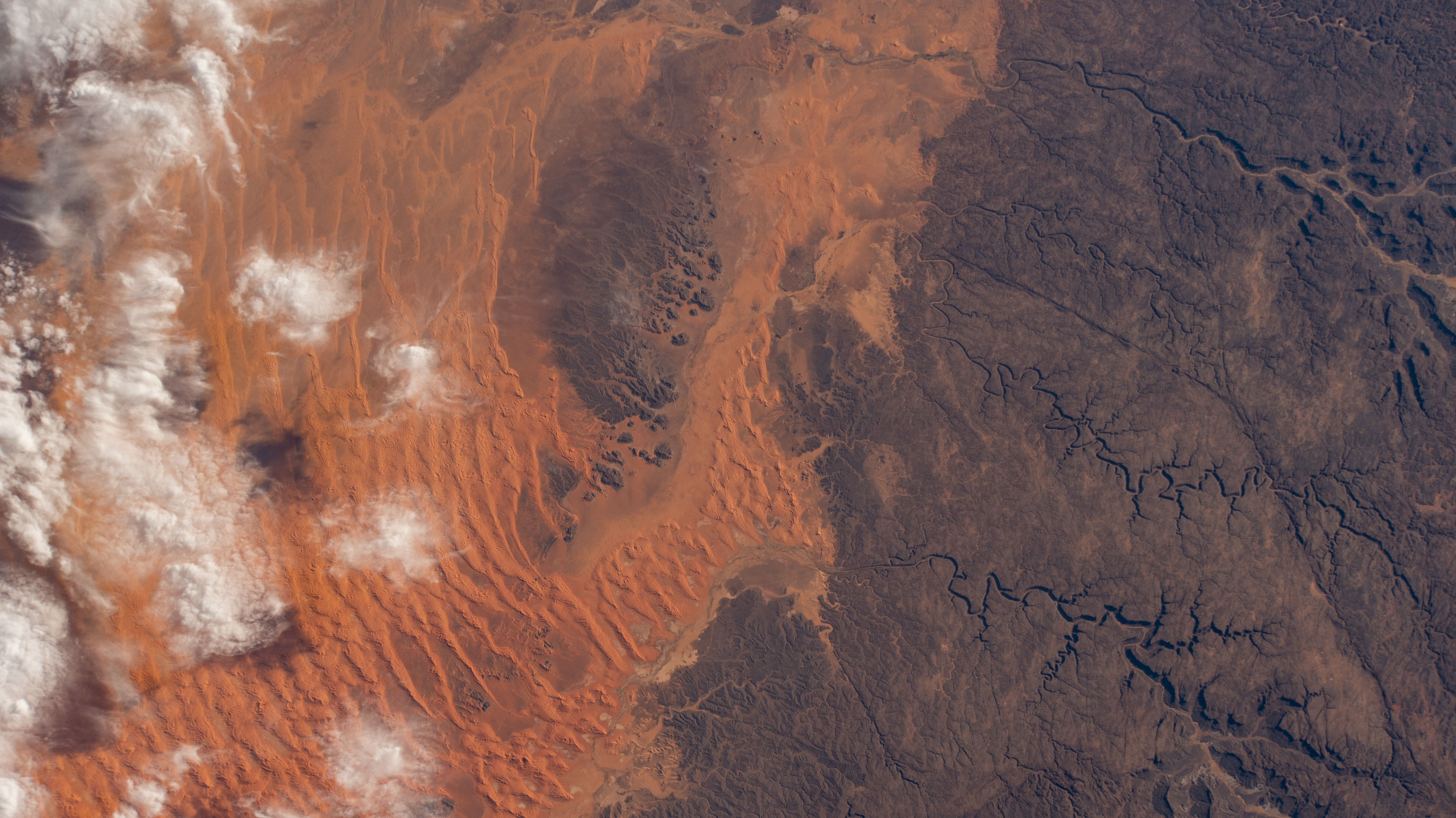


Photo center point: 26.6° N, 8.3° E
Photo center point by machine learning: 26.54° N, 8.29° E

Country or Geographic Name: | ALGERIA |
Features: | DUNES, TASSILI N AJJER DESERT, SAHARA DESERT, ILLIZI, RIVER |
| Features Found Using Machine Learning: | |
Cloud Cover Percentage: | 25 (11-25)% |
Sun Elevation Angle: | 25° |
Sun Azimuth: | 135° |
Camera: | Nikon D4 Electronic Still Camera |
Focal Length: | 100mm |
Camera Tilt: | 31 degrees |
Format: | 4928E: 4928 x 3280 pixel CMOS sensor, 36.0mm x 23.9mm, total pixels: 16.6 million, Nikon FX format |
Film Exposure: | |
| Additional Information | Image acquired by ISS External High Definition Camera |
| Width | Height | Annotated | Cropped | Purpose | Links |
|---|---|---|---|---|---|
| 4928 pixels | 2768 pixels | Yes | Yes | NASA's Earth Observatory web site | Download Image |
| 720 pixels | 480 pixels | Yes | Yes | NASA's Earth Observatory web site | Download Image |
| 4928 pixels | 2768 pixels | No | No | Download Image | |
| 640 pixels | 359 pixels | No | No | Download Image |
Orange-hued dunes mantle dark sandstone on the northern edge of Algeria's Tassili n'Ajjer National Park (//world-heritage-datasheets.unep-wcmc.org/datasheet/output/site/tassili-najjer-national-park/) in this photo from an Earth-facing external camera mounted on the International Space Station. The park's name translates to "plateau of chasms", and these signature ravines wind through the rock in the right of the image. On the left, wisps of cloud overlie a dune field that has swept over the low-lying regions north of the Fadnoun Plateau.
Rising to elevations of over 1,500 meters (4,900 feet) on average, the current plateau has been shaped by thousands of years of water and wind erosion. Though the area is now hyper-arid, ancient rivers once cut narrow canyons almost 240 meters (800 feet) deep into the sandstone as they flowed north toward lakes that filled what are now large dune fields called ergs ("sand seas"). Issaouane Erg, shown above, contains some of the tallest star dunes on Earth. Another erosional feature is the "forest of rock" (//www.archmillennium.net/tassili_national_park.htm) large pillars of resistant sandstone that have remained as strong winds eroded the softer surrounding rock.
The town of Illizi, home to more than 17,000 people, stands at the northern edge of the plateau and continues a chain of human habitation in the region that dates back to 10,000 BCE. Rock engravings mark this long history and have made the plateau a rich area of study for archeologists and anthropologists.
