ISS063-E-88524

| NASA Photo ID | ISS063-E-88524 |
| Focal Length | 800mm |
| Date taken | 2020.09.15 |
| Time taken | 18:20:19 GMT |
5568 x 3712 pixels 720 x 480 pixels 5568 x 3712 pixels 640 x 427 pixels
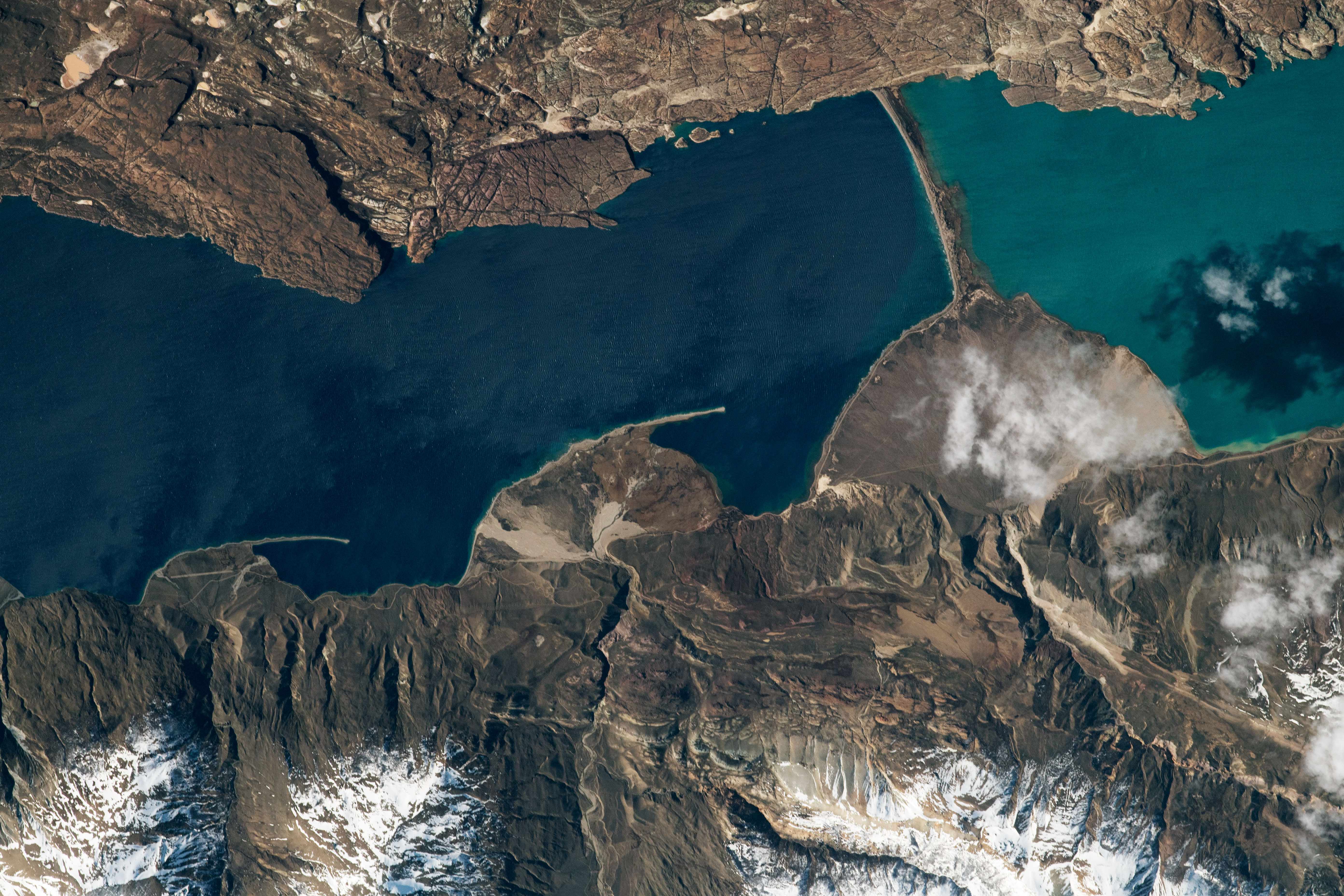
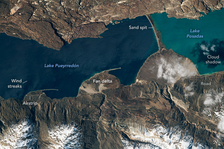
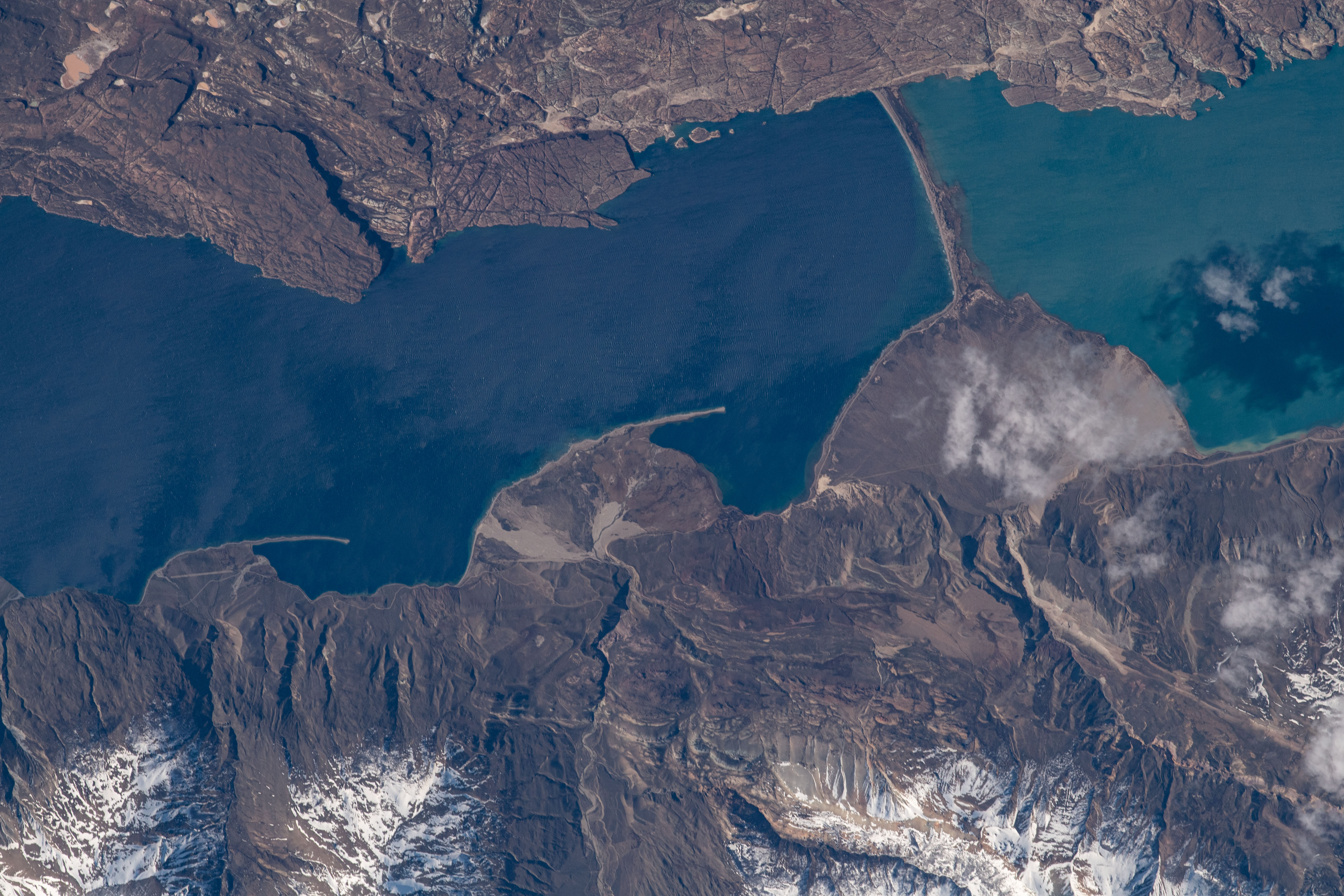


Photo center point: 47.4° S, 71.9° W
Photo center point by machine learning: 47.42° S, 71.92° W

Country or Geographic Name: | ARGENTINA |
Features: | POSADAS LAKE, COCHRANE LAKE |
| Features Found Using Machine Learning: | |
Cloud Cover Percentage: | 10 (1-10)% |
Sun Elevation Angle: | 35° |
Sun Azimuth: | 325° |
Camera: | Nikon D5 Electronic Still Camera |
Focal Length: | 800mm |
Camera Tilt: | 44 degrees |
Format: | 5568E: 5568 x 3712 pixel CMOS sensor, 35.9 x 23.9 mm, total pixels: 21.33 million, Nikon FX format |
Film Exposure: | |
| Additional Information | |
| Width | Height | Annotated | Cropped | Purpose | Links |
|---|---|---|---|---|---|
| 5568 pixels | 3712 pixels | Yes | No | Download Image | |
| 720 pixels | 480 pixels | Yes | No | Download Image | |
| 5568 pixels | 3712 pixels | No | No | Download Image | |
| 640 pixels | 427 pixels | No | No | Download Image |
An astronaut onboard the International Space Station shot this photograph of Lake Pueyrredon and Lake Posadas in the Patagonia region of southern Argentina. Snow-covered foothills of the Andes Mountains appear along the lower margin. Streaks on the lake surface are produced by the strong winds that are very common in the region. The dark shadow of a cloud falls on the surface of Lake Posadas. Though the permanent population is small, tourism brings many people to Patagonia's lake region; the small airstrip and lakeside road aid with arrivals.
Rivers from the local hills have dumped sediment on the shores of the lakes to form small deltas. Three are prominent on the shore of Lake Pueyrredon. (To the west in Chile, Lake Pueyrredon is known as Lake Cochrane.) Very strong and persistent winds have generated waves and currents powerful enough to erode sand from the toes of the fan-deltas, creating long, thin sand spits pointing down-current.
The biggest delta is connected to the opposite shore by a sand bar 3.5 kilometers (2.2 miles) long; it actually may be an ancient moraine. This sand bar cut off the eastern end of Lake Pueyrredon to form the smaller Lake Posadas. Posadas is lighter in color because of the light-toned sediment flowing into it from the incoming river.
Land surfaces here have been dynamic in the past one or two million years. Geologists now know that ice sheets that formed along the nearby Andes Mountains have expanded repeatedly, each time covering almost the entire area shown in the photo. Other astronaut photos such as this one show the Northern Patagonian ice sheet that affected Lake Pueyrredon.
