ISS061-E-98063
| NASA Photo ID | ISS061-E-98063 |
| Focal Length | 800mm |
| Date taken | 2019.12.25 |
| Time taken | 11:57:10 GMT |
5568 x 3712 pixels 720 x 480 pixels 5568 x 3712 pixels 640 x 427 pixels

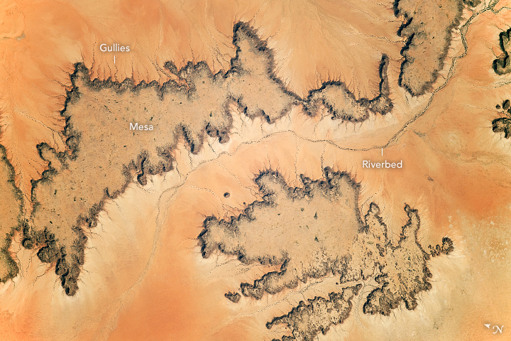


Photo center point: 15.8° N, 25.4° E
Photo center point by machine learning:
Country or Geographic Name: | SUDAN |
Features: | LIBYAN DESERT, MARRAH MOUNTAINS |
| Features Found Using Machine Learning: | |
Cloud Cover Percentage: | 10 (1-10)% |
Sun Elevation Angle: | 43° |
Sun Azimuth: | 213° |
Camera: | Nikon D5 Electronic Still Camera |
Focal Length: | 800mm |
Camera Tilt: | 19 degrees |
Format: | 5568E: 5568 x 3712 pixel CMOS sensor, 35.9 x 23.9 mm, total pixels: 21.33 million, Nikon FX format |
Film Exposure: | |
| Additional Information | |
| Width | Height | Annotated | Cropped | Purpose | Links |
|---|---|---|---|---|---|
| 5568 pixels | 3712 pixels | No | No | NASA's Earth Observatory web site | Download Image |
| 720 pixels | 480 pixels | Yes | No | NASA's Earth Observatory web site | Download Image |
| 5568 pixels | 3712 pixels | No | No | Download Image | |
| 640 pixels | 427 pixels | No | No | Download Image |
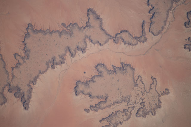
Taken by astronauts aboard the International Space Station, this detailed photograph shows dark surfaces in the hyper-arid eastern Sahara Desert in Sudan. These surfaces are flat-topped mesas that rise 70-140 meters (230-460 feet) above the surrounding lighter-toned landscape. The mesas are defined by vertical cliffs cut into by numerous small gullies, producing a heavily indented pattern. For scale, the smaller mesa measures 10 kilometers (6 miles) long.
The bed of a dry river winds across the middle of the image. A dotted pattern of trees and clumps of bushes follow the line of the riverbed, indicating that roots are reaching the subsurface water. (Click on the image to see a more detailed view.)
Analysis of the height of the mesas and the rock units exposed in the cliff faces allows geologists to interpret the evolution of the area's landscape. It is possible to conclude that the rock layer forming the two mesas was more extensive in the past, and that it has been stripped away by river and wind erosion to produce the younger, light-toned surface seen today.
Eroded desert landscapes with strongly contrasting darker and lighter-toned surfaces result from both physical and chemical weathering processes and are a common landscape pattern in this part of the Sahara Desert. Geologic maps indicate that the entire area is a single rock type known as the Nubian Sandstone, which is one of the largest fossil water aquifers in the world.
